Purranque
| Purranque | ||
|---|---|---|
|
Coordinates: 40 ° 55 ′ S , 73 ° 10 ′ W Purranque on the map of Chile
|
||
| Basic data | ||
| Country | Chile | |
| region | Región de los Lagos | |
| City foundation | April 18, 1911 | |
| Residents | 20,949 (2006) | |
| Detailed data | ||
| surface | 1.459 km 2 | |
| Population density | 14.36 inhabitants / km 2 | |
| height | 118 m | |
| Post Code | 5380000 | |
| prefix | 056-64 | |
| Time zone | UTC −4 | |
| City Presidency | César Negrón swords | |
| Website | ||
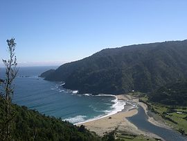
| Manquemapu Bay, a marine landscape and trekking destination on the Purranque coast. | ||
| Location Purranque in the Región de los Lagos | ||
Purranque is a town and municipality that belongs to the province of Osorno in the Chilean Región de los Lagos (Lake District). It has about 20,000 inhabitants and is located on the Panamericana main road, towards Patagonia . It is 45 km south of Osorno and 63 km north of Puerto Montt .
history
The Huilliche tribe lived in the area that used to be called Purranquíl until the beginning of the 19th century . Its chief Railef sold the area to the first Spaniards. The route of the Spaniards ran through the area of the Camino Real (Royal Route), which connected Valdivia and the Chiloé archipelago .
In 1813, Camilo Santibanez, the first resident of European origin, bought the area from Railef , which from then on bore the name Fundo Dollinco . It later became the property of the large landowner Félix Rosas Manrique de Lara .
The town of Purranque was founded on April 18, 1911 as Villa Lo Burgos by Tomás Burgos Sotomayor . He married the daughter of Félix Rosas Manrique de Lara, Sofía Rosas Durán, who had inherited part of the Dollinco area .
In order to get a connection to the planned railway network , Tomás Burgos Sotomayor founded the city with foresight. This brought progress to the area. This railway connects the important cities of Osorno and Puerto Montt to this day .
An official decree from 1915 recognized the creation of Villa Lo Burgos . In 1941 Purranque was elevated to a parish and the corresponding boundaries were established.
A large number of families currently living in the Purranque area came from a wave of German immigration that came to the ports of Corral (Chile) and Puerto Montt in the mid-19th century (1846) . As colonies , they contribute to the development of agriculture , crafts and trade in southern Chile.
economy
The local economy consists primarily of agricultural products and livestock . This part of the Osorno province is known for its beef , which is sold in all Chilean regions. There are also small and medium-sized companies that manufacture dairy products for the southern and central regions of Chile. Berries and the food produced from them are mainly exported.
tourism
In recent years, the expansion of agrotourism has started. The area of the coastal mountain range and the Pacific coast offer attractive destinations for trekking tours, such as Bahía San Pedro , the Bay of San Carlos and Manquemapu . These places can also be reached by four-wheel drive vehicles .
Religious celebrations
The feast of St. Sebastian, the city's patron saint , has been celebrated since 1935 and has revived a tradition of the first Spanish arrivals in southern Chile. Every January 20th, around 30,000 pilgrims from all regions of Chile gather.


