Ruta 7 (Chile)
| Ruta 7 in Chile | |

|
|
| Basic data | |
| Operator: | |
| Overall length: | 1350 km |
|
Región (region): |
|
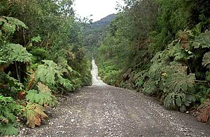
| Carretera Austral between Caleta Gonzalo and Chaiten (2006) | |

|
|
|
|
Carretera Austral (paved) |
|
|
Carretera Austral (gravel road) |
|
|
Branch line (gravel road) |
|
|
Track under construction |
|
|
Projected route |
|
|
Ferry line |
|
|
Panamericana |
|
|
State border |
|
|
Regional border |
The Carretera Austral (official name Ruta CH-7 ) is an approximately 1350 kilometer long road in Chile that leads from Puerto Montt to Villa O'Higgins on the southern border of the Región de Aisén . The construction of the road has not yet been completed. It has the status of a national longitudinal axis .
construction

For a long time the extreme south of Chile could only be reached by plane or ship. The Panamericana Highway does not lead through this impassable area, but via Argentina to Tierra del Fuego . The reason is the dense forest cover of the area and the mountainous terrain, criss-crossed by numerous obstacles, whereas the Argentinian Patagonia is very barren and relatively spacious and therefore much easier to develop.
In 1976, under the military dictatorship of Augusto Pinochet, construction began on a road through the south. The Carretera Austral (“Southern Highway”) was the most complex major project in Chile in the 20th century and was considered a prestige project of the regime; it was initially named after General Pinochet. The starting point for the construction was the city of Puerto Montt ; military considerations (securing the southern border of Chile against claims by Argentina) played an essential role in the planning. More than 10,000 soldiers were temporarily used for the construction. Road construction proved to be extremely difficult as the landscape is cut through by fjords , glaciers and mountain ranges. A direct north-south connection was technically impossible, so around 1150 km of the route lead from north to south and around 229 km from west to east. Four straits have to be crossed by ferry.
The construction cost around 200 million US dollars and the current road was built well into the 1990s. Nevertheless, parts of the Carretera Austral are easy gravel roads; the maintenance and care proves to be complex. The northern part between Puerto Montt and Chaitén was also not completed for a long time; a ferry runs between Hornopirén and Caleta Gonzalo . About a third of the Carretera Austral is now paved. At the moment the asphalt ends about an hour's drive southwest of Balmaceda behind the Villa Cerro Castillo settlement. According to the regional tourism authority, there are plans to completely asphalt the existing road in the coming decades. The Lago O'Higgins and the southern ice field of Patagonia prevent further construction at the southern end . The road ends in Bahía Bahamóndez , a bay on Lake O'Higgins, where a wooden plaque announces the end of the Carretera Austral .
tourism
The road is an insider tip for enduro riders who want to enjoy the magnificent landscape. A rental car drive in 2015 was reported on March 20, 2016 in the Frankfurter Allgemeine Sonntagszeitung .
Cities
Cities on the Carretera Austral from north to south:
- Puerto Montt
- Chaitén
- Coyhaique
- Puerto Ingeniero Ibáñez
- Chile Chico
- Cochrane
- Puerto Yungay
- O'Higgins mansion
Continuation of construction
In order to close the gap between the Magellan region and the rest of Chile in the long term, the military construction command Cuerpo Militar de Trabajo is continuing the construction of the missing section despite the very difficult terrain. This should run west of the southern ice field parallel to the Messier Canal . Work is currently underway on two sections between the Río Bravo and the Jorge Montt Glacier in the north and between Puerto Natales and the Stanley Fjord in the south. A construction period of 25 to 30 years is estimated for the 935 missing kilometers, the plan assumes nine ferry connections because of the rugged terrain by fjords.
literature
- Malte Sieber: Chile and Easter Island. 9th, revised and completely updated edition. Reise Know-How Verlag Peter Rump , Bielefeld 2015, ISBN 978-3-8317-2614-1 , pp. 333–383.
Web links
- Andreas Drouve: At the wild end of Chile's legendary highway. In: Die Welt , February 14, 2018, accessed on October 14, 2018.
Individual evidence
- ↑ Mirco Lomoth: Make out of the dust (PDF; 864 kB). In: Frankfurter Allgemeine Sonntagszeitung , No. 11, March 20, 2016, p. 66.
- ↑ Nuevos trazados. Vialidad Nacional, archived from the original on January 24, 2010 ; Retrieved March 3, 2009 .
- ^ Carretera Austral se prolongará hasta la región de Magallanes. El Mercurio / Ministerio de Obras Públicas, October 14, 2006, archived from the original on December 8, 2008 ; Retrieved March 3, 2009 .
