
Ruta 23 (Chile)
| Ruta 23 in Chile | |||||||||||||||||||||||||||||||||||||||||||||||||||||||||||||||||||||||||
.svg)
|
|||||||||||||||||||||||||||||||||||||||||||||||||||||||||||||||||||||||||
| map | |||||||||||||||||||||||||||||||||||||||||||||||||||||||||||||||||||||||||
.svg) |
|||||||||||||||||||||||||||||||||||||||||||||||||||||||||||||||||||||||||
| Basic data | |||||||||||||||||||||||||||||||||||||||||||||||||||||||||||||||||||||||||
| Operator: | |||||||||||||||||||||||||||||||||||||||||||||||||||||||||||||||||||||||||
| Overall length: | 312 km | ||||||||||||||||||||||||||||||||||||||||||||||||||||||||||||||||||||||||
|
Región (region): |
|||||||||||||||||||||||||||||||||||||||||||||||||||||||||||||||||||||||||
| Development condition: | 1 × 2 lanes | ||||||||||||||||||||||||||||||||||||||||||||||||||||||||||||||||||||||||
|
Course of the road
|
|||||||||||||||||||||||||||||||||||||||||||||||||||||||||||||||||||||||||
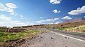
The Ruta 23 ( 23-CH for short ) is an international road in the Región de Antofagasta in the great north of Chile . It runs over 312 km from the city of Calama through the municipality of San Pedro de Atacama to the Paso Sico , the border pass to Argentina .
The road is completely paved between Calama and the Sico border crossing. In San Pedro there is a 13.2 km long bypass, which leads the truck past the tourist village.
In terms of tourism, the route leads through areas of particular beauty, such as the Atacama Desert , through the Cordillera de la Sal near the Valle de la Luna in the Los Flamencos National Reserve , through the San Pedro de Atacama oasis with its sights Aldea de Tulor , Pukará de Quitor , Salar de Atacama and at the end through the Chilean Altiplano with its salt lakes and volcanoes.
Between Toconao and the border with Argentina, the region crossed by the 23-CH is extremely sparsely populated. Large areas of the street belong to San Pedro with a population density of one adult per 4 km², most of whom live in this city and its suburbs. This city has an area of 23,439 km² and thus has a larger area than the German state of Hesse with around 5300 inhabitants .
Together with Rutas 25 , 27 and 5 Panamericana , it belongs to the Corredor Bioceánico Eje del Capricornio , which leads to Antofagasta . The highway continues in Argentina as RN 51 to the cities of San Antonio de los Cobres and Salta .
The official function of this Ruta was ratified in 2000 by Decree Nº 2136 by the Ministerio de Obras Públicas de Chile (MOP).
Views

km 30.5, 2660 m above sea level M.
( 22 ° 37 ′ S , 68 ° 39 ′ W ) towards San Pedro de Atacama. The first 55 km are a monotonous route through the flat, gray Atacama desert. On the horizon the Cordillera de Domeyko, which from this perspective still covers the Andes from 25 km away.
km 58, 3418 m above sea level M .:
( 22 ° 43 ′ S , 68 ° 24 ′ W ) At the highest point over the Paso Barros Arana through the plateau of the Cordillera de Domeyko. In the background the Licancabur volcano, the most striking mountain in the Andean panorama.
km 76, 2690 m above sea level M.
( 22 ° 50 ′ S , 68 ° 20 ′ W ) The drawn-out descent from the Cordillera de Domeyko into the Preanden Basin of San Pedro has some dangerous curves. A memorial ( Animita ) with a wrecked car testifies to this.
km 92, 2465 m above sea level M.
( 22 ° 54 ′ S , 68 ° 13 ′ W ) through the Cordillera de la Sal (red salt-sandstone rocks) near San Pedro.
To the south of San Pedro there are often animals on and on the road.
km 192, 3275 m above sea level M.
( 23 ° 36 ′ S , 67 ° 53 ′ W ) Socaire, a mountain village in a sheltered place in the Altiplano.
km 290, 4315 m. ü. M.
( 23 ° 50 ′ S , 67 ° 27 ′ W ) Border control point Sico-Pass, approx. 22 km before the border.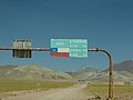
km 312, 4092 m. ü. M.
( 23 ° 50 ′ S , 67 ° 15 ′ W ) On the border between Chile and Argentina at the Sico Pass


Cities and towns
The towns, villages and settlements along the sections from west to east are
Antofagasta region
- Length: 312 km (km 0 to 312).
- Provincia de El Loa : Calama (km 0), connection to Villa Peuco-Maratón (km 0.8), connection to Guardería CONAF Valle de la Luna (km 81), connection to San Pedro de Atacama (km 94 and 105), Connection to Guardería CONAF Valle de la Luna and Aldea de Tulor (km 98), connection to Atacama Large Millimeter Array (km 121), Toconao (km 139-141), connection to Aguas Blancas (km 150), connection to Camar (km 165), Compañía (km 188), connection to San Francisco (km 191), Socaire (km 191-192), El Laco police station (km 290).
Individual evidence
- ↑ a b c d e Chile completó hasta el límite con Salta el pavimento de la ruta 23-CH. In: Noticia de Salta. Secretaria General de la Gobernación de ls Provincia de Salta, March 6, 2018, accessed March 23, 2018 (Spanish).
- ↑ a b Red vial en la Región de Antofagasta en Dirección de Vialidad Chile ( Memento from August 31, 2011 in the Internet Archive )