Ruta 11 (Chile)
| Ruta 11 in Chile | |||||||||||||||||||||||||

|
|||||||||||||||||||||||||
| map | |||||||||||||||||||||||||
| Basic data | |||||||||||||||||||||||||
| Operator: | |||||||||||||||||||||||||
| Overall length: | 192.2 km | ||||||||||||||||||||||||
|
Región (region): |
|||||||||||||||||||||||||
| Development condition: | 1 × 2 lanes | ||||||||||||||||||||||||
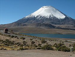
| Ruta 11 in front of Lago Chungara and the Parinacota volcano . | |||||||||||||||||||||||||
|
Course of the road
|
|||||||||||||||||||||||||
The Ruta 11 ( 11-CH for short ) is a trunk road in the South American Andean state of Chile . It is one of the country's international roads and bears the name Ruta 11. It is part of the Corredor bioceánico , a road network that connects the Pacific with the Atlantic . The Ruta 11 is located in northern Chile in the Región de Arica y Parinacota . It is completely paved over its entire length of 192.2 km . and connects via the Paso Chungará-Tambo Quemado border pass the Ruta 5 and Arica with Putre , the settlements in the Altiplano and Bolivia. This pass is one of the most important passports in Chile. It is also intended to link the port of Arica with neighboring countries and to promote the port's activity.
The road begins at the Los Libertadores roundabout on the edge of the Puerta Las Américas industrial area , a few kilometers north of Arica. Continuously climbing uphill, it runs alongside the railway line to La Paz through the Valle de Lluta . At the end of the valley, the El Águila pass begins in serpentines of tight curves . The route touches small villages and winds around hills, mountains and bofedale (water-rich moors), which are home to the region's typically rich fauna. It is also an important tourist route because it also leads to the Quebrada de Cardones Natural Monument and the Lauca National Park .
Customs control is located west of the Puerto de montaña border crossing and on the southern edge of Lake Chungará . The road continues in Bolivia as Ruta 4 in the direction of Oruro .
The official function of this Ruta was ratified in 2000 by Decree Nº 2136 by the Ministerio de Obras Públicas de Chile (MOP).
Cities and towns
The towns, villages and settlements along the north-south section are:
Región de Arica y Parinacota
- Length: 192 km (km 0 to 192). The route is called Avenida Libertador Simón Bolívar between the Los Libertadores roundabout and the industrial area of Puerta Las Américas .
- Provincia de Arica : Connection to Villa Frontera (km 0).
- Provincia de Parinacota : Connection to Putre (km 127 and 135), ends at the Chungará border crossing (km 185)
Traffic safety
Regional officials such as the Mayor of Arica , Carlos Valcarce , have publicly drawn attention to the poor condition of the road and the number of serious accidents there. However, there are doctors who claim that the physiological effect of altitude on the drivers may also be a cause of the accidents. There is still disagreement among experts on this issue.
In March 2006 a minibus fell over 250 m into a ravine at km 46. 12 foreign tourists died in this accident. On August 29, 2008, 9 children died when a bus with 27 students overturned in a curve 5 km from Putre. Between 2005 and 2008 there were 31 deaths, including 4 Bolivian truck drivers.
The speed limit of the Ruta is 100 km / h, in some areas only 30 km / h. Due to the accident in March 2006, crash barriers were installed on some sections of the Ruta .
The route is also heavily exposed to the effects of the climate in the Altiplano. So there are always landslides, caused by the rain and thermal fluctuations. Metal fences, which were installed in March 2009, as well as further changes in the most endangered areas are to help.
It can be emphasized that 4,600,000 heavy traffic vehicles circulate on the Ruta (according to the MOP ), and there is a daily traffic volume of around 300 vehicles, 100 of which are Bolivian trucks.
Individual evidence
- ↑ a b Red vial regional en la Región de Arica y Parinacota en Dirección de Vialidad Chile
- ↑ Decretos supremos que declaran caminos públicos en Dirección de Vialidad Chile ( Memento of October 26, 2012 in the Internet Archive )
- ^ Article "Accidente en nuestra región" in El Mercurio of September 2, 2008
- ↑ a b Article in "La Tercera" ( Memento of September 6, 2008 in the Internet Archive ) of August 29, 2009
- ↑ a b Article "Médicos discrepan sobre el efecto de la altura en la tragedia" in El Mercurio of September 2, 2008
- ↑ Article "31 fallecidos en últimos 4 años" ( Memento from February 28, 2014 in the web archive archive.today ) in La Estrella de Arica from September 1, 2008
- ↑ Article "Juez establece que el chofer de la tragedia no es peligroso y lo deja libre" in El Mercurio of September 2, 2008
- ↑ a b Article "US $ 2 millones requiere ruta a Bolivia para evitar derrumbes" in El Mercurio from October 25, 2008
- ↑ Article "Ruta de la tragedia es una de las más peligrosas del norte" ( Memento of the original dated June 11, 2009 in the Internet Archive ) Info: The archive link was automatically inserted and not yet checked. Please check the original and archive link according to the instructions and then remove this notice. in La Tercera on September 5, 2008


