
Putre
Coordinates: 18 ° 12 ′ S , 69 ° 34 ′ W

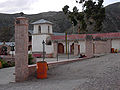
The small town of Putre (2200 inhabitants) is one of the northernmost places in Chile . It is in the XV. Region ( Región de Arica y Parinacota ), around 150 km east of the coastal town of Arica at an altitude of 3650 meters and forms the entrance to the Lauca National Park . Putre is the capital of the Parinacota Province. The landscape around Putre is barren and mountainous, the locals farm for their own needs. There are some tourist facilities and a military base. The church, built in 1670, is worth seeing. Putre has belonged to Chile since the Saltpeter War (1879–1883), previously to Peru .
Surroundings
52 km from Putre is one of the highest lakes in the world, Lago Chungará at an altitude of 4520 meters. The mountain range Nevados de Putre (part of the Andes chain) is home to several large volcanoes , the Pomerape , the Parinacota and the Nevado Sajama across the Bolivian border, which are up to 6500 m high. A few kilometers east of Putre, the Río Lluta flows through the Atacama Desert .
At the salt lake Salar de Surire with its hot springs, you can see pink flamingos , vicuñas and llamas . The salt lake is around 120 km from Putre at an altitude of 4250 meters.
In the area around Putre you can find archaeological sites up to 7000 years old. The indigenous people are called Chucuyo and Parinacota .

Putre in the valley
Putre's market square

