Arica
| Arica | ||
|---|---|---|
|
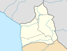
Coordinates: 18 ° 29 ′ S , 70 ° 20 ′ W Arica on the map of Arica y Parinacota
|
||
| Basic data | ||
| Country | Chile | |
| region | Región de Arica y Parinacota | |
| City foundation | April 25, 1541 | |
| Residents | 222,619 (2017) | |
| City insignia | ||
| Detailed data | ||
| surface | 4799 km 2 | |
| Population density | 46 people / km 2 | |
| height | 2 m | |
| Waters | Pacific , Río Lluta | |
| Time zone | UTC −4 | |
| City Presidency | Salvador Urrutia Cárdenas | |
| Website | ||
| Port of Arica | ||
Arica is a city in the far north of the South American Andean state Chile and is located in the Región de Arica y Parinacota , Province de Arica . It is popularly known as the "City of Eternal Spring". The neighboring Peru lost the city during the Saltpeter War . Arica has 222,619 inhabitants (as of 2017).
geography
Arica is the northernmost city of Chile and is only a few kilometers away from the border with Peru on the Pacific . The distance to Santiago is 2051 kilometers. The city is located at the confluence of the Río Lluta and Río San José de Azapa .
The city has a desert climate . The annual mean temperatures fluctuate by almost 19 ° C. It practically never rains. However, water from the Andes ensures green parks and enables extensive agriculture in the river valleys.
|
Average monthly temperatures and rainfall for Arica
Source: wetterkontor.de
|
|||||||||||||||||||||||||||||||||||||||||||||||||||||||||||||||||||||||||||||||||||||||||||||||||||||||||||||||||||||||||||||||||||||||||||||||||||||||||||||||||||||
history
As early as 8000 BC BC and until 2000 BC The Chinchorros people lived in the valley of Arica. From 1450 the Incas invaded northern Chile. Diego de Almagro was the first to reach the Arica area in 1536. Lucas Martínez Vegazo founded Arica on April 25, 1541.
The Spanish fleet and the city were threatened by English privateers at the end of the 17th century . On November 5, 1680, the English pirate Bartholomew Sharp attacked the city with 140 men. Arica could be defended by the Spaniards with heavy losses. A second attack took place on February 9, 1681 by the pirate John Watling with 92 men. Watling died in this attack.
On August 13, 1868, Arica was badly damaged by a tsunami , killing around 300 residents. When the next quake on May 9, 1877, Arica got away with five deaths.
After the wars of independence in South America, Arica initially belonged to Peru. After the discovery of rich saltpeter deposits in the Atacama Desert , the saltpeter war between Peru, Bolivia and Chile broke out. After heavy fighting in the morning hours of June 7, 1880, the Chileans were able to conquer Arica and the fortress on the Morro, the rock above the port of the city, which had been held by the Peruvians until then.
After the end of the war in 1883, Arica was finally incorporated into Chilean territory ( Treaty of Ancón ). Even so, Arica and the Peruvian city of Tacna , located just under 60 kilometers to the north, remained a disputed area until 1929.
Attractions
The customs building in the city was of Gustave Eiffel designed, as is the 1875 built church Catedral de San Marcos in Plaza Colón, a structure made of steel .
The city is developed for tourism and has several beaches . But the city is more suitable as a starting point for excursions in the area, for example in the Andes to Putre , in the Lauca National Park or to Inca settlements.
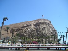
From the Morro de Arica (260 m) you have a beautiful view of the entire city. Above is a statue of Christ that looks towards the Pacific. The hill had a symbolic character during the saltpeter war . An army museum on the hill describes the conquest by the Chilean army on June 7, 1880. From above you can also see the Isla del Alacrán peninsula with the town's small marina.
In San Miguel de Azapa there is an archaeological museum, the Museo Arqueológico San Miguel de Azapa . This is mainly about the ancient Chinchorro culture. Nearby is a cemetery that is said to be the oldest in the world. Colonial tombs are still preserved, but people were buried there as early as the Chincorro culture. The Valle de Azapa valley, characterized by the cultivation of olives and vegetables, with the river Río San José de Azapa is ideal for wonderful hikes, in the upper part there is also the village of Ausipar . In the Valle de Lluta , which is crossed by the water-rich Río Lluta , there are many interesting geoglyphs and petroglyphs to see.
About 25 km south of Arica near the Panamericana , in the middle of the desert, you can find giant modern sculptures called Tutelares by the sculptor Juan Díaz Fleming , which symbolize the tribal origin of the Andean people and the cosmic relationship with the sun and moon.
see also : Quiani
economy
With its branched irrigation system, the Valle de Azapa river valley offers the possibility of large-scale and year-round cultivation of fruits and vegetables, especially olives. Many agricultural products are marketed in the Agropecuario terminal .
Arica is an important port for Chilean ores . In 1953 the city received a free trade zone . Until the 1970s, the settlement of the processing industry - especially the automotive industry - was subsidized by the state. The extremely market-oriented economic policy under the Pinochet dictatorship in the late 1970s and 1980s meant the end of Arica's industry. Today the governments of the Concertación are trying to make the location more attractive again through tax breaks and investment subsidies (“Ley de Arica”).
In addition to trade, tourism is one of the city's main sources of income. Their beaches are particularly attractive to wealthy Bolivians, but also to Chileans from more southern regions - because of the more pleasant water temperatures.
Arica is on the Panamericana . North of the city is the Aeropuerto Internacional Chacalluta Airport . A railway connection between Arica and the Peruvian Tacna opened in 1855, but has since been closed. There is also a railway connection with the Bolivian capital La Paz , but the operating company became insolvent in 2006. After the completion of the rehabilitation of the 206-kilometer section to the Bolivian border in early 2013 by the Port Authority of Arica (EPA), President Piñera reopened the line on May 13, 2013.
From 1962 to 1967, the DiVolvo company assembled Volvo models in Arica.
education
- Universidad de Tarapacá de Arica
Sports
Soccer
In October 1901, the Peruvian ethnic group founded the city's first football club, The Arica Football Club , which was soon followed by others. A little later the first championships against clubs from the city of Tacna were organized.
For the Soccer World Cup 1962 was Carlos Dittborn stadium built. The games of the World Cup group A were held here; then the Chilean team won their quarter-final against the Soviet team here .
The most famous football teams of today are the CD San Marcos de Arica and the team from Universidad de Tarapacá , both of which play in the third Chilean league. (Status: 2007)
CD San Marcos de Arica has now been promoted to the 2nd division and is playing professional football again and just missed promotion to the 1st division in the 2007/2008 season.
surfing
Depending on the season, the Pacific beach offers sufficiently high waves for surfing. In 2007 a competition of the surfing association ASP (now WSL) took place in Arica as part of the Foster's ASP World Tour .
Personalities
- Américo (* 1977), Chilean singer
- Pierre Barbizet (1922–1990), pianist and music teacher
- Guillermo Billinghurst (1851-1915), Peruvian politician
See also
Web links
Individual evidence
- ↑ Censo 2017. Accessed December 30, 2018 (Spanish).
- ↑ Reopening closer for Arica - La Paz. In: railwaygazette.com. January 24, 2013, accessed February 1, 2013 .
- ^ President visits Arica - La Paz Railway. In: railwaygazette.com. May 15, 2013, accessed May 23, 2013 .
- ↑ Manuel Romo Sanchez: "La masonería en Arica en el siglo XIX Segunda parte: 1893-1905" ( Memento of September 29, 2007 in the Internet Archive ), Santiago de Chile 2006; sighted November 27, 2007; Romo Sánchez gives the newspaper El Morro de Arica , edition No. 1115 as the original source


