Ruta 15 (Chile)
| Ruta 15 in Chile | ||||||||||||||||||||||||||||||||||||||||||||||||||||||||||

|
||||||||||||||||||||||||||||||||||||||||||||||||||||||||||
| map | ||||||||||||||||||||||||||||||||||||||||||||||||||||||||||
| Basic data | ||||||||||||||||||||||||||||||||||||||||||||||||||||||||||
| Operator: | ||||||||||||||||||||||||||||||||||||||||||||||||||||||||||
| Overall length: | 162.5 km | |||||||||||||||||||||||||||||||||||||||||||||||||||||||||
|
Región (region): |
||||||||||||||||||||||||||||||||||||||||||||||||||||||||||
| Development condition: | 1 × 2 lanes | |||||||||||||||||||||||||||||||||||||||||||||||||||||||||
|
Course of the road
|
||||||||||||||||||||||||||||||||||||||||||||||||||||||||||
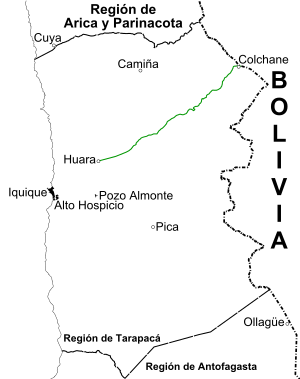
The Ruta 15 (short CH-15 ) is an international road in the Región de Tarapacá in the great north of Chile. In its 162.5 km route it connects the Ruta 5 , Huara and Iquique with the Paso Colchane-Pisiga border pass . This pass lies east of Colchane , on the border with Bolivia .
The road begins in Huara at the intersection with Ruta 5 and ends in the aforementioned border pass, from where you can continue on the Bolivian Ruta 12 to Oruro and La Paz . Customs control is 1 km before the border.
In addition to its tourist importance to the Volcán Isluga National Park , the road is known as the most expensive road in Chile, due to the high investments made in repairs and some sections with dangerous curves. It was built in the 1980s .
Cities and towns
The towns, villages and settlements along the section from west to east are:
Tarapacá region
- Length: 162 (km 0 to 162).
- Provincia del Tamarugal : Huara and police control (km 0), connection to Huarasiña and San Lorenzo de Tarapacá (km 23), connection to Pachica (km 33), connection to Mocha (km 56), connection to Usmagama (km 68), viewpoint Alto Chusmiza (km 72), connection to Chusmiza (km 74), viewpoint Chusmiza (km 81), Posada Huanca (km 117), Quebe (km 129), connection to Escapiña (km 155), connection to Cotasaya and Pisiga Choque ( km 155), connection to Isluga (km 156), Central Citani (km 158), Colchane (km 161), Pisiga Carpa (km 162).
Appointment to international road
On April 20, 2007, the then Minister of the MOP under the government of Michelle Bachelet , Eduardo Bitrán , signed the protocol for the extensive improvement work on the Ruta, while at the same time giving it the status of an international road . Since then it has been called Ruta 15-CH (previously it was the regional road A-55). Since then it has also been part of the Iquique - Oruro axis , the official function of which was ratified in 2007 by Decree Nº 126.
Individual evidence
- ↑ a b Red vial en la Región de Tarapacá en Dirección de Vialidad Chile ( Memento from August 31, 2011 in the Internet Archive ) (zip)
