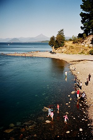
Lake Rupanco
| Lake Rupanco | ||
|---|---|---|

|
||
| Outflow of the Río Rahue from the lake | ||
| Geographical location | Región de los Lagos , Chile | |
| Drain | Río Rahue → Río Bueno → Pacific | |
| Location close to the shore | Entre Lagos and Piedras Negras | |
| Data | ||
| Coordinates | 40 ° 49 ′ S , 72 ° 29 ′ W | |
|
|
||
| surface | 223 km² | |
| Maximum depth | 350 m | |
| Middle deep | 70 m | |
Lago Rupanco is a lake in southern Chile .
It is located in Region X ( Región de los Lagos ), which is also called the Lakes Region. The lake is located between the towns of Puerto Octay and Entre Lagos .
Lake Rupanco has an area of around 223 km² (length approx. 45 km, width approx. 11 km) and an average depth of 70 m and a maximum of 350 m. The lake is an old glacial lake from the Ice Age . It is the source of the Rahue River .
The lake can be reached z. B. Across a street from Entre Lagos. The lake is a deep blue lake whose crystal clear water allows views up to 10 m deep. There are many bays and small beaches. In summer the water temperatures are between 9 and 18 ° C.
There is a rich flora and fauna. On plants these are z. B. myrtle plants and fuchsias . Many water birds, such as ducks and cormorants, live on the lake . The sea is very rich in fish. B. Trout and salmon .
Northeast of the lake is Antillanca , a field of volcanoes, cinder cones and maars.
history
German immigrants first settled the area around Lake Llanquihue from 1846 and came to Lake Rupanco, which is about 50 km north of Lake Llanquihue.
economy
Tourism, fishing and forestry play an important role in the area. The lake is ideal for sailing and fishing.
