Región del Maule
| Mouth VII. Region
del Maule |
|||
|---|---|---|---|
| Symbols | |||
|
|||
| Basic data | |||
| Country | Chile | ||
| Capital | Talca | ||
| surface | 30,296.1 km² | ||
| Residents | 1,044,950 (2017 census) | ||
| density | 34 inhabitants per km² | ||
| ISO 3166-2 | CL-ML | ||
| Website | goremaule.cl | ||
| politics | |||
| Intendant | Pablo Meza Donoso | ||
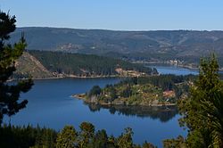
| Lago Vichuquén in the Maule region | |||
Coordinates: 35 ° 22 ′ S , 71 ° 44 ′ W
The Maule region is the VII region of Chile . It is located in central Chile and begins around 180 km south of the state capital Santiago de Chile . The southern border is around 50 km northeast of Concepción , the second largest city in Chile.
Geography and climate
In the north the region borders on the VI. Region ( Región del Libertador General Bernardo O'Higgins ) and in the south to the XVI. Region ( Región de Ñuble ). The capital of the Maule region is Talca .
The VII region consists of four provinces:
- Cauquenes , capital of Cauquenes
- Curicó , capital of Curicó
- Linares , capital of Linares
- Talca , capital Talca
Most important cities / places:
- Talca
- Curicó
- Linares
- Cauquenes
- Constitución
- Parral
Main river:
Numerous smaller rivers flow through the region, many of which are used to generate electricity. Maule is rural. There are extensive forests, pastures used by livestock farming and a lot of vegetable and fruit growing. Its wine-growing areas are particularly typical of the region. In the high mountains of the Andes , peaks around 4000 m belong to the region, many of which are volcanoes . The most famous volcanoes are the Peteroa (4125 m), the Descabezado Grande (3830 m) and the Descabezado Chico (3750 m).
The climate is Mediterranean with warm summers. The average temperatures are between 14 and 15 ° C.
history
Talca was founded in 1692 by Governor General Tomás Marín de Poveda. On February 17, 1742, the governor José Antonio Manso de Velasco gave it the name Villa San Agustín de Talca. Curicó followed in 1743, Linares and Parral in 1794.
In Talca is the house in which Bernardo O'Higgins signed the proclamation of the independence of Chile on February 12, 1818. It is now a museum.
Near Parral is the Colonia Dignidad , a notorious German settlement founded by the sect leader Paul Schäfer and which was used by the regime as a torture camp after the 1973 coup in Chile .
The great earthquake of February 27, 2010 hit the Maule region hard, with the tsunami disaster in Constitución in particular claiming many victims. The epicenter of the quake was in the Pacific Ocean off the coast of Maule.
tourism
The Maule region offers many excursion destinations for wine and horse lovers. In the east are the Andes with their thermal springs and smaller mountain lakes. Ski areas can also be found.
To the east is the national reserve Radal Siete Tazas with the Parque Inglés. A little to the south are the Altos de Lircay National Reserve and Parque Vilches . In the far north of the Pacific lies the Laguna Torca national reserve .
Around 50 km east of Talca in the area of San Clemente are the dammed lake Lago Colbún with 57 km² and the nature reserve Area de Protección Vilches .
economy
The Maule region is a large wine and fruit growing region. There are large rice-growing areas near Parral. Forestry is also important, as is the generation of energy from hydropower plants. In the area around Constitución there are a number of mining mines, where talc , quartz and sulfur are mined, among other things .
Web links
Individual evidence
- ↑ Massive earthquake strikes Chile bbc.co.uk, acceso 21 de april 2020 (ingés)
- ↑ Las producciones de vinos 2018 por Regiones Administrativas , accessed on August 5, 2018.


