Región de Coquimbo
| Coquimbo Region IV
Región de Coquimbo |
|||
|---|---|---|---|
| Symbols | |||
|
|||
| Basic data | |||
| Country | Chile | ||
| Capital | La Serena | ||
| surface | 40,579.9 km² | ||
| Residents | 757,586 (2017 census) | ||
| density | 19 inhabitants per km² | ||
| ISO 3166-2 | CL-CO | ||
| politics | |||
| Intendant | Claudio Ibáñez | ||
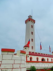
| La Serena lighthouse | |||
Coordinates: 29 ° 50 ′ S , 71 ° 10 ′ W
Region IV Coquimbo is the fifth northernmost region of Chile . It is located about 400 km north of Santiago de Chile .
In the north it borders on the Región de Atacama , in the south on the Región de Valparaíso and in the east on Argentina .
Geography and climate
The region is located in northern Chile on the Pacific. The capital La Serena is located about 470 km north of Santiago de Chile .
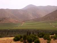
The region is dominated by desert landscapes, but there are also some fertile areas south of Coquimbo and near Ovalle . In the dry north z. B. the La Silla Observatory .
The main lifeline in the north is the Elqui River . In the middle there are several reservoirs (Recoleta, La Paloma and Cogoti). In the south, the Río Choapa donates the important water.
In many areas there is a desert-like climate with little rain. Usually the desert begins just behind the coastal cities, such as B. in La Serena .
history
The first human traces go back 10,000 years, e.g. B. Casa de Piedra a rock overhang near Ovalle.
The first city that the Spaniards founded in the Coquimbo region was La Serena . It is the second oldest city in Chile. Juan Bohón founded it on November 15, 1543 as a seaport connecting Santiago de Chile and Lima in Peru . However, the city was destroyed again on July 22, 1549 by attacks by the natives. Francisco de Aguirre practically re-founded on August 26, 1549.
The city of Coquimbo was used as a port in 1550, although it was not declared a city until 1867. Illapel followed in 1752 and the town of Ovalle in 1831.
The rich raw material deposits such as copper , iron and gold led to the region's strong upswing from 1840 onwards.
The region is repeatedly hit by severe earthquakes and tsunamis (e.g. 1801).
Administrative division
The region is divided into three provinces (north to south):
- Elqui Province
- Limarí Province
- Choapa Province
The biggest cities are:
- Coquimbo , 161,319 inhabitants (2005)
- La Serena , 154,523 inhabitants (2005)
- Ovalle , 112,956 inhabitants (2012)
- Illapel , 29,000 inhabitants (2005)
- Andacollo , 10,288 inhabitants (2002)
| province | Capital | Municipalities |

|
|---|---|---|---|
| Choapa | Illapel | 1 canela | |
| 2 Illapel | |||
| 3 Los Vilos | |||
| 4 Salamanca | |||
| Elqui | Coquimbo | 5 Andacollo | |
| 6 Coquimbo | |||
| 7 La Higuera | |||
| 8 La Serena | |||
| 9 Paihuano | |||
| 10 vicuña | |||
| Limari | Oval | 11 Combarbalá | |
| 12 Monte Patria | |||
| 13 oval | |||
| 14 Punitaqui | |||
| 15 Río Hurtado |
Attractions
The region has huge beach areas that are ideal for swimming and surfing. National parks such as the Bosque de Fray Jorge National Park or Las Chinchillas (National Park) are popular destinations. Excursions into the desert areas are also possible. The river valleys with their wine-growing areas are also worth a visit.
economy
The region has large deposits of iron and copper , as well as gold . In addition, agriculture is an important factor, in many river valleys wine (see also the article Viticulture in Chile ) and fruit are grown. Fishing, port management and tourism play an important role on the coast.


