Managua
| Managua | ||
|---|---|---|
|
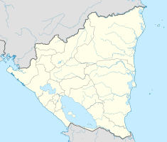
Coordinates: 12 ° 9 ′ N , 86 ° 16 ′ W Managua on the map of Nicaragua
|
||
| Basic data | ||
| Country | Nicaragua | |
| Department | Managua | |
| City foundation | 16th Century | |
| Residents | 1,033,622 (June 2016) | |
| - in the metropolitan area | 2,100,000 | |
| City insignia | ||
| Detailed data | ||
| surface | 267.17 km² | |
| Population density | 3851 inhabitants / km 2 | |
| height | 83 m | |
| City structure | 5 distritos | |
| Waters | Lake Managua | |
| Post Code | 10000-14338 | |
| prefix | +505 2 | |
| Time zone | UTC −6 | |
| City Presidency | Ing.José Dionisio Marenco Gutiérrez | |
| Website | ||
| Old Santiago Cathedral in Managua | ||
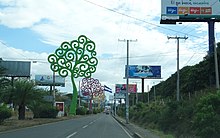
| Carretera a Masaya with a view of the Momotombo volcano | ||
| Managua | ||
Managua [ maˈnaːɡu̯a , Spanish maˈnaɣu̯a ] is the capital of the Central American state of Nicaragua and the administrative seat of the department of the same name .
Managua in nahuati means "where there is a large surface of water" and refers to the large lakes and lagoons of the capital, which stretch around 20 kilometers along the south bank of Lake Xolotlan ( Lake Managua ). The city has more than a million inhabitants (as of 2012), the metropolitan area even has 2.1 million inhabitants, mainly Spanish-speaking Creoles and whites. It is the largest city in Nicaragua and the second largest city in Central America after Guatemala City . The urban area has been destroyed several times by earthquakes. The worst destroyed over 90 percent of the building structure in 1972.
The archive of the national literacy campaign of Managua was in the list of 2007 world cultural heritage of UNESCO added.
geography
location
Managua is located at the southwest end of Lake Managua , also known as Lake Xolotlán . Since the city's sewage has been discharged directly and untreated into the lake since 1927, it is biologically as good as dead. The construction of a sewage treatment plant, whose construction Germany supported with 25 million euros, began in 2004. In 2009 the new sewage treatment plant, the largest in Central America, was inaugurated. The water quality is now better again. However, the lake is not clean: mountains of rubbish are still piling up on the shore, polluting the water with heavy metals.
The urban area of Managua is at an altitude of 55 m , the neighboring Sierras of Managua at an altitude of 970 m . There are four small lagoons within the city limits : The central one is the Tiscapa lagoon, which also contains a natural reservoir. The Asososca Lagoon in the west is the city's main drinking water reservoir. To the south of it is the Nejapa lagoon and in the north-west of the city is the Acahualinca lagoon.
geology
The earthquake of December 23, 1972 had a magnitude of 5.6 to 6.2.
climate
In Managua, as in most of western Nicaragua, apart from the Sierras , there is a tropical climate . The average annual temperature in Managua is 27.3 ° C. The temperatures are relatively constant between 28 and 32 ° C. The average annual precipitation is 1142 millimeters. Most of the precipitation falls in June and October with an average of 296 and 243 millimeters respectively, the lowest from December to April with an average of less than ten millimeters.
| Managua | ||||||||||||||||||||||||||||||||||||||||||||||||
|---|---|---|---|---|---|---|---|---|---|---|---|---|---|---|---|---|---|---|---|---|---|---|---|---|---|---|---|---|---|---|---|---|---|---|---|---|---|---|---|---|---|---|---|---|---|---|---|---|
| Climate diagram | ||||||||||||||||||||||||||||||||||||||||||||||||
| ||||||||||||||||||||||||||||||||||||||||||||||||
|
Average monthly temperatures and rainfall for Managua
Source: BBC Weather ; wetterkontor.de
|
|||||||||||||||||||||||||||||||||||||||||||||||||||||||||||||||||||||||||||||||||||||||||||||||||||||||||||||||||||||||||||||||||||||||||||||||||||||||||||||||||||||
Population development
The city's population development since the 1971 census.
| year | population |
|---|---|
| 1971 census | 384.904 |
| 1995 census | 864.201 |
| 2005 census | 908.892 |
| 2016 estimate | 1,033,622 |
history
Pre-Columbian history
The first footprints of Paleo-Indians date back to around 6000 BC. They were found near the beaches of Lake Managua as early as 1872. Other archaeological traces were found in the form of ceramic remains and statues made from volcanic rock on the Zapatera Island. The petroglyphs of the Ometepe Island also date to the pre-Columbian period.
Since the 16th century

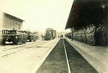
The city was founded in the 16th century and has been the country's capital since 1858. Since it was largely destroyed by earthquakes several times , the city looks like a huge village from above. For example, it was destroyed in 1931. The earthquake of December 23, 1972 with a magnitude of 6.2 also cost 5,000 lives. Then an attempt was made to completely rebuild the city around the old center, today's area monumental , in which the ruins of the cathedral, the national palace, the Ruben Dario theater and the new presidential palace are located.
During a banquet in Managua, to which President Sacasa had invited Sandino and his officers on February 21, 1934 , they were murdered by the National Guard Anastasio Somoza Garcías .
Hurricane Mitch wreaked havoc in 1998.
Apparently a meteorite caused a crater with a diameter of 12 m and a depth of 5.5 m in a forest near the airport on September 7, 2014 (?). The hurling of dust was observed by neighbors, there was a smell of burned food, two waves were detected on the seismometer from impact and bang . Hundreds of people left their homes for fear of an earthquake. As no fireball was observed, NASA questions the theory of a meteorite fall.
Culture and sights
- Plaza de la Revolución
The Plaza de la Revolución is the former Plaza de la República .
- Santiago de Managua Cathedral
- Rubén Darío National Theater
The Rubén Darío National Theater is the most important theater in Nicaragua and one of the most modern in Central America. The National Theater is one of the few buildings that was spared the 1972 earthquake that destroyed 90 percent of Managua.
- Hotel Crowne Plaza Managua (from 1969 to 1992 Hotel Intercontinental Managua)
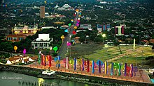
The Crowne Plaza (pictured on the panoramic picture below rear left and right) in 1969 as Hotel Intercontinental Managua (still popular El Inter called) built and is still due to its on a Maya - Temple Pyramid ajar architecture one of the landmarks of Managua.
- Dennis Martínez National Stadium
The Dennis Martínez National Stadium was the largest stadium in Central America when it was built in 1948. It survived the 1972 earthquake undamaged. The number of seats is around 30,010. It is named after Dennis Martínez , who became the first Nicaraguan to play Major League Baseball .
- Banam skyscraper (now the Benjamín Zeledón building )
Economy and Infrastructure
In a ranking of cities according to their quality of life, Managua ranked 173rd out of 231 cities worldwide in 2018. For comparison: Guatemala's capital Guatemala City was 158th, Hondura's capital Tegucigalpa was 189th and El Salvador's capital San Salvador was 179th.
traffic
In terms of transportation, Managua is one of the best connected cities in Nicaragua. All of the country's main routes lead to Managua. There are good public connections between most other cities and the capital. Four highways lead to Managua: The Pan-American Highway connects Managua in the north to the northern and central departments of Nicaragua. The southern highway (Southern Highway) , the southern part of the Pan-American highway, connects Managua with the southern departments such as Carazo and Rivas. Other highways lead to the departments of Masaya and Granada as well as to León. The infrastructure is comparatively well developed in Nicaragua. Compared to other Central American countries, there are only a few impassable roads.
There are 35 bus routes in Managua. These are regulated by the regulatory authority for urban transport (IRTRAMMA) and are operated by different cooperatives and companies. In addition, there are two bus routes that used to lead to suburbs, but which have now excluded the growing capital (Esquipulas and Los Vanegas). And seven bus routes connect the city with the nearby Ciudad Sandino. Buses are the cheapest means of transport in Managua and are used a lot. A map of these 44 bus routes was created and published by the Nicaraguan OpenStreetMap in early 2016 in a crowdsourcing initiative.
The city's airport is named Managua International Airport or Aeropuerto Internacional Augusto C. Sandino ( IATA code : MGA ; ICAO code : MNMG ), named after the resistance fighter Augusto César Sandino .
education
Managua is home to the Universidad Centroamericana and other universities, the National Archives, the National Library and the National Museum. The Central American Court of Justice is also located here.
The library of a primary school in Managua bears the name of the German writer Käthe Kollwitz , due to the partnership between this primary school and the Käthe Kollwitz comprehensive school in Langenselbold .
Archdiocese
The city has been the seat of the Archdiocese of Managua since 1913 . After the old Santiago Cathedral was badly damaged by the 1972 earthquake, a new cathedral was built from 1991-1993 based on the plans of the Mexican architect Ricardo Legorreta . The Catedral Metropolitana Inmaculada Concepción de María is the new main church of the Archdiocese.
Town twinning
Managua is twinned with the following cities:
|
|
Personalities
sons and daughters of the town
- Fernando Bernabé Agüero Rocha (1920–2011), politician
- Rolando José Álvarez Lagos (* 1966), Roman Catholic bishop
- Alexis Argüello (1952-2009), boxer
- Arnoldo Alemán (* 1946), President of Nicaragua from 1997 to 2002
- Gioconda Belli (* 1948), writer
- Luis Abraham Delgadillo (1887–1961), composer
- Juan José Estrada (1872–1947), former President of Nicaragua
- Roman Gonzalez (born 1987), boxer
- Carlos Enrique Herrera Gutiérrez (* 1948), Roman Catholic bishop
- Bianca Jagger (* 1945), American human rights activist
- Juan Abelardo Mata Guevara (* 1946), religious priest and Roman Catholic bishop
- Ricardo Mayorga (* 1973), boxer
- Lillian Molieri Bermúdez (1925–1980), actress
- Karla Moreno (* 1988), weightlifter
- Luis Alberto Pérez (* 1968), boxer
- Claudia Poll (* 1972), Costa Rican swimmer
- Samuel Santos López (* 1938), politician
- René Schick Gutiérrez (1909–1966), President of Nicaragua 1963–1966
- José Carlos Solórzano Gutiérrez (1860–1936), President of Nicaragua from 1925 to 1926
- Joaquín Zavala (1835–1906), President of Nicaragua 1879–1883 and 1893
- José Santos Zelaya (1853–1919), politician and President of Nicaragua from 1893 to 1910
Personalities who have worked on site
- Nora Astorga (1948–1988), lawyer, politician and judge
- Barbara Carrera (* 1945), American actress and model
- Roberto Martínez Lacayo (1899–1984), Minister of Defense of Nicaragua from 1970 to 1974
- Jörn Bleck-Neuhaus (* 1942), German nuclear physicist and professor
Web links
- Managua.gob.ni Website of the City of Managua
- Map of Managua
- “Laughing on the Plaza Colón” , Tagesspiegel , November 9, 2008, report
- Documentary film recordings of the consequences of the 1931 earthquake on the British Pathé on April 16, 1931, Title: A City Wiped Out ... Thousands dead! [2]
- Recuerdos inolvidables de Managua 1940-1950 (Unforgettable memories of old Managua), documentary film recordings from the late 1940s on youtube.com, length: 10 min.
- Animation of the old city center of Managua before the earthquake by Alfredo Osorio Peters on youtube.com
- Animation of the old city center of Managua before the earthquake by arte & color on youtube.com
Individual evidence
- ↑ [1]
- ^ Statistical Yearbook of Nicaragua, page 6, Area of Cities and Towns
- ↑ Entry at UNESCO ( Memento of the original dated August 5, 2009 in the Internet Archive ) Info: The archive link was inserted automatically and has not yet been checked. Please check the original and archive link according to the instructions and then remove this notice.
- ↑ On the geology of Managua
- ^ Nicaragua: Departments & Cities - Population figures in maps and tables. Retrieved March 10, 2018 .
- ↑ Footprints of Acahualinca (Eng.)
- ^ Time, Mar. 05, 1934 Murder at the Crossroads
- ↑ http://orf.at/#/stories/2244806/ Apparently meteorite impact in Nicaragua, ORF.at from September 8, 2014
- ↑ http://orf.at/#/stories/2244949/ NASA doubts meteorite impact, ORF.at of September 9, 2014
- ↑ Mercer's 2018 Quality of Living Rankings. Retrieved August 18, 2018 .
- ^ Rutas de Managua y Ciudad Sandino . MapaNica.net - OpenStreetMap Nicaragua. Retrieved February 9, 2016.
- ^ The true geographers take the bus . confidencial.com.ni. Retrieved February 9, 2016.
- ↑ Website of the City of Managua ( Memento of the original from April 9, 2015 in the Internet Archive ) Info: The archive link was automatically inserted and not yet checked. Please check the original and archive link according to the instructions and then remove this notice.


