
Curitiba
| Município de Curitiba "Cidade Modelo"
Curitiba
"Cidade Ecológica do Brasil" "Capital das Araucárias" |
|||
|---|---|---|---|
 Aerial photograph; Paço da Liberdade at Praça Generoso Marques; Palácio Avenida with Rua das Flores ; Rua 24 Horas ; Museu Oscar Niemeyer and Jardim Botânico .
|
|||
|
|||
| Coordinates | 25 ° 26 ′ S , 49 ° 16 ′ W | ||
| Symbols | |||
|
|||
| founding | March 29, 1693 | ||
| Basic data | |||
| Country | Brazil | ||
| State | Paraná | ||
| ISO 3166-2 | BR-PR | ||
| Região intermediária | Curitiba (since 2017) | ||
| Região imediata | Curitiba (since 2017) | ||
| Metropolitan area | Curitiba metropolitan area | ||
| structure | 10 administrative regions | ||
| height | 934 m | ||
| climate | Maritime climate , cfb | ||
| surface | 435 km² | ||
| Residents | 1,751,907 (2010) | ||
| density | 4027 Ew. / km² | ||
| estimate | 1,933,105 (July 1, 2019) | ||
| Parish code | IBGE : 4106902 | ||
| Post Code | 80000-000 to 87999-999 | ||
| Telephone code | (+55) 41 | ||
| Time zone | UTC −3 | ||
| Website | curitiba.pr (Brazilian Portuguese) | ||
| politics | |||
| City Prefect | Rafael Greca (2017-2020) | ||
| Political party | PMN | ||
| Culture | |||
| Patron saint | Our Lady of Light | ||
| City festival | March 29th (foundation festival) | ||
| economy | |||
| GDP | 83,788,904 thousand R $ 44,239 R $ per person (2016) |
||
| HDI | 0.823 (2010) | ||


Curitiba [ kuɾiˈtʃibɐ ], officially Portuguese Município de Curitiba , is a city in Brazil and the capital of the state of Paraná . With over 1.9 million inhabitants, Curitiba is the eighth largest city in Brazil. It is the core of the metropolitan region of Curitiba , in which around 3.6 million people live.
Toponymy
The name Curitiba comes from the Tupí-Guaraní languages . The exact etymology , however, is controversial, depending on whether the word components are derived from the Tupi language ( curi = "pine" and tiba = "many") or the Guaraní language . There was a controversy about this in the 20th century. The name means "land with many araucarias ".
history
The Portuguese , who founded the city in 1693, named it Vila Nossa Senhora da Luz e Bom Jesus dos Pinhais . The name was changed to Curitiba as early as 1721 .
Curitiba officially became a city in 1842. Their growth was based on trade, especially cattle trading. In 1854 Curitiba became the capital of Paraná . A phase of rapid development followed in which schools and theaters were built.
From 1870 onwards, many European immigrants , mainly Germans , Poles , Ukrainians and Italians , immigrated to Curitiba. Smaller numbers of French , British and Swiss immigrants also established colonies near the city, mainly devoting themselves to agriculture and traditional crafts.
From 1915 to 1924, many Japanese , Lebanese and Syrians also immigrated to Curitiba.
In 1913 the first federal university was founded with the Universidade Federal do Paraná , and in the same year the horse-drawn tram was electrified.
Population development of the city
| year | population |
|---|---|
| 1872 | 12,651 |
| 1890 | 24,553 |
| 1900 | 49,755 |
| 1920 | 78,986 |
| 1940 | 140,656 |
| 1950 | 180,575 |
| 1960 | 361,309 |
| 1970 | 642,362 |
| 1980 | 1,052,147 |
| 1991 | 1,313,094 |
| 2000 | 1,586,848 |
| 2010 | 1,751,907 |
| 2019 | 1,933,105 |
geography
Geographical location
Curitiba is located on the first Paranaensian plateau , the Primeiro Planalto Paranaense , inland about 90 kilometers from the port of Paranaguá . According to the 2010 census, it has 1,751,907 inhabitants, who are called curitibanos (Curitibans) in Portuguese . As of July 1, 2018, the IBGE estimated the population to be 1,917,185. The geographical coordinates are 25.42 ° south latitude and 49.29 ° west longitude, the height above sea level is 934 meters.
Curitiba is the seat of the Metropolitan Metropolitan Region of Curitiba (RMC), established in 1973 , to which 29 cities belong (2015 estimate: 3,502,804 inhabitants). It is the eighth largest of the Brazilian megacities.
climate
|
Average monthly temperatures and rainfall for Curitiba
Source: wetterkontor.de
|
||||||||||||||||||||||||||||||||||||||||||||||||||||||||||||||||||||||||||||||||||||||||||||||||||||||||||||||||||||||||||||||||||||||||||||||||||||||||||||||||||||||||||||||||||||||||
urban planning
The city of Curitiba is known in specialist circles for its efficient transport system with its own bus lanes on the main roads. Are used double articulated buses whose stops are enhanced tubes with access for the disabled are provided. The system, which is used by 85% of Curitiba's population, served as a model for the TransMilenio in Bogotá ( Colombia ). The city has also been successful in maintaining green spaces and boasts of having 54 square meters of green space per inhabitant.
The city also started another interesting project: under the name “Faróis do Saber” (lighthouses of knowledge) freely available educational centers such as libraries , internet access and other cultural institutions were opened. Lighthouses were actually added to the buildings of these facilities in order to make them widely recognizable.
Today Curitiba is considered to be one of the world's best examples of good urban planning. In June 1996 Curitiba was honored as the “ most innovative city in the world” at the congress of urban planners in Istanbul .
Tourist destinations (selection)
- Torre Panorâmica (observation tower, also used by Brasil Telecom for telecommunications purposes)
- District Santa Felicidade known for its gastronomy,
- Oscar Niemeyer Museum (MON)
- Passeio Público Park
- Parque Tanguá , artificially created park landscape
- Botanical Garden (Jardim Botânico)
- Ópera de Arame ( Wire Opera House )


Torre
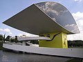
Oscar Niemeyer Museum

Ópera


Archdiocese of Curitiba
Curitiba has been the seat of a Roman Catholic diocese since 1892, which became the Archdiocese of Curitiba in 1926 . The Ukrainian Greek Catholic Church has had the São João Batista em Curitiba Archeparchy in Curitiba since 1971 .
Sports
Curitiba has 3 major football clubs:
- Coritiba FC (1909): Brazilian champion 1985, currently in the Série B.
- Athletico Paranaense (1924): Brazilian champion 2001, currently in the Série A.
- Paraná Clube (1989): currently in the Série B
The Arena da Baixada was the venue for four first-round matches of the 2014 World Cup .
Beach volleyball player Emanuel Rego , Olympic champion and two-time world champion , was born in Curitiba .
Curitiba has owned a motorsport race track since 1967 , which was expanded and modernized in the 1990s. The Autódromo Internacional de Curitiba is one of the most modern racetracks in the country. The 2008 World Touring Car Championship began on March 2, 2008 in Curitiba.
In 2002 the 3rd women's fistball world championship took place in Curitiba , and in 2016 the 7th women's fistball world championship .
Economy and Infrastructure
Companies
In addition to Siemens and Robert Bosch GmbH, there are other plants of the automobile manufacturers Volkswagen do Brasil , Renault-Nissan and Volvo in neighboring São José dos Pinhais . An oil refinery also produces on site. Curitiba's economy particularly benefits from the Paranaguá port, which is only around 70 kilometers away . The Brazilian computer manufacturer Positivo is also based in Curitiba.
The German-Brazilian Chamber of Industry and Commerce has a branch in Curitiba. The daily newspaper Tribuna do Paraná is published in Curitiba. Music Online Records is one of the oldest and largest music portals in Brazil, based in the Sao Francisco district. It has been online since April 18, 1998.
traffic
By the 1960s, Curitiba's population had grown to 430,000. It was feared that the increase in population would drastically change life in the city. In 1964, Mayor Ivo Arzua asked for proposals for town planning. The architect Jaime Lerner , who later became mayor and later governor, led a group from the Federal University of Paraná State , which proposed strict control of urban expansion, reduced traffic in the city center, preserve Curitiba's historical heritage and unified it to build convenient and generally affordable public transport. This plan was adopted in 1968. Lerner closed Rua XV de Novembro - one of the main thoroughfares - for car traffic and applied a new road design to reduce traffic. This design, called the Triple Street System , consists of two one-way streets that run in opposite directions and surround a smaller, two-lane street.
Local public transport

In the 1980s, the “integrated transport network” Rede Integrada de Transporte was completed. It allows you to travel to any point in the city for a single fare.
A special feature in Curitiba are the stop tubes with elevated platforms, which were set up at all stops with Linha Direta or Expresso Biarticulado service. These are always manned by staff who carry out the time-consuming ticket sales and ticket inspection at the entrance to the tube, so that the vehicle only needs very short stopping times for the actual passenger change. This effect is reinforced by the elevated platforms, which allow boarding and alighting at the same level without steps. This enables an exceptionally high travel speed to be achieved with the high-floor buses.
The following series of pictures shows the more precise process of such a passenger change:

The network of bus lines was strictly hierarchized, so that today there are ten different products, each with specific transport tasks:
- Circular Centro (white painted minibuses ): single ring line to develop the central city area
- Convencional (small and normal buses painted yellow): connecting lines between the city districts
- Troncal (yellow painted normal and articulated buses ): connecting lines between the districts that integrate with other lines
- Interhospitais (small and normal buses painted white): single ring line between some hospitals
- Alimentador (orange painted normal and articulated buses): feeder lines to the Interbairros , the Diretas and the Expressos
- Madrugueiro (normal and articulated buses painted yellow): connecting lines thatoperateafter midnight
- Interbairros (dark green painted normal and articulated buses): six ring lines between the city districts
- Linha Turismo (white painted normal buses and light green painted double-decker buses ): single ring line between tourist destinations in the city
- Linha Direta (silver-painted (articulated) high-floor buses): these form an express bus network that connects the city's major transfer points without intermediate stops - the buses have their entry doors on the left side of the vehicle, as a bus stop tube can also be approached from the right and a direct oneYou canchange at the same bus platform through the tube to the opposite bus
- Expresso (red-painted articulated and double-articulated high-floor buses): a high-performance network of lines crossing the city, which has the character of a " light rail system on tires " and runs for the most part on its own bus routes that are independent of the rest of the car traffic
- Ligeirão (double-articulated high-floor buses painted blue or red): faster Expresso lines that leave out some stops
- SITES (blue painted normal buses): special school transport for children with disabilities
- Acesso (gold painted minibuses): special transport for other people with disabilities.
Long-distance transport
Airport
There are four airports in Curitiba, the main one is in São José dos Pinhais south of the city center Afonso Pena International Airport (IATA: CWB, ICAO: SBCT). Some national and international destinations are served. Commercially oriented flights in the region are all handled through this airport.
Trunk roads
Curitiba has connections to major cities in Brazil via the BR-116, BR-376/101, BR-277, BR-476 and BR-153 motorways. For example, the São Paulo - Rio Grande do Sul highway runs through the urban area.
Rodoferroviária
The Rodoferroviária corresponds to what is best described in the German-speaking area as the “central bus station”. The bus connections that start from Curitiba or run through the city allow bus trips to destinations that are significantly more than 1000 kilometers away (e.g. Recife or Rio de Janeiro). Mostly comfortable intercity coaches are used.
.JPG)
Railway lines
A passenger train network does not exist, not even in local transport. However, the city has access to rail freight transport. However, the Serra Verde Express for tourists connects Curitiba with Morretes every day . On Sundays he goes to the port of Paranaguá . Historically, from 1885 to 1972, the Estrada de Ferro Paraná (EFP) railway line, which was opened in the German Empire as the first railway in the state, ran between Curitiba and the port city of Paranaguá.
Town twinning
-
 Krakow , Poland
 -
 Guadalajara , Mexico
 -
 Himeji , Japan
 -
 Orlando (Florida) , USA
 -
Jacksonville (Florida) , USA
-
 Coimbra , Portugal
sons and daughters of the town
literature
- Rosane M. Zanini: urban development, urban planning, favelas. Development problems in a capital city: The example of Curitiba in the state of Paraná (southern Brazil). Lang, Bern 2005, ISBN 3-03910-356-3 .
- Klaus Frey: Democracy and environmental protection in Brazil. Sustainable development strategies in Santos and Curitiba. LIT Verlag, Berlin / Hamburg / Münster 1997, ISBN 3-8258-3428-X .
Web links
- Literature by and about Curitiba in the catalog of the Ibero-American Institute of Prussian Cultural Heritage, Berlin
- Website of the City of Curitiba (Portuguese, Spanish, English)
- Website of the City Chamber of Curitiba (Portuguese)
- IPPUC website - Instituto de Pesquisa e Planejamento Urbano de Curitiba , City Planning Office (Portuguese)
- Curitiba-Parana.de Useful information about Curitiba (German)
Individual evidence
- ^ A b Instituto Brasileiro de Geografia e Estatística (IBGE): Curitiba - Panorama. Retrieved August 24, 2019 (Brazilian Portuguese).
- ↑ Euclides Lucas Garcia: Rafael Greca é eleito prefeito de Curitiba. In: Gazeta do Povo, October 30, 2016 [accessed November 3, 2016] (Brazilian Portuguese).
- ↑ Jurandyr Pires Ferreira: ENCICLOPEDIA dos Municipios Brasileiros. Instituto Brasileiro de Geografia e Estatística, Rio de Janeiro 1959, Volume 31, p. 204.
- ↑ Eduardo de Almeida Navarro: Dicionário de tupi antigo. A língua indígena clássica do Brasil. Global Editora, São Paulo 2013, ISBN 978-85-260-1933-1 , p. 559.
- ↑ BORUSZENKO, Oksana (UFPR): A imigração ucraniana no Paraná. (PDF; 1.3 MB) Retrieved October 10, 2013 (Portuguese).
- ↑ IBGE Censo 2010: Tabela 1.6 - População nos Censos Demográficos, segundo os municípios das capitais - 1872/2010. In: censo2010.ibge.gov.br. Instituto Brasileiro de Geografia e Estatística (IBGE), accessed August 24, 2019 (Brazilian Portuguese).
- ↑ IBGE : Cidades @ Paraná: Curitiba - Panorama. July 1, 2018, accessed October 14, 2018 .
- ↑ IBGE: Estimativas da população dos municípios e unidades da Federação Brasileiros com data de referencia em 1 ° de julho de 2015. Accessed on 6 September 2016 .
- ^ Arena da Baixada, in Curitiba, stadium of the World Cup 2014. In: aboutcuritiba.com. 2014, archived from the original on August 19, 2014 ; accessed in March 2018 (English).
- ↑ LifePR : The fight for the World Touring Car Championship begins for BMW in Curitiba on March 3, 2009.
- ↑ Manager Magazin : Cities of the Future - Curitiba in Brazil from June 9, 2005.
- ↑ German-Brazilian Chamber of Commerce and Industry Curitiba branch
- ↑ Serra Verde Express. In: com.br. 2012, archived from the original on January 17, 2012 ; Retrieved March 19, 2018 (Portuguese).
- ↑ RVPSC - Curitiba-Paranaguá on the Estações Ferroviárias do Brasil website , accessed on March 23, 2016 (Portuguese).