Guarulhos
| Guarulhos | ||
|---|---|---|
|
Coordinates: 23 ° 28 ′ S , 46 ° 32 ′ W Guarulhos on the map of Brazil
|
||
| Basic data | ||
| Country | Brazil | |
| State | São Paulo | |
| City foundation | December 8, 1560 | |
| Residents | 1,176,804 (2010) | |
| City insignia | ||
| Detailed data | ||
| surface | 318.014 | |
| Population density | 4022.47 inhabitants / km 2 | |
| height | 759 m | |
| Post Code | 07010-07274 | |
| Time zone | UTC −3 | |
| City Presidency | Gustavo Henric Costa ( PSB ), since 2016 | |
| Website | ||
| Guarulhos | ||
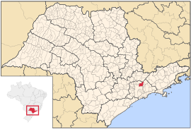
| Guarulhos in the state of São Paulo | ||
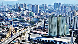
Guarulhos [ ɡwaˈɾuʎus ] is a municipality in the state of São Paulo in Brazil . It had 1,176,804 inhabitants (as of 2010) on an area of 318.014 km². The population density is 4,022.47 inhabitants / km². Guarulhos is part of the São Paulo metropolitan area and borders the city of São Paulo to the south and west , Mairiporã , Nazaré Paulista and Santa Isabel to the north and Arujá and Itaquaquecetuba to the east .
In the city there is the Universidade Guarulhos , a state-recognized university.
The São Paulo-Guarulhos International Airport (GRU), the largest in South America, is located on the city's territory .
Toponymy
The name comes from the Tupi language . The origin probably lies in the self-name of the Guaramomi tribe who used to live here.
history
The place was founded in 1560 by the Jesuit Manuel de Paiva . The municipality received city rights on March 24, 1880.
In 1981 the Roman Catholic diocese of Guarulhos was established in the city . The Church of Nossa Senhora da Conceição , built in 1685, was elevated to the status of a cathedral .
sons and daughters of the town
- Marques Batista de Abreu (* 1973), football player
- Juninho Bill (* 1977), singer and music producer, former soccer player
- Cristiano Marques Gomes ( Cris , born 1977), football player
- José Mota (* 1979), soccer player, 2010 top scorer in the Asian Champions League
- Rubinho (* 1982), soccer goalkeeper
- Rafinha (born 1983), football player
- André Vasco (* 1984), TV presenter
- Wellington Santos da Silva (born 1985), football player
- PC Siqueira (* 1986), moderator, blogger and illustrator
- Evandro Silva do Nascimento (* 1987), football player
- David Braz de Oliveira Filho (* 1987), football player
- Pedro Sakamoto (* 1993), tennis player
- Jefferson Andrade Siqueira (* 1988), Brazilian-Italian soccer player
- Henrique Dourado (* 1989), football player
- Marcelino Junior Lopes Arruda (* 1989), football player
- Samuel Nascimento (* 1990), actor, singer and dancer
- Jaimerson da Silva Xavier (* 1990), football player
- Bruno Dybal (* 1994), football player
- Gabriel Martinelli (* 2001), football player
- Diego Oliveira Silva (* 1990), football player.
Web links
- Encontra Guarulhos (Brazilian Portuguese)


