Tumbes
| Tumbes | ||
|---|---|---|
|
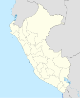
Coordinates: 3 ° 34 ′ S , 80 ° 27 ′ W Tumbes on the map of Peru
|
||
| Basic data | ||
| Country | Peru | |
| region | Tumbes | |
| province | Tumbes | |
| City foundation | 1532 | |
| Residents | 96,946 (2017) | |
| City insignia | ||
| Detailed data | ||
| height | 6 m | |
| Waters | Río Tumbes | |
| City Presidency | Carlos Jimy Silva Mena | |
| Website | ||
| Tumbes Cathedral | ||
Tumbes is a city with 96,946 inhabitants (2017 census) in the northwest of the South American Andean state Peru . It is located in the same district Tumbes Province Tumbes , whose capital it is. Tumes is also the administrative center of the Tumbes region of the same name .
The city has an airport that is served from Lima .
Tumbes is located on the lower reaches of the Río Tumbes not far from its confluence with the Gulf of Guayaquil ( Pacific ). Tumbes is about 10 km from today's border between Peru and Ecuador and was one of the most important scenes of the border disputes in the Peruvian-Ecuadorian war in July 1941. The former Ecuadorian department Tumbes was in the protocol of Rio de Janeiro of January 29, 1942 as a result of Awarded the Battle of Zarumilla (June 23-25, 1941) to the territory of Peru.
Individual evidence
- ^ Peru: Tumbes Region - Provinces & Places . www.citypopulation.de. Retrieved December 23, 2019.


