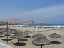
Chala (altitude level)
The Chala (from Aymara ch'alla , "sand") is the lowest altitude level west of the Andes , according to Javier Pulgar Vidal , from sea level to 500 m above sea level . Together with the Omagua level on the east side of the Andes, they form the planar elevation level and are part of the classic Andean zoning Tierra caliente ("hot land")
The surface relief of the Chala is varied: mountain ridges that reach into the sea alternate with flat, sandy sections and dunes, so that in places there is a coastline rich in bays.
The Chala is a desert landscape, interrupted by very fertile river valleys, the rivers of which are partly only temporary and which enabled the ancient high cultures such as the Mochica or later the Chimú to have a very productive agriculture. Today cotton , rice , sugar cane , wine and olives are grown there on an industrial scale .
In the north of Peru the climate is hot and sunny with occasional seasonal rains. In the south of Peru the sun shines from December to May, while otherwise fog prevails and practically no rain falls. Despite the lack of rain, the relative humidity is comparatively high.
Due to the cold Humboldt Current and the high western mountain range of the Andes, the climate is cooler and much drier than that in other regions of the world at comparable latitudes. At the same time, there are hardly any fluctuations in air pressure.
There are regionally diverse plant communities in the Chala . The most important (partially introduced) plants include the American carob tree ( Prosopis pallida , a Mesquite species), e.g. B. sedge , totora , coconut palms , date palms , olive trees and grapevines used for mats, baskets, boxes .
literature
- Javier Pulgar Vidal: Geografía del Perú. Las Ocho Regiones Naturales del Perú, la regionalizacion transversal, la microregionalizacion. 10th edition. Peisa, Lima 1996, ISBN 9972-40-027-3 (first edition 1946).
