
Egliswil
| Egliswil | |
|---|---|
 |
|
| State : |
|
| Canton : |
|
| District : | Lenzburg |
| BFS no. : | 4195 |
| Postal code : | 5704 |
| UN / LOCODE : | CH EGL |
| Coordinates : | 656 493 / 244602 |
| Height : | 459 m above sea level M. |
| Height range : | 412–666 m above sea level M. |
| Area : | 6.29 km² |
| Residents: | 1477 (December 31, 2019) |
| Population density : | 235 inhabitants per km² |
|
Proportion of foreigners : (residents without citizenship ) |
13.7% (December 31, 2019) |
| Website: | www.egliswil.ch |
 Egliswil, seen from Seon |
|
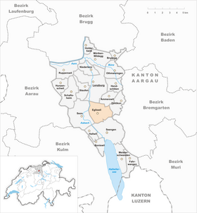
| Location of the municipality | |
  |
|
Egliswil ( ˌɛɡliʃˈʋiːl in the local dialect ) is a municipality in the Swiss canton of Aargau . It belongs to the Lenzburg district and is four kilometers south of the district capital in the Seetal .
geography
The clustered village is set back a little on the eastern edge of the Seetal in the middle of a gently sloping hollow between the hills Häbni ( 531 m above sea level ), Birch ( 591 m above sea level ) and Emmet ( 577 m above sea level ). To the northeast of the village, the hollow merges into the narrow tribach valley. This body of water bears the name Lenzburger Stadtbach in the further course and flows into the Aabach near the district capital . To the east of the Tribachtal rises the Rietenberg hill chain, the natural border to the Bünztal . To the west and south of the village, the terrain is largely flat.
The area of the municipality is 629 hectares , of which 252 hectares are forested and 59 hectares are built over. The highest point is at 664 meters in the Grossmoos on the Rietenberg chain, the lowest at 415 meters on the Aabach. Neighboring communities are Lenzburg in the north, Ammerswil in the northeast, Dintikon and Villmergen in the east, Seengen in the south and Seon in the west.
history
A single grave with ceramic objects from the second half of the 2nd century discovered in 1953 suggests the existence of a Roman manor. Its exact location is not yet known. Egirichiswilare was first mentioned in a document in 893 in an interest toboggan run by the Fraumünster in Zurich . The place name comes from the Old High German Egiricheswilari , which means "Hofsiedlung des Egirich". In the Middle Ages the village was under the rule of the Counts of Lenzburg , from 1173 on that of the Counts of Kyburg . After these died out, the Habsburgs took over sovereignty and blood jurisdiction in 1273 . In 1331 they pledged the lower jurisdiction permanently to the Lords of Hallwyl .

In 1415 the confederates conquered Aargau. Egliswil now belonged to the subject area of the city of Bern , the so-called Bernese Aargau . The village was initially part of the Seengen judicial district in the Lenzburg district and was raised to the status of its own judicial authority in 1677. In 1528 the Bernese introduced the Reformation . In 1563 the Hallwylers renewed the Egliswil opening . Fires in 1593, 1697 and 1731 destroyed large parts of the village. In March 1798 the French took Switzerland, ousted the «Gracious Lords» of Bern and proclaimed the Helvetic Republic . Egliswil has been part of the canton of Aargau since then.
In 1816, 1824, 1846 and 1855 numerous houses again went up in flames, which resulted in the disappearance of the original farmhouses. The first school was built in 1828 and electric light was introduced in 1911. Egliswil remained an agricultural village well into the 20th century . In addition to the cultivation of grain, viticulture also played a central role, but the vines disappeared around 1900 due to the phylloxera epidemic. Egliswil was once one of the largest villages in the Seetal, but between 1850 and 1950 the population decreased by over a third. Since the beginning of the 1980s, however, there has been significant growth due to intensive construction activity.
Attractions

The church of Egliswil is a branch of the parish Seengen . The relatively small hall church , originally built in the Romanesque style, received Gothic elements around 1500 . In 1583 a tower was added on the west side. The Haus zum Sonnenberg was built from stone in 1694 and served as the residence of the Egliswil Untervogts.
coat of arms
The blazon of the municipal coat of arms reads: "In blue three crossed white fish, accompanied by three five-pointed white stars." The coat of arms, which was first used on the community seal in 1811, goes back to a misinterpretation of the place name. The Alemannic Egirichswilare refers to the settlement of the Egirich (the "fearful and terrifying kingdom"), so has nothing to do with perch (Swiss German: Egli ). In 2003 the six-pointed stars were replaced by five-pointed ones.
population
The population developed as follows:
| year | 1850 | 1900 | 1930 | 1950 | 1960 | 1970 | 1980 | 1990 | 2000 | 2010 |
| Residents | 1146 | 849 | 779 | 706 | 704 | 708 | 722 | 900 | 1210 | 1318 |
On December 31, 2019, 1477 people lived in Egliswil, the proportion of foreigners was 13.7%. In the 2015 census, 52.4% described themselves as Reformed and 16.7% as Roman Catholic ; 30.9% were non-denominational or of other faiths. In the 2000 census, 96.1% said their main language was German , 0.8% Serbo-Croatian and 0.7% Italian .
Politics and law

The assembly of those entitled to vote, the municipal assembly , exercises legislative power. The executing authority is the five-member municipal council . He is elected by the people in the majority procedure, his term of office is four years. The parish council leads and represents the parish. To this end, it implements the resolutions of the municipal assembly and the tasks assigned to it by the canton. The District Court of Lenzburg is the first instance responsible for legal disputes . Egliswil belongs to the Friedensrichterkreis XII (Seon).
economy
According to the corporate structure statistics (STATENT) collected in 2015, Egliswil has around 430 jobs, 9% of them in agriculture, 40% in industry and 51% in the service sector. Small commercial and service companies are predominant. Most of the employed are commuters and work in the local area (mainly in Seon and Lenzburg ).
traffic
Egliswil is about two kilometers east of the main road 26 leading from Lenzburg to Lucerne . Side roads lead to Ammerswil and Seengen . The connection to the public transport network is provided by two bus routes operated by Regionalbus Lenzburg , which run from Lenzburg train station via Egliswil to Bettwil and Teufenthal . On weekends there is a night bus from Lenzburg via Egliswil to Sarmenstorf .
education
The community has a kindergarten and a school house where primary school is taught. All upper levels of the compulsory elementary school ( junior high school , secondary school , district school ) can be attended in Seengen . The closest grammar schools are the Alte Kantonsschule and the Neue Kantonsschule , both in Aarau .
literature
- Andreas Steigmeier : Egliswil. In: Historical Lexicon of Switzerland .
- Michael Stettler , Emil Maurer : The art monuments of the canton of Aargau . Ed .: Society for Swiss Art History . Volume II: The districts of Lenzburg, Brugg. Wiese Verlag, Basel 1953, DNB 750561750 .
Web links
Individual evidence
- ↑ Cantonal population statistics 2019. Department of Finance and Resources, Statistics Aargau, March 30, 2020, accessed on April 2, 2019 .
- ↑ Cantonal population statistics 2019. Department of Finance and Resources, Statistics Aargau, March 30, 2020, accessed on April 2, 2019 .
- ↑ a b Beat Zehnder: The community names of the canton of Aargau . In: Historical Society of the Canton of Aargau (Ed.): Argovia . tape 100 . Verlag Sauerländer, Aarau 1991, ISBN 3-7941-3122-3 , p. 138-140 .
- ^ National map of Switzerland, sheet 1090, Swisstopo.
- ↑ Standard area statistics - municipalities according to 4 main areas. Federal Statistical Office , November 26, 2018, accessed on May 21, 2019 .
- ^ Martin Hartmann, Hans Weber: The Romans in Aargau . Verlag Sauerländer, Aarau 1985, ISBN 3-7941-2539-8 , p. 168 .
- ^ Joseph Galliker, Marcel Giger: Municipal coat of arms of the Canton of Aargau . Lehrmittelverlag des Kantons Aargau, book 2004, ISBN 3-906738-07-8 , p. 147 .
- ↑ Population development in the municipalities of the Canton of Aargau since 1850. (Excel) In: Eidg. Volkszählung 2000. Statistics Aargau, 2001, archived from the original on October 8, 2018 ; accessed on May 21, 2019 .
- ↑ Resident population by religious affiliation, 2015. (Excel) In: Population and Households, Community Tables 2015. Statistics Aargau, accessed on May 21, 2019 .
- ↑ Swiss Federal Census 2000: Economic resident population by main language as well as by districts and municipalities. (Excel) Statistics Aargau, archived from the original on August 10, 2018 ; accessed on May 21, 2019 .
- ↑ circles of justice of the peace. Canton of Aargau, accessed on June 21, 2019 .
- ↑ Statistics of the corporate structure (STATENT). (Excel, 157 kB) Statistics Aargau, 2016, accessed on May 21, 2019 .
Ammerswil | Boniswil | Brunegg | Dintikon | Egliswil | Fahrwangen | Hallwil | Hendschiken | Holderbank | Hunzenschwil | Lenzburg | Meisterschwanden | Möriken-Wildegg | Niederlenz | Othmarsingen | Rupperswil | Schafisheim | Seengen | Seon | Staufen
Former municipalities: Alliswil | Retterswil | Tennwil
Canton of Aargau | Districts of the Canton of Aargau | Municipalities in the Canton of Aargau