
Bettwil
| Bettwil | |
|---|---|
 |
|
| State : |
|
| Canton : |
|
| District : | Muri district |
| BFS no. : | 4227 |
| Postal code : | 5618 |
| Coordinates : | 662 509 / 238040 |
| Height : | 678 m above sea level M. |
| Height range : | 633–759 m above sea level M. |
| Area : | 4.25 km² |
| Residents: | 636 (December 31, 2019) |
| Population density : | 150 inhabitants per km² |
|
Proportion of foreigners : (residents without citizenship ) |
10.2% (December 31, 2019) |
| Website: | www.bettwil.ch |
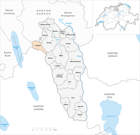
| Location of the municipality | |
  |
|
Bettwil (in local dialect : [ ˈb̥ɛpməl ]) is a municipality in the Swiss canton of Aargau . It belongs to the Muri district , is on the eastern edge of the Seetal and is the highest municipality in the canton.
geography
The village is located on a plateau on the western slope of the Lindenberg , around three kilometers east of Lake Hallwil . The plain is drained to the north by the Erusbach. Towards the east the terrain rises gently to the ridge of the Lindenberg, towards the northeast to the Niesenberg. The village of Bettwil is located in the far west of the municipality, half a kilometer south of it is the hamlet of Königsberg ( 692 m above sea level ). Brandholz ( 694 m above sea level ) is about two and a half kilometers south-east , and Guggibad ( 712 m above sea level ) another kilometer further on . The two last-mentioned hamlets on the eastern municipal border already belong geographically to the Bünztal .
The area of the municipality is 425 hectares , of which 93 hectares are forested and 43 hectares are built over. The highest point is at 760 m above sea level. M. in the Junkholz area, the deepest at 649 m above sea level. M. in the extreme northwest. Neighboring communities are Sarmenstorf in the north, Kallern in the northeast, Boswil in the east, Buttwil in the southeast, Schongau in the south Fahrwangen in the west.
history
The place is mentioned for the first time in 924 in an interest sled of the Fraumünsterstift in Zurich ( de Petiwilare / Pettewilare ). The place name is an Old High German combination of the personal name Beto / Petto and the trailing element -wīlāri, which is common in Alemannic foundations , to denote new court settlements. The most important landlord in the Middle Ages was Einsiedeln Monastery , which shared half of the tithe with the Bremgarten hospital . From 1200 to 1412 Bettwil was owned by the Lords of Heidegg, who resided at Heidegg Castle above Gelfingen . The Bettwiler then bought themselves free and submitted to the Habsburgs .

Their rule did not last long, however, because in 1415 the Confederates conquered Aargau. Bettwil became its own office within the Free Offices , a common rule . During the turmoil of the Reformation from 1529 to 1531, the Bettwiler remained true to the Catholic faith. In 1547 they were given their own village law as recognition. Without interference from the governor , they were allowed to choose the subordinate, the judges and all village officials themselves. The elections took place democratically every two years at electoral meetings. No other village in the immediate vicinity possessed this abundance of freedom.
In March 1798 the French took Switzerland and proclaimed the Helvetic Republic . Bettwil formed together with the Niesenberg (now part of Kallern ) a municipality in the Sarmenstorf district of the short-lived canton of Baden . In 1799 the Sarmenstorf parish separated. After the canton of Aargau was founded in 1803, Niesenberg was separated from Bettwil again. Bettwil remained dominated by agriculture well into the 20th century and the population stagnated at around 400. After the development of a new residential area in 1981, the population grew by around half. From the mid-1960s to the end of the 1990s, two batteries with Bloodhound anti-aircraft guided weapons were stationed near Bettwil .
Attractions

The parish church of St. Josef , which together with the parsonage and barn forms an intact assembly, was built in 1788/89 under the direction of the master builder Franz Joseph Rey. He built a simple hall church with a late baroque interior. The building material was supplied by the former chapel from 1496, which was rebuilt in 1729, but was demolished only 60 years later.
coat of arms
The blazon of the municipal coat of arms reads: "In white on a green three-mountain three green fir trees with red trunks." Five fir trees are depicted on a coat of arms from 1561, the coat of arms of the former office of Bettwil. On the municipal seal of 1811 three fir trees appeared, from 1872 on a blue background. In 1950 the shield color was changed to white and the flat floor was replaced by a three-mountain . However, this results in a certain similarity to the coat of arms of Olten .
population
The population developed as follows:
| year | 1850 | 1900 | 1930 | 1950 | 1960 | 1970 | 1980 | 1990 | 2000 | 2010 |
| Residents | 421 | 400 | 396 | 414 | 381 | 347 | 376 | 492 | 576 | 560 |
On December 31, 2019, 636 people lived in Bettwil, the proportion of foreigners was 10.2%. In the 2015 census, 55.2% described themselves as Roman Catholic and 18.0% as Reformed ; 26.8% were non-denominational or of other faiths. 97.6% said German as their main language in the 2000 census .
Politics and law
The assembly of those entitled to vote, the municipal assembly , exercises legislative power. The executing authority is the five-member municipal council . He is elected by the people in the majority procedure, his term of office is four years. The parish council leads and represents the parish. To this end, it implements the resolutions of the municipal assembly and the tasks assigned to it by the canton. The District Court of Muri is primarily responsible for legal disputes . Bettwil belongs to the peace judges circle XIII (Muri).
economy
According to the company structure statistics (STATENT) collected in 2015, Bettwil has around 230 jobs, of which 24% are in agriculture, 37% in industry and 39% in the service sector. Around two thirds of the workforce are commuters and work in the surrounding communities, especially in Wohlen and Villmergen .
traffic
Bettwil is away from through traffic, about two kilometers east of the important cantonal road 298 from Wohlen into the Seetal . A side street leads from Fahrwangen via Bettwil and the Lindenberg to Muri . Bettwil is the end of a bus route operated by Regionalbus Lenzburg , which runs from Lenzburg through the lower Seetal.
education

The community has a kindergarten and a primary school . The Realschule and the secondary school can be attended in Sarmenstorf or Meisterschwanden , the district school in Fahrwangen . The closest grammar school is the Cantonal School in Wohlen .
literature
- Anton Wohler: Bettwil. In: Historical Lexicon of Switzerland .
- Georg Germann : The art monuments of the canton Aargau . Ed .: Society for Swiss Art History . Volume V: The Muri District. Birkhäuser Verlag, Basel 1967, DNB 457321970 .
Web links
Individual evidence
- ↑ Cantonal population statistics 2019. Department of Finance and Resources, Statistics Aargau, March 30, 2020, accessed on April 2, 2019 .
- ↑ Cantonal population statistics 2019. Department of Finance and Resources, Statistics Aargau, March 30, 2020, accessed on April 2, 2019 .
- ↑ a b Beat Zehnder: The community names of the canton of Aargau . Historical sources and linguistic interpretations. In: Historical Society of the Canton of Aargau (Ed.): Argovia . Annual journal of the Historical Society of the Canton of Aargau. tape 100 / II . Verlag Sauerländer, Aarau 1991, ISBN 3-7941-3122-3 , p. 85 ff . The phonetic transcription given : bę́pməl .
- ↑ a b Andres Kristol: Bettwil AG (Muri) in: Dictionnaire toponymique des communes suisses - Lexicon of Swiss municipality names - Dizionario toponomastico dei comuni svizzeri (DTS | LSG). Center de dialectologie, Université de Neuchâtel, Verlag Huber, Frauenfeld / Stuttgart / Vienna 2005, ISBN 3-7193-1308-5 and Éditions Payot, Lausanne 2005, ISBN 2-601-03336-3 , p. 138f. Specified phonetic transcription : [ ˈbɛpməl ].
- ^ National map of Switzerland, sheet 1110, Swisstopo.
- ↑ Standard area statistics - municipalities according to 4 main areas. Federal Statistical Office , November 26, 2018, accessed on May 10, 2019 .
- ↑ Holed. Der Spiegel , December 12, 1962, accessed on January 13, 2014 .
- ^ Germann: The art monuments of the Canton of Aargau, Volume V: District of Muri. Pp. 76-82.
- ^ Joseph Galliker, Marcel Giger: Municipal coat of arms of the Canton of Aargau . Lehrmittelverlag des Kantons Aargau, book 2004, ISBN 3-906738-07-8 , p. 118 .
- ↑ Population development in the municipalities of the Canton of Aargau since 1850. (Excel) In: Eidg. Volkszählung 2000. Statistics Aargau, 2001, archived from the original on October 8, 2018 ; accessed on May 8, 2019 .
- ↑ Resident population by religious affiliation, 2015. (Excel) In: Population and Households, Community Tables 2015. Statistics Aargau, accessed on May 10, 2019 .
- ↑ Swiss Federal Census 2000: Economic resident population by main language as well as by districts and municipalities. (Excel) Statistics Aargau, archived from the original on August 10, 2018 ; accessed on May 8, 2019 .
- ↑ circles of justice of the peace. Canton of Aargau, accessed on June 20, 2019 .
- ↑ Statistics of the corporate structure (STATENT). (Excel, 157 kB) Statistics Aargau, 2016, accessed on May 8, 2019 .
Abtwil | Aristau | Auw | Beinwil (Freiamt) | Besenbüren | Bettwil | Boswil | Coins | Buttwil | Dietwil | Geltwil | Kallern | Merenschwand | Mühlau | Muri | Oberrüti | Rottenschwil | Sins | Waltenschwil
Former municipality: Benzenschwil | Forest houses | Will
Canton of Aargau | Districts of the Canton of Aargau | Municipalities in the Canton of Aargau