
Beinwil (Freiamt)
| Beinwil (Freiamt) | |
|---|---|
.svg) |
|
| State : |
|
| Canton : |
|
| District : | Muri |
| BFS no. : | 4224 |
| Postal code : | 5637 |
| Coordinates : | 668 702 / 231453 |
| Height : | 578 m above sea level M. |
| Height range : | 455–855 m above sea level M. |
| Area : | 11.31 km² |
| Residents: | 1175 (December 31, 2019) |
| Population density : | 104 inhabitants per km² |
|
Proportion of foreigners : (residents without citizenship ) |
8.9% (December 31, 2019) |
| Website: | www.beinwil.ch |
 Beinwil (Freiamt) |
|
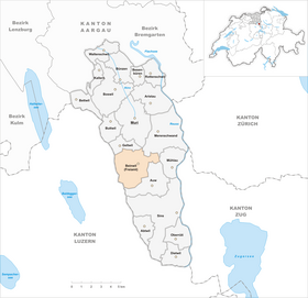
| Location of the municipality | |
 _2012.png) |
|
Beinwil (Freiamt) (in local dialect : Böiel, [ ˈb̥œi̯əl ]) is a municipality in the Swiss canton of Aargau . It belongs to the Muri district and is located in the upper Bünztal in the Freiamt region . Until the end of 1950 the community was called Beinwil bei Muri .
geography
The community consists of five small villages that are scattered on the eastern slope of the Lindenberg . The slope rises evenly and merges in the west into a plateau over 800 meters. It is divided by several, partly deeply cut ravines , the streams of which flow eastwards and flow into the Reuss . From north to south these are the Wissenbach, the Sembach and the Mariahaldenbach . Only the Rüeribach, one of the headwaters of the Bünz , flows north.
The main settlement of Beinwil ( 580 m above sea level ) is located roughly in the middle of the municipality on the Wissenbach. Wallenschwil ( 463 m above sea level ) is about one and a half kilometers east , and Wiggwil ( 592 m above sea level ) one kilometer south on the Sembach. One kilometer north of Beinwil is Winterschwil ( 575 m above sea level ) not far from the Rüeribach, one kilometer west of Brunnwil ( 719 m above sea level ). There are around a dozen individual farms scattered across the municipality, four of them on the Lindenberg plateau. At the Horben farm at 818 m above sea level. M. is the small castle Horben .
The area of the municipality is 1131 hectares , of which 206 hectares are forested and 86 hectares are built over. The highest point is at 854 m above sea level. M. in the Groderwald on the ridge of the Lindenberg, the deepest at 456 m above sea level. M. near Wallenschwil. Neighboring communities are Geltwil in the north, Merenschwand in the northeast, Mühlau in the east, Auw in the south and the Lucerne communities Hohenrain and Hitzkirch in the west.
history


Remnants of the wall and finds of small everyday objects west of Wallenschwil bear witness to settlement during the time of the Roman Empire , although the exact period is not known. Towards the end of the 7th century, the Alemanni settled here . The village was first mentioned in a document in 1153 as a designation of origin ( Harthmanno de Beinwilare ). The place name comes from an Old High German composition * Bāgin wīlāri or * Beininwīlāri and means "court settlement of the Bāgo or the Beino".
Shortly after it was founded in 1027, the Muri monastery owned land in the villages on Lindenberg. In 1239 a Hartmann Viselere ceded important properties and the associated rights to the monastery in Kappel am Albis . These came to the city of Zurich in 1415, to the Holdermeyer family in Lucerne in 1586 and finally to the Muri monastery in 1614. The monastery was able to gradually buy up the remaining land, which was held by various nobles. The state sovereignty lay with the Habsburgs , who also exercised high jurisdiction . The villages of Beinwil, Brunnwil, Wallenschwil and Wiggwil were part of the Meienberg office , Winterschwil was part of the Muri office.
There is historical evidence that a Gessler family lived in neighboring Wiggwil until at least 1412 . The Gesslers were subordinates of the village and ministerials of the Habsburgs. A Hermann Gessler should according to legend Bailiff of Uri and Schwyz have been, and in 1307 of William Tell have been shot. In fact there was a bailiff Gessler, but only in 1375 in Grüningen in the canton of Zurich . After the publication of the White Book of Sarnen in 1470 at the latest , Gessler was the epitome of tyranny, and the family name was therefore changed. Even today there are people with the surname Gisler .
In 1415 Lucerne conquered the Habsburg office of Meienberg, but in 1425 had to return it to the common property of the Confederates . The free offices (later: Freiamt), a common rule, were formed from the conquered areas . In March 1798 the French took Switzerland and proclaimed the Helvetic Republic . Beinwil, Brunnwil and Wiggwil were combined into one municipality and belonged to the Muri district in the short-lived canton of Baden . Winterschwil formed its own municipality with Geltwil and was united with Beinwil after the canton of Aargau was founded in 1803. Wallenschwil formed an agency with Rüstenschwil in Helveticia and this with Auw a municipality. When the villages were merged to form the municipality of Beinwil, local citizens' communities were created for Beinwil, Brunnwil, Wallenschwil, Wiggwil and Winterschwil.
Until well into the 20th century, the majority of the population of the municipality of Beinwil lived from agriculture. The first schoolhouse was built in 1812, electricity arrived in 1909 (in Brunnwil not until 1915). The population, which had decreased by almost twenty percent in the second half of the 19th century, remained relatively constant until around 1980. Since then there has been a slight increase again.
Attractions

-Preghejeto_312.jpg)

The parish church of St. Burkard is a well-known place of pilgrimage , as the remains of Burkard von Beinwil , who died in 1192 and canonized in 1817 , are laid out here. The church building was first mentioned in a document in 1239. After the Muri monastery took over the patronage rights in 1614, Abbot Johann Jodok Singisen commissioned a new building in 1618. Due to poor execution, the church tower had to be demolished and rebuilt in 1645. In 1797 the nave was completely rebuilt and extended.
The hamlet of Winterschwil received the Aargau Heritage Protection Prize in 1987 for its intact appearance. The St. Laurentius Chapel , built in 1745, is located in Wallenschwil . Also worth seeing is the Eichmühle on the outskirts of Wiggwil, which has existed since at least 1584 and is still in operation today. The Castle Horben high on the Lindenberg was 1700/1701 as a convalescent home for the monks of the monastery Muri built; The St. Wendelin Palace Chapel with its baroque wall paintings is open to the public, unlike the Palace.
coat of arms
The blazon of the municipal coat of arms reads: "Green linden tree with five leaves torn in yellow." The community seal already contained a linden tree, alluding to the Lindenberg . The current stylized form was introduced in 1951. The coat of arms of Auw has the same motif, but on a white background.
population
The population developed as follows:
| year | 1850 | 1900 | 1930 | 1950 | 1960 | 1970 | 1980 | 1990 | 2000 | 2010 |
| Residents | 871 | 701 | 744 | 759 | 803 | 752 | 695 | 817 | 942 | 1,036 |
On December 31, 2019, 1175 people lived in Beinwil, the proportion of foreigners was 8.9%. In the 2015 census, 66.2% described themselves as Roman Catholic and 10.8% as Reformed ; 23.0% were non-denominational or of other faiths. 98.4% said German as their main language in the 2000 census .
Politics and law
The assembly of those entitled to vote, the municipal assembly , exercises legislative power. The executing authority is the five-member municipal council . He is elected by the people in the majority procedure, his term of office is four years. The parish council leads and represents the parish. To this end, it implements the resolutions of the municipal assembly and the tasks assigned to it by the canton. The District Court of Muri is primarily responsible for legal disputes . Beinwil belongs to the Friedensrichterkreis XIII (Muri).
economy
According to the company structure statistics (STATENT) collected in 2015, Beinwil has around 450 jobs, of which 27% in agriculture, 25% in industry and 48% in the service sector. Most of the workers are commuters and work in Muri or in the agglomerations of the cities of Lucerne and Zug .
The Horben high plateau with the castle of the same name is a popular destination, especially on weekends. An extensive network of hiking trails is available in summer . In winter, when there is enough snow, a short ski lift is put into operation and three cross- country trails are groomed. The Lindenberg trail is 12 kilometers long, the Horben trail 4.4 kilometers. Another 4.2 kilometer long trail is illuminated at night.
traffic
The individual villages are located away from through traffic; The only exception is the village of Wallenschwil directly on the busy Hauptstrasse 25 ( Lenzburg - Zug ). The main town and the other villages are connected to Muri and Auw by a well-developed network of secondary roads . A post bus line runs from Muri via Wallenschwil and Beinwil up to Brunnwil, while Winterschwil and Wiggwil are not connected to public transport. On weekends there is a night bus from Zug via Sins and Muri to Mühlau , which only serves Wallenschwil.
education
The community has a kindergarten and a primary school in the main town of Beinwil. All upper levels of the compulsory elementary school ( junior high school , secondary school , district school ) can be attended in Muri . The closest grammar school is the Cantonal School in Wohlen .
Personalities
- Vincenz Küng (1764–1843), councilor and judge
- Al'Leu (1953–2018), artist and publisher
- Emil Nietlispach (1887–1962), National Councilor and federal judge
- Jakob Nietlispach (1848–1918), National Councilor and bank founder
- Markus Zemp (* 1954), National Councilor
literature
- Anton Wohler: Beinwil (Freiamt). In: Historical Lexicon of Switzerland .
- Georg Germann : The art monuments of the canton Aargau . Ed .: Society for Swiss Art History . Volume V: The Muri District. Birkhäuser Verlag, Basel 1967, DNB 457321970 .
Web links
Individual evidence
- ↑ Cantonal population statistics 2019. Department of Finance and Resources, Statistics Aargau, March 30, 2020, accessed on April 2, 2019 .
- ↑ Cantonal population statistics 2019. Department of Finance and Resources, Statistics Aargau, March 30, 2020, accessed on April 2, 2019 .
- ↑ a b Beat Zehnder: The community names of the canton of Aargau . Historical sources and linguistic interpretations. In: Historical Society of the Canton of Aargau (Ed.): Argovia . Annual journal of the Historical Society of the Canton of Aargau. tape 100 / II . Verlag Sauerländer, Aarau 1991, ISBN 3-7941-3122-3 , p. 75 f . The phonetic transcription given : bǫ̈́i̯əl .
- ↑ a b Gabrielle Schmid: Beinwil (Freiamt) AG (Muri) in: Dictionnaire toponymique des communes suisses - Lexicon of Swiss community names - Dizionario toponomastico dei comuni svizzeri (DTS | LSG). Center de dialectologie, Université de Neuchâtel, Verlag Huber, Frauenfeld / Stuttgart / Vienna 2005, ISBN 3-7193-1308-5 and Éditions Payot, Lausanne 2005, ISBN 2-601-03336-3 , p. 131. The phonetic transcription used : [ ˈbœjəl ].
- ↑ a b National map of Switzerland, sheet 1110, Swisstopo.
- ↑ Standard area statistics - municipalities according to 4 main areas. Federal Statistical Office , November 26, 2018, accessed on May 10, 2019 .
- ^ Martin Hartmann, Hans Weber: The Romans in Aargau . Verlag Sauerländer, Aarau 1985, ISBN 3-7941-2539-8 , p. 164 .
- ↑ Erhard Huwyler-Frei: The civil sexes. Beinwil community (Freiamt), September 2006, archived from the original on October 1, 2018 ; Retrieved January 9, 2010 .
- ^ A b Germann: The art monuments of the Canton of Aargau, Volume V: District of Muri.
- ^ Joseph Galliker, Marcel Giger: Municipal coat of arms of the Canton of Aargau . Lehrmittelverlag des Kantons Aargau, book 2004, ISBN 3-906738-07-8 , p. 111 .
- ↑ Population development in the municipalities of the Canton of Aargau since 1850. (Excel) In: Eidg. Volkszählung 2000. Statistics Aargau, 2001, archived from the original on October 8, 2018 ; accessed on May 8, 2019 .
- ↑ Resident population by religious affiliation, 2015. (Excel) In: Population and Households, Community Tables 2015. Statistics Aargau, accessed on May 10, 2019 .
- ↑ Swiss Federal Census 2000: Economic resident population by main language as well as by districts and municipalities. (Excel) Statistics Aargau, archived from the original on August 10, 2018 ; accessed on May 8, 2019 .
- ↑ circles of justice of the peace. Canton of Aargau, accessed on June 20, 2019 .
- ↑ Statistics of the corporate structure (STATENT). (Excel, 157 kB) Statistics Aargau, 2016, accessed on May 8, 2019 .
- ↑ No chance for winter grouches. (PDF) Aargauer Zeitung , January 2007, accessed on January 9, 2010 .
Abtwil | Aristau | Auw | Beinwil (Freiamt) | Besenbüren | Bettwil | Boswil | Coins | Buttwil | Dietwil | Geltwil | Kallern | Merenschwand | Mühlau | Muri | Oberrüti | Rottenschwil | Sins | Waltenschwil
Former municipality: Benzenschwil | Forest houses | Will
Canton of Aargau | Districts of the Canton of Aargau | Municipalities in the Canton of Aargau