
Besenbüren
| Besenbüren | |
|---|---|
 |
|
| State : |
|
| Canton : |
|
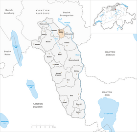
| District : | Muri |
| BFS no. : | 4226 |
| Postal code : | 5627 |
| Coordinates : | 668 463 / 240514 |
| Height : | 450 m above sea level M. |
| Height range : | 417–497 m above sea level M. |
| Area : | 2.38 km² |
| Residents: | 626 (December 31, 2019) |
| Population density : | 263 inhabitants per km² |
|
Proportion of foreigners : (residents without citizenship ) |
7.7% (December 31, 2019) |
| Website: | www.besenbueren.ch |
 |
|
| Location of the municipality | |
  |
|
Besenbüren (in local dialect : [ ˈb̥æsiˌb̥ʏːɾə ]) is a municipality in the Swiss canton of Aargau . It belongs to the Muri district and is located in the central Bünztal .
geography
The community is located on the edge of the Bünz plane on the foothills of the Wagenrain , around one and a half kilometers east of the Bünz and two and a half kilometers west of the Reuss . Most of the municipal area is largely flat, only in the north-west and north-east is the terrain hilly.
The area of the municipality is 238 hectares , of which 48 hectares are forested and 28 hectares are built over. The highest point is at 498 m above sea level. M. on the north-western edge of the village, the deepest at 436 m above sea level. M. on the southern border of the municipality. Neighboring communities are Bremgarten in the north, Rottenschwil in the east, Aristau in the south-east, Boswil in the south-west and Bünzen in the north-west.
history
In forums moss on the southern municipal boundary were discovered various items from the Old and Middle Stone Age , including stone axes and hand axes . Various lance tips that were found at the same location date from the Bronze Age .
The place Besenbüren is attested several times in documents from the 14th century (1303–1308 ze Bessembuͥrron , Bessenbuͥron ; after 1312 from Besembúren , ze Besembúrren ; 1361 ze Besenbüren ), and also the Acta Murensia , which dates back to around 1160, mention it: in Besenbürren mansum . The place name is an Old High German combination of the personal name Baso and the defining word būria / būrrea / būrra «dwelling, dwelling», which indicates an Alemannic foundation in the 6th to 8th centuries. Landlords in the Middle Ages were the monasteries of Muri and Engelberg . Besenbüren was in the Habsburg office of Muri. While the Habsburgs the high jurisdiction exercised, which was lower jurisdiction at the lords of Heidegg that in Heidegg Castle above Gelfingen resided.

In 1415 the Swiss conquered Aargau, and Besenbüren was now part of the Boswil office in the Free Offices , a common rule . The Lords of Heidegg retained their rights among the Confederates. In 1471 they sold them to the Muri monastery and bought them back a few years later, only to finally sell them to the monastery in 1617. In March 1798 the French took Switzerland and proclaimed the Helvetic Republic . Besenbüren was initially a municipality in the short-lived canton of Baden , since 1803 it has belonged to the canton of Aargau.
During the second half of the 19th century, the population decreased by over 30 percent. Numerous house fires, poverty and shortage of land forced people to emigrate. The community remained agricultural until well into the 20th century . Around 1980 the low was reached with 280 inhabitants; however, construction then began and the village grew to double its population within 25 years.
Attractions
coat of arms
The blazon of the municipal coat of arms reads: "In yellow on a green hill, green leafy birch with a white trunk, surrounded by two red cranberry blossoms with black clusters and green leafy stems." Birches and cranberries are part of the typical flora of Besenbüren. The motif first appeared on the municipal seal in 1811, the shape was definitely determined in 1961. However, the coat of arms is heraldically incorrect: the hill is jagged instead of round, and the number of leaves on the stem of the cranberry blossom is not symmetrical (four would be correct instead of five). In 2002, the municipal council rejected the State Archives' proposal to slightly change the coat of arms.
population
The population developed as follows:
| year | 1850 | 1900 | 1930 | 1950 | 1960 | 1970 | 1980 | 1990 | 2000 | 2010 |
| Residents | 417 | 289 | 327 | 322 | 320 | 302 | 280 | 387 | 496 | 592 |
On December 31, 2019, 626 people lived in Besenbüren, the proportion of foreigners was 7.7%. In the 2015 census, 50.1% described themselves as Roman Catholic and 18.6% as Reformed ; 31.3% were non-denominational or of other faiths. 97.2% said German as their main language in the 2000 census .
Politics and law
The assembly of those entitled to vote, the municipal assembly , exercises legislative power. The executing authority is the five-member municipal council . He is elected by the people in the majority procedure, his term of office is four years. The parish council leads and represents the parish. To this end, it implements the resolutions of the municipal assembly and the tasks assigned to it by the canton. The District Court of Muri is primarily responsible for legal disputes . Besenbüren belongs to the Friedensrichterkreis XIII (Muri).
economy
According to the corporate structure statistics (STATENT) collected in 2015, Besenbüren has around 120 jobs, of which 27% are in agriculture, 27% in industry and 46% in the service sector. The majority of those in work are commuters and work in the surrounding communities in the Bünztal (especially Wohlen and Muri ), and in some cases also in the Zurich agglomeration .
traffic

The community is away from through traffic, but is only about half a kilometer west of Kantonsstrasse 296 between Bremgarten and Sins . About three kilometers to the west, near Boswil , the main road 25 runs between Lenzburg and Sins. A post bus line leads from Wohlen station via Besenbüren to Muri .
education
The community has a kindergarten . The primary school is run as the Bünz district school, with two school locations in Bünzen and Besenbüren. The Realschule and the secondary school can be attended in Boswil , the district school in Muri . The closest grammar school is the Cantonal School in Wohlen .
Personalities
- Hermann Huber (1863–1915), member of the government
literature
- Anton Wohler: Besenbüren. In: Historical Lexicon of Switzerland .
- Georg Germann : The art monuments of the canton Aargau . Ed .: Society for Swiss Art History . Volume V: The Muri District. Birkhäuser Verlag, Basel 1967, DNB 457321970 .
Web links
Individual evidence
- ↑ Cantonal population statistics 2019. Department of Finance and Resources, Statistics Aargau, March 30, 2020, accessed on April 2, 2019 .
- ↑ Cantonal population statistics 2019. Department of Finance and Resources, Statistics Aargau, March 30, 2020, accessed on April 2, 2019 .
- ↑ a b Beat Zehnder: The community names of the canton of Aargau . Historical sources and linguistic interpretations. In: Historical Society of the Canton of Aargau (Ed.): Argovia . Annual journal of the Historical Society of the Canton of Aargau. tape 100 / II . Verlag Sauerländer, Aarau 1991, ISBN 3-7941-3122-3 , p. 84 f . The phonetic transcription used : bé͈sibǖ̀rə .
- ↑ a b Gabrielle Schmid: Besenbüren AG (Muri) in: Dictionnaire toponymique des communes suisses - Lexicon of Swiss municipality names - Dizionario toponomastico dei comuni svizzeri (DTS | LSG). Center de dialectologie, Université de Neuchâtel, Verlag Huber, Frauenfeld / Stuttgart / Vienna 2005, ISBN 3-7193-1308-5 and Éditions Payot, Lausanne 2005, ISBN 2-601-03336-3 , p. 145. Quoted phonetic transcription : [ ˈbɛrkχə ].
- ^ National map of Switzerland, sheet 1110, Swisstopo.
- ↑ Standard area statistics - municipalities according to 4 main areas. Federal Statistical Office , November 26, 2018, accessed on May 10, 2019 .
- ^ Joseph Galliker, Marcel Giger: Municipal coat of arms of the Canton of Aargau . Lehrmittelverlag des Kantons Aargau, book 2004, ISBN 3-906738-07-8 , p. 117 .
- ↑ Population development in the municipalities of the Canton of Aargau since 1850. (Excel) In: Eidg. Volkszählung 2000. Statistics Aargau, 2001, archived from the original on October 8, 2018 ; accessed on May 8, 2019 .
- ↑ Resident population by religious affiliation, 2015. (Excel) In: Population and Households, Community Tables 2015. Statistics Aargau, accessed on May 10, 2019 .
- ↑ Swiss Federal Census 2000: Economic resident population by main language as well as by districts and municipalities. (Excel) Statistics Aargau, archived from the original on August 10, 2018 ; accessed on May 8, 2019 .
- ↑ circles of justice of the peace. Canton of Aargau, accessed on June 20, 2019 .
- ↑ Statistics of the corporate structure (STATENT). (Excel, 157 kB) Statistics Aargau, 2016, accessed on May 8, 2019 .
Abtwil | Aristau | Auw | Beinwil (Freiamt) | Besenbüren | Bettwil | Boswil | Coins | Buttwil | Dietwil | Geltwil | Kallern | Merenschwand | Mühlau | Muri | Oberrüti | Rottenschwil | Sins | Waltenschwil
Former municipality: Benzenschwil | Forest houses | Will
Canton of Aargau | Districts of the Canton of Aargau | Municipalities in the Canton of Aargau