Batalha
| Batalha | ||||||
|---|---|---|---|---|---|---|
|
||||||
| Basic data | ||||||
| Region : | Centro | |||||
| Sub-region : | Region of Leiria | |||||
| District : | Leiria | |||||
| Concelho : | Batalha | |||||
| Coordinates : | 39 ° 39 ′ N , 8 ° 49 ′ W | |||||
| Residents: | 8548 (as of June 30, 2011) | |||||
| Surface: | 28.42 km² (as of January 1, 2010) | |||||
| Population density : | 301 inhabitants per km² | |||||
| Postal code : | 2240-118 | |||||
| politics | ||||||
| Mayor : | Germano Santos Pragosa | |||||
| Address of the municipal administration: | Junta de Freguesia de Batalha Rua Infante D. Fernando, nº 432 2240-118 Batalha |
|||||
| Website: | www.jf-batalha.pt | |||||
| Batalha district | ||||||
|
||||||
| Residents: | 15,805 (as of June 30, 2011) | |||||
| Surface: | 103.42 km² (as of January 1, 2010) | |||||
| Population density : | 153 inhabitants per km² | |||||
| Number of municipalities : | 4th | |||||
| administration | ||||||
| Administration address: | Câmara Municipal de Batalha Rua Infante D. Fernando 2440-118 Batalha |
|||||
| President of the Câmara Municipal: | Paulo Jorge Frazão Batista dos Santos ( PSD ) | |||||
| Website: | www.cm-batalha.pt | |||||
Batalha ( port. Battle ) is a Portuguese town ( Vila ). It has 8,548 inhabitants (as of June 30, 2011) and is located about 120 kilometers north of Lisbon .
It is known for the eponymous monastery Batalha , the Mosteiro de Santa Maria da Vitória . It was built from the 14th to the 16th centuries and was added to the UNESCO World Heritage List in 1983. The Grutas da Moeda caves are also in the district.
coat of arms
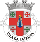
In silver a continuous red cross with the Mother of God and the child. It is angled by four lily end crosses, which are diagonally in green and red. A four-tower wall crown rests on the shield . In the white band at the base of the shield, the place name in black letters "VILA DA BATALHA".
geography
Batalha is about 10 km south of the district capital Leiria , about 20 km west of the pilgrimage site Fátima , and about 120 km north of the capital Lisbon . Much of the district is covered by forests, especially spruce and cork oak .
history
Finds in the circle prove a settlement back to the Paleolithic . The Roman town of Collipo, a city in the province of Lusitania , later existed near São Sebastião de Freixo .
After the revolution of 1383 there was a war for the Portuguese throne. On the afternoon of August 14, 1385 , the Portuguese troops emerged victorious from the battle of Aljubarrota against the outnumbered Castilian army, thus ensuring the independence of the Kingdom of Portugal . As a thank you for the presumed heavenly assistance, King D. João I promised to build a mighty monastery, the unfinished Batalha Monastery, built over several centuries . In connection with its construction, the king founded the city of Batalha ( Portuguese for battle) , starting from a small town already located here .
- The legend of the Aljubarrota baker's wife

In connection with the Battle of Aljubarrota, the legend of the Padeira de Aljubarrota , which is still popular today, arose : the baker of Aljubarrota. According to her, the baker's wife Brites de Almeida was in town at the time of the battle, while seven Spaniards fled the battlefield and hid in the baker's empty house. On her return, she found the front door locked, suspected, and searched her home for intruders. She finally found the seven Castilians in her oven, and shooed them out one by one to kill them one by one with her oven slide. Although historians pointed to a legend without historical evidence from the start, the episode, interpreted in a humorous and patriotic way, has survived to this day.
administration
Batalha district
Batalha is the administrative seat of a district of the same name ( concelho ) in the Leiria district . On June 30, 2011, the district had 15,805 inhabitants on an area of 103.4 km².
The neighboring areas are (starting clockwise in the north): Leiria , Vila Nova de Ourém , Alcanena and Porto de Mós .
The following municipalities ( Freguesias ) are in the Batalha district:
| local community | Population (2011) |
Area km² |
Density of population / km² |
LAU code |
|---|---|---|---|---|
| Batalha | 8,548 | 28.42 | 301 | 100401 |
| Golpilheira | 1,528 | 5.06 | 302 | 100404 |
| Reguengo do Fetal | 2,169 | 28.17 | 77 | 100402 |
| São Mamede | 3,560 | 41.77 | 85 | 100403 |
| Batalha district | 15,805 | 103.42 | 153 | 1004 |
Population development
| Population in Batalha County (1801–2011) | |||||||||
|---|---|---|---|---|---|---|---|---|---|
| 1801 | 1849 | 1900 | 1930 | 1960 | 1981 | 1991 | 2001 | 2004 | 2011 |
| 2,510 | 2,445 | 7.107 | 9,634 | 13,811 | 12,588 | 13,329 | 15.002 | 15,542 | 15,837 |
Municipal holiday
- August 14th
Town twinning
-
 Trujillo in Extremadura (Spain), since 1992
 -
 Joinville-le-Pont in Île-de-France (France), since 2007
sons and daughters of the town
- Joaquim Augusto Mouzinho de Albuquerque (1855–1902), military and colonial administrator, defeated King Gungunhana in what is now Mozambique
- Moisés Espírito Santo (* 1934), sociologist, ethnologist and university professor
- Rui Manuel Gens de Moura Ramos (* 1950), lawyer, university professor, judge at international courts of law, 2007–2012 President of the Portuguese Constitutional Court ( Tribunal Constitucional )
- Virgílio do Nascimento Antunes (* 1961), Bishop of Coimbra
- Suzana (* 1976), singer
Web links
- Map of the Freguesia Batalha at the Instituto Geográfico do Exército
- Official website of the city administration
Individual evidence
- ↑ www.ine.pt - indicator resident population by place of residence and sex; Decennial in the database of the Instituto Nacional de Estatística
- ↑ a b Overview of code assignments from Freguesias on epp.eurostat.ec.europa.eu
- ↑ a b www.ine.pt - indicator resident population by place of residence and sex; Decennial in the database of the Instituto Nacional de Estatística
- ↑ www.verportugal.net , accessed on November 6, 2013
- ^ Page of town twinning on the website of the town administration, accessed on November 9, 2013
| ← Previous location: Caldas da Rainha |
|
Next town: Coimbra → |


