Leiria
| Leiria | ||||||
|---|---|---|---|---|---|---|
|
||||||
| Basic data | ||||||
| Region : | Centro | |||||
| Sub-region : | Region of Leiria | |||||
| District : | Leiria | |||||
| Concelho : | Leiria | |||||
| Coordinates : | 39 ° 45 ′ N , 8 ° 48 ′ W | |||||
| Residents: | 14,939 (as of June 30, 2011) | |||||
| Surface: | 6.47 km² (as of January 1, 2010) | |||||
| Population density : | 2309 inhabitants per km² | |||||
| Postal code : | 2400- / 2410- | |||||
| Leiria district | ||||||
|
||||||
| Residents: | 126,884 (as of June 30, 2011) | |||||
| Surface: | 565.08 km² (as of January 1, 2010) | |||||
| Population density : | 225 inhabitants per km² | |||||
| Number of municipalities : | 18th | |||||
| administration | ||||||
| Administration address: | Câmara Municipal de Leiria Largo da Républica, 1 2414-006 Leiria |
|||||
| President of the Câmara Municipal: | Raul Miguel de Castro ( PS ) | |||||
| Website: | www.cm-leiria.pt | |||||
Leiria ( IPA [ lɐi'ɾiɐ ]) is a city in central Portugal and the capital of the Leiria District . It has 14,939 inhabitants (as of June 30, 2011) and is primarily of tourist importance as a starting point for excursions to Fátima , Alcobaça and Batalha .
Geographical location
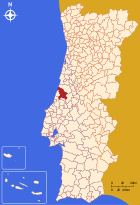
Leiria is located between Lisbon (140 km) and Porto (179 km), about 55 km southwest of Coimbra . The Lis River flows through the city from south to northwest. The Lena River flows into the Lis in the west of the city .
history
Leiria emerged from the Roman city of Collipo , which in turn was founded in the 1st century BC. . BC was founded. In 1135, the first Portuguese king, Alfonso I , conquered the city from the Moors during the Reconquista . He and his successor Sancho I fortified the city and built Leiria Castle . The sixth king of Portugal Dionysius had a royal residence built in Leiria in the 14th century. He gave the city as a fief to his wife Elisabeth of Portugal . John I had a royal palace and a Gothic church Igreja de Nossa Senhora da Pena built within the castle walls in the late 15th century . The city charter was Leiria in 1545 and seating was at the same time the diocese. Leiria Cathedral was built in the late 16th century .
traffic
Leiria is connected to the motorway network via the A8 motorway. The city is crossed by the national road N1 that connects Lisbon with Porto . The A1 runs to the east , which also connects Lisbon and Porto. The Linha do Oeste railway connects Leiria with Figueira da Foz , Coimbra and Lisbon.
Public facilities
The former city palace now serves as the Pousada de Juventude de Leiria youth hostel .
- Attractions
Sports
União Leiria football club played in the first division for many years until they were relegated in 2012. His home stadium is the Estádio Dr. Magalhães Pessoa , which opened for the 2004 European Football Championship . Since then, concerts and other sporting events have taken place there alongside national and international football matches, such as the 2009 European Athletics Team Championship .
administration
Leiria district
Leiria is the capital of the district of the same name and a district of the same name. The neighboring districts are (starting in the north clockwise) Pombal , Vila Nova de Ourém , Batalha , Porto de Mós , Alcobaça and Marinha Grande .
With the regional reform in September 2013, several municipalities were merged into new municipalities, so that the number of municipalities decreased from 29 to 18.
The following parishes are part of Leiria County:
| local community | Population (2011) |
Area km² |
Density of population / km² |
LAU code |
|---|---|---|---|---|
| Cupid | 4,747 | 23.48 | 202 | 100901 |
| Arrabal | 2,684 | 20.09 | 134 | 100902 |
| Bajouca | 2,004 | 12.27 | 163 | 100925 |
| Bidoeira de Cima | 2,250 | 15.61 | 144 | 100926 |
| Caranguejeira | 4,691 | 30.99 | 151 | 100907 |
| Coimbrão | 1,735 | 52.19 | 33 | 100909 |
| Colmeias e Memória | 4,085 | 46.57 | 88 | 100932 |
| Leiria, Pousos, Barreira e Cortes | 31,775 | 52.26 | 608 | 100933 |
| Maceira | 9,901 | 47.03 | 211 | 100913 |
| Marrazes e Barosa | 24,684 | 32.80 | 753 | 100934 |
| Milagres | 3,071 | 17.35 | 177 | 100915 |
| Monte Real e Carvide | 5,756 | 26.03 | 221 | 100935 |
| Monte Redondo e Carreira | 5,564 | 50.91 | 109 | 100936 |
| Parceiros e Azoia | 6,940 | 22.99 | 302 | 100937 |
| Regueira de Pontes | 2,221 | 11.55 | 192 | 100921 |
| Santa Catarina da Serra e Chainça | 4,870 | 41.20 | 118 | 100938 |
| Santa Eufémia e Boa Vista | 4,072 | 19.55 | 208 | 100939 |
| Souto de Carpalhosa e Ortigosa | 5,834 | 42.21 | 138 | 100940 |
| Leiria district | 126,884 | 565.08 | 225 | 1009 |
Population development
| Population in Leiria County (1801–2011) | ||||||||||
|---|---|---|---|---|---|---|---|---|---|---|
| 1801 | 1849 | 1900 | 1930 | 1960 | 1981 | 1991 | 2001 | 2011 | ||
| 37,930 | 29,803 | 54,422 | 55.234 | 82,988 | 96,517 | 102,762 | 119,847 | 126,879 | ||
Town twinning
-
 Japan : Tokushima (since 1969)
 -
 Portugal : Setúbal (since 1982)
 -
 France : Saint-Maur-des-Fossés (since 1982)
 -
 Brazil : Maringá (since 1982)
 -
 Spain : Olivenza (since 1984)
 -
 Cape Verde : São Filipe (since 1994)
 -
 Germany : Rheine (since 1996)
 -
 United Kingdom : Halton (since 1997)
 -
 People's Republic of China : Tongling (since 1999, cooperation agreement)
 -
 Mozambique : Nampula (since 2002, cooperation agreement)
sons and daughters of the town
|
|
Web links
- Map of the Freguesia Leiria at the Instituto Geográfico do Exército
- Official tourist guide of the region (multilingual)
Individual evidence
- ↑ www.ine.pt - indicator resident population by place of residence and sex; Decennial in the database of the Instituto Nacional de Estatística
- ↑ a b Overview of code assignments from Freguesias on epp.eurostat.ec.europa.eu
- ↑ Archived copy ( memento of the original from August 8, 2010 in the Internet Archive ) Info: The archive link was inserted automatically and has not yet been checked. Please check the original and archive link according to the instructions and then remove this notice.
- ↑ www.ine.pt - indicator resident population by place of residence and sex; Decennial in the database of the Instituto Nacional de Estatística
- ^ Publication of the administrative reorganization in the Diário da República gazette of January 28, 2013, accessed on March 16, 2014
- ↑ www.anmp.pt , accessed December 26, 2012
| ← Previous location: Tomar |
|
Next town: Alvaiázere → |


