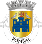
Pombal (Portugal)
| Pombal | ||||||
|---|---|---|---|---|---|---|
|
||||||
| Basic data | ||||||
| Region : | Centro | |||||
| Sub-region : | Region of Leiria | |||||
| District : | Leiria | |||||
| Concelho : | Pombal | |||||
| Coordinates : | 39 ° 55 ′ N , 8 ° 38 ′ W | |||||
| Residents: | 17,225 (as of June 30, 2011) | |||||
| Surface: | 93.98 km² (as of January 1, 2010) | |||||
| Population density : | 183 inhabitants per km² | |||||
| Postal code : | 3100 | |||||
| politics | ||||||
| Mayor : | António Nascimento Lopes | |||||
| Address of the municipal administration: | Junta de Freguesia de Pombal Praça Faria da Gama 3100 Pombal |
|||||
| Website: | www.freguesia-pombal.pt | |||||
| Pombal district | ||||||
|
||||||
| Residents: | 55,245 (as of June 30, 2011) | |||||
| Surface: | 626 km² (as of January 1, 2010) | |||||
| Population density : | 88 inhabitants per km² | |||||
| Number of municipalities : | 13 | |||||
| administration | ||||||
| Administration address: | Câmara Municipal de Pombal Largo do Cardal 3100-440 Pombal |
|||||
| President of the Câmara Municipal: | Dr. Luís Diogo de Paiva Morão de Alves Mateus ( PSD ) | |||||
| Website: | www.cm-pombal.pt | |||||
Pombal is a city in Portugal with 17,225 inhabitants (as of June 30, 2011).
history
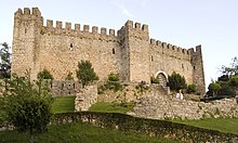
Traces point to a settlement since the Neolithic Age . Later there was a Roman village in the province of Lusitania , as found u. a. occupied by coins. In addition, the Romans built a fortress here, which was rebuilt by the Moors from 711 after the Arab conquest .
In the course of the Reconquista , D.Afonso Henriques conquered the area and gave it to the Knights Templar . In 1126 they found a small settlement at Chões , which has now disappeared, and they rebuilt the Arab fortress in 1128 . Today's Pombal was repopulated and is therefore considered to have been founded by the Knight Templar Gualdim Pais . The place received its first city rights in 1174 . In 1509 King D. Manuel I had the fortress renewed and in 1512 he gave the place renewed city rights.
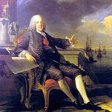
After his dismissal in 1777 , the absolutist Prime Minister Marquês de Pombal (Eng .: the Margrave of Pombal) settled on his local estates and reorganized the lower town. The prison building was erected on the old square (Praça Velha) on which the old stake stood, and opposite the town's granaries. Further buildings and reorganizations followed at the end of the 18th century, including a direct connection of the town center to the royal overland road. In the course of the Napoleonic invasions in the early 19th century, Pombal then suffered looting and severe destruction by the French invading army, as a result of which the place experienced a severe decline and remained almost deserted.
In the second half of the 20th century, Pombal regained the attention of administration and economy, especially thanks to its central location. Since then, the city has experienced steady growth. Signs of the reawakened city are the numerous city festivals, as well as the Teatro Amador , which opened in 1976 and which has already toured nationwide with various pieces.
The previous small town ( Vila ) Pombal was elevated to a city ( Cidade ) in 1991 .
Sports
The football club Sporting Clube de Pombal emerged in 1922 from the merger of the two local football clubs Glória Football-Club and Operário , and became the tenth subsidiary of the Sporting Clube de Portugal . He plays his home games in the 3,000-seat municipal stadium ( Estádio Municipal de Pombal ). The club played several times in the third division, the then IIª Divisão (today Campeonato Nacional de Seniores ), and has been in the divisions of the district association since 2013 (status: 2013/14 season) . In addition to soccer, the club also does other sports, including swimming, karate and gymnastics.
administration
The Pombal district
Pombal is the seat of a district of the same name ( concelho ) in the Leiria district . On June 30, 2011 the district had 55,245 inhabitants on an area of 626 km².
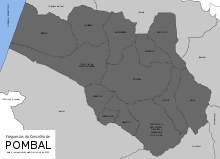
The neighboring areas are (starting clockwise in the north): Figueira da Foz , Soure , Ansião , Alvaiázere , Vila Nova de Ourém , Leiria and the Atlantic Ocean .
With the regional reform in September 2013 , several municipalities were merged into new municipalities, so that the number of municipalities decreased from 17 to 13.
The following municipalities ( Freguesias ) are in the Pombal district:
| local community | Population (2011) |
Area km² |
Density of population / km² |
LAU code |
|---|---|---|---|---|
| Abiul | 2,765 | 54.14 | 51 | 101501 |
| Almagreira | 3,076 | 42.61 | 72 | 101503 |
| Carnide | 1,738 | 22.31 | 78 | 101504 |
| Carriço | 3,620 | 83.05 | 44 | 101505 |
| Guia, Ilha e Mata Mourisca | 6,489 | 80.37 | 81 | 101518 |
| Louriçal | 4,645 | 47.66 | 97 | 101506 |
| Meirinhas | 1,742 | 8.89 | 196 | 101515 |
| Pelariga | 2,186 | 26.35 | 83 | 101508 |
| Pombal | 17,225 | 93.98 | 183 | 101509 |
| Redinha | 2.117 | 41.39 | 51 | 101510 |
| Santiago e São Simão de Litém e Albergaria dos Doze | 5,418 | 70.88 | 76 | 101519 |
| Vermoil | 2,617 | 22.80 | 115 | 101513 |
| Vila Cã | 1,607 | 31.57 | 51 | 101514 |
| Pombal County (Portugal) | 55,245 | 626.00 | 88 | 1015 |
Population development
| Population in the Pombal district (1801–2011) | ||||||||
|---|---|---|---|---|---|---|---|---|
| 1801 | 1849 | 1900 | 1930 | 1960 | 1981 | 1991 | 2001 | 2011 |
| 6144 | 16,828 | 34,840 | 45,358 | 59,931 | 53,727 | 51,357 | 56,299 | 55.183 |
Municipal holiday
- November 11th
Town twinning
-
 Biscarrosse , France (since 1984)
 -
 Oeiras , Portugal (since 1988)
traffic
Pombal is located on the most important rail link in the country, the Linha do Norte .
The city is connected to the country's trunk road network with its own junctions on the A1 and A34 motorways . In addition, the IC2 connects the city with the district capital Leiria, about 30 km south, and Coimbra, about 40 km north .
Local public transport in the city is ensured by three color-coded bus routes. The Linha Azul (blue line), Linha Verde (green line) and Linha Vermelha (red line) are operated by the municipal transport company POMBUS - Transportes Urbanos de Pombal . A one-way trip costs 0.70 euros, and 10-trip tickets and various subscriptions are also available (as of November 2013) .
Personalities
sons and daughters of the town
- José Francisco Moreira dos Santos (* 1928), former bishop of Uíge in Angola
- Carlos Mota Pinto (1936–1985), lawyer and politician, Prime Minister (1978–1979)
- José Manuel Monteiro de Carvalho e Silva (* 1959), doctor, representative of the medical profession
- Diamantino Guapo Antunes (* 1966), Catholic bishop in Mozambique
- Pedro Roma (* 1970), football player
- Tânia Pataco , fado singer
Pombal related persons
- João de Barros (1496–1570), historian, died in Pombal
- Sebastião José de Carvalho e Mello (Marquês de Pombal) (1699–1782), Prime Minister (1756–1777) and most important Portuguese statesman of the 18th century, died in his country estate in Pombal
Web links
- Map of the Freguesia Pombal (Portugal) at the Instituto Geográfico do Exército
- City administration website (port.)
Individual evidence
- ↑ a b www.ine.pt - indicator resident population by place of residence and sex; Decennial in the database of the Instituto Nacional de Estatística
- ↑ a b Overview of code assignments from Freguesias on epp.eurostat.ec.europa.eu
- ↑ a b www.ine.pt - indicator resident population by place of residence and sex; Decennial in the database of the Instituto Nacional de Estatística
- ↑ www.monumentos.pt (under Cronologia ), accessed on November 9, 2013.
- ↑ História. In: verportugal.net , accessed November 4, 2013 (Portuguese).
- ↑ The Sporting Clube de Pombal in the encyclopedia of the Sporting Clube de Portugal, accessed on November 9, 2013
- ↑ The Sporting Clube de Pombal at www.fussballzz.de, accessed on November 9, 2013
- ^ Publication of the administrative reorganization in the Diário da República gazette of January 28, 2013, accessed on March 16, 2014
- ↑ www.anmp.pt , accessed on November 9, 2013
- ↑ www.cm-pombal.pt , accessed on November 9, 2013
| ← Previous location: Alvaiázere |
|
Next town: Ansião → |
