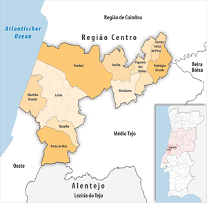
Region of Leiria
| Region of Leiria | |
|---|---|

|
|
| Basic data | |
| Country |
|
| region | Centro Region |
| Capital | Leiria |
| population | 294,629 (2013) |
| Population density | 120.3 inhabitants per km² |
| surface | 2,449.10 km² |
| Circles | 10 |
| Communities | 67 |
| ISO-3166-2 code | PT-16F |
Região de Leiria is a Portuguese sub-region and part of the Região Norte region . It is part of the Leiria district . Médio Tejo borders in the north on Região de Coimbra , in the south-east on Médio Tejo , in the south on Lezíria do Tejo , in the south-west on Oeste and in the north-west on the Atlantic Ocean .
Médio Tejo consists of 10 circles:
| circle | Number of municipalities |
Population (2011) |
Area km² |
Density of population / km² |
LAU code |
District |
|---|---|---|---|---|---|---|
| Alvaiázere | 5 | 7,287 | 160.47 | 45 | 1002 | Leiria |
| Ansião | 6th | 13.092 | 176.09 | 74 | 1003 | Leiria |
| Batalha | 4th | 15,805 | 103.42 | 153 | 1004 | Leiria |
| Castanheira de Pera | 1 | 3.191 | 66.77 | 48 | 1007 | Leiria |
| Figueiró dos Vinhos | 4th | 6,169 | 173.44 | 36 | 1008 | Leiria |
| Leiria | 18th | 126,884 | 565.08 | 225 | 1009 | Leiria |
| Marinha Grande | 3 | 38,699 | 187.25 | 207 | 1010 | Leiria |
| Pedrógão Grande | 3 | 3,915 | 128.75 | 30th | 1013 | Leiria |
| Pombal | 13 | 55,245 | 626.00 | 88 | 1015 | Leiria |
| Porto de Mós | 10 | 24,342 | 261.83 | 93 | 1016 | Leiria |
| Region of Leiria | 67 | 294,629 | 2,449.10 | 120 | 16F | - |