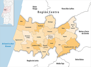
Region of Coimbra
| Region of Coimbra | |
|---|---|

|
|
| Basic data | |
| Country |
|
| region | Centro Region |
| Capital | Guarda |
| population | 460,137 (2013) |
| Population density | 106.1 inhabitants per km² |
| surface | 4,335.57 km² |
| Circles | 19th |
| Communities | 168 |
| ISO-3166-2 code | PT-16E |
Região de Coimbra is a statistical sub-region of Portugal . It is part of the Centro Região and belongs to the Aveiro , Coimbra and Viseu districts . Região de Coimbra borders in the north on Baixo Vouga and Viseu Dão-Lafões , in the east on Beiras e Serra da Estrela , in the south on Beira Baixa , Médio Tejo and Região de Leiria and in the west on the Atlantic Ocean .
The sub-region is divided into 19 districts:
| circle | Number of municipalities |
Population (2011) |
Area km² |
Density of population / km² |
LAU code |
District |
|---|---|---|---|---|---|---|
| Arganil | 14th | 12,143 | 332.85 | 36 | 0601 | Coimbra |
| Cantanhede | 14th | 36,595 | 390.88 | 94 | 0602 | Coimbra |
| Coimbra | 18th | 143,396 | 319.39 | 449 | 0603 | Coimbra |
| Condeixa-a-Nova | 7th | 17,078 | 138.67 | 123 | 0604 | Coimbra |
| Figueira da Foz | 14th | 62.125 | 379.04 | 164 | 0605 | Coimbra |
| Góis | 4th | 4,260 | 263.30 | 16 | 0606 | Coimbra |
| Lousã | 4th | 17,604 | 138.40 | 127 | 0607 | Coimbra |
| Mealhada | 6th | 20,428 | 110.65 | 185 | 0111 | Aveiro |
| Mira | 4th | 12,465 | 124.03 | 100 | 0608 | Coimbra |
| Miranda do Corvo | 4th | 13,098 | 126.38 | 104 | 0609 | Coimbra |
| Montemor-o-Velho | 11 | 26,171 | 228.97 | 114 | 0610 | Coimbra |
| Mortágua | 7th | 9,607 | 251.19 | 38 | 1808 | Viseu |
| Oliveira do Hospital | 16 | 20,855 | 234.52 | 89 | 0611 | Coimbra |
| Pampilhosa da Serra | 8th | 4,481 | 396.48 | 11 | 0612 | Coimbra |
| Penacova | 8th | 15,251 | 216.75 | 70 | 0613 | Coimbra |
| Penela | 4th | 5,983 | 134.79 | 44 | 0614 | Coimbra |
| Soure | 10 | 19,245 | 265.05 | 73 | 0615 | Coimbra |
| Tábua | 11 | 12,071 | 199.78 | 60 | 0616 | Coimbra |
| Vila Nova de Poiares | 4th | 7,281 | 84.45 | 86 | 0617 | Coimbra |
| Region of Coimbra | 168 | 460.137 | 4,335.57 | 106 | 16E | - |