Condeixa-a-Nova
| Condeixa-a-Nova | ||||||
|---|---|---|---|---|---|---|
|
||||||
| Basic data | ||||||
| Region : | Centro | |||||
| Sub-region : | Region of Coimbra | |||||
| District : | Coimbra | |||||
| Concelho : | Condeixa-a-Nova | |||||
| Freguesia : | União das Freguesias de Condeixa-a-Velha e Condeixa-a-Nova | |||||
| Coordinates : | 40 ° 7 ′ N , 8 ° 30 ′ W | |||||
| District of Condeixa-a-Nova | ||||||
|
||||||
| Residents: | 17,078 (as of June 30, 2011) | |||||
| Surface: | 138.67 km² (as of January 1, 2010) | |||||
| Population density : | 123 inhabitants per km² | |||||
| Number of municipalities : | 7th | |||||
| administration | ||||||
| Administration address: | Câmara Municipal de Condeixa-a-Nova Largo Artur Barreto 3150-124 Condeixa-a-Nova |
|||||
| Website: | www.cm-condeixa.pt | |||||
Condeixa-a-Nova is a district and a vila (small town) in Portugal with 5160 inhabitants (as of June 30, 2011).
On September 29, 2013, the municipalities of Condeixa-a-Nova and Condeixa-a-Velha merged to form the new municipality of União das Freguesias de Condeixa-a-Velha e Condeixa-a-Nova . Condeixa-a-Nova is the seat of this newly formed community.
history
At the time of the Roman occupation, Conimbriga was a major city in the province of Lusitania , but not of particular national importance. After the Suebi invaded here in the 5th century , the Arabs conquered the area in the 8th century . During the 7th / 8th In the 19th century, the inhabitants of Conimbriga left their city and founded Condeixa, today's Condeixa-a-Velha (German roughly: Old Condeixa). In the course of the Reconquista , D.Afonso Henriques conquered the area and handed it over to the Santa Cruz Monastery in Coimbra . The monks then founded Condeixa-a-Nova (English: New Condeixa). The first official mention of Condeixa-a-Nova comes from 1219.
King Manuel I granted the place city rights ( Foral ) for the first time in 1514 and elevated it to Vila (small town). In 1541 it became its own community. In the course of the Napoleonic Wars on the Iberian Peninsula , the place suffered severe destruction by French troops in 1811 and fell into disrepair. With the victory of the Liberal Revolution in Portugal in 1822, the place began to grow again. In 1838, Condeixa-a-Nova became an independent circle, at the request of Queen Maria II , and in 1845 it was raised again to Vila .
administration
District of Condeixa-a-Nova
 Condeixa-a-Nova is the seat of a district of the same name. The neighboring areas are (starting clockwise in the north): Coimbra , Miranda do Corvo , Penela , Soure and Montemor-o-Velho .
With the regional reform in September 2013, several municipalities were merged into new municipalities, so that the number of municipalities decreased from ten to seven.
The following municipalities ( Freguesias ) are in the Condeixa-a-Nova district:
| local community | Population (2011) |
Area km² |
Density of population / km² |
LAU code |
|---|---|---|---|---|
| Anobra | 1,316 | 16.38 | 80 | 060401 |
| Condeixa-a-Velha e Condeixa-a-Nova | 8,608 | 27.65 | 311 | 060411 |
| Ega | 2,835 | 32.55 | 87 | 060406 |
| Furadouro | 206 | 14.41 | 14th | 060407 |
| Sebal e Belide | 2,723 | 12.99 | 210 | 060412 |
| Vila Seca e Bem da Fé | 988 | 16.27 | 61 | 060413 |
| Zambujal | 402 | 18.42 | 22nd | 060410 |
| District of Condeixa-a-Nova | 17,078 | 138.67 | 123 | 0604 |
Population development
| Population in the district of Condeixa-a-Nova (1849–2011) | ||||||||
|---|---|---|---|---|---|---|---|---|
| 1849 | 1900 | 1930 | 1960 | 1981 | 1991 | 2001 | 2011 | |
| 8,733 | 11,875 | 12,149 | 13,555 | 13,257 | 13,027 | 15,340 | 17,078 | |
Town twinning
-
 Germany : Bretten (since 1985 )
 -
 France : Longjumeau (since 1993 )
 -
 United Kingdom : Pontypool (since 1999 )
 -
 Portugal : Idanha-a-Nova
traffic
Condeixa-a-Nova is located on the A1 motorway (with its own exit) and the IC2 and IC3 thoroughfares. The nearest train stops are in Taveiro, 11 km away, and Soure, 13 km away .
Culture and sights
With Conimbriga most important Portuguese archaeological site of the Roman occupation in the county Condeixa-a-Nova is located.
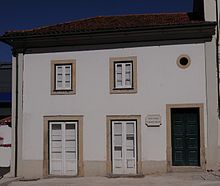
In 1990, the Casa-Museu Fernando Namora, a museum dedicated to the life and work of the writer, was opened in Fernando Namora's birthplace .
A range of plants and animals can be seen in the Paul de Arzila Wetland , a nature reserve with a visitor center, nature trails and guided walks, including otters , migratory birds and species of herons .
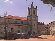
Among the almost 97 registered monuments of the community are mansions , fountains, historical public and private buildings as well as various sacred buildings , such as the single-nave main church with two side chapels and elements of Manueline , Renaissance and classicism , the Igreja Paroquial , built around 1517 de Condeixa-a-Nova (also Igreja de Santa Cristina ).
Sons and daughters
- João Franco de Oliveira (1642–1715), Archbishop of the Diocese of Bahia
- Antão de Almada (1718–1797), colonial administrator
- Rodrigo da Fonseca Magalhães (1787–1858), liberal politician, multiple minister
- Joaquim dos Santos e Silva (1842–1906), pharmacist and chemist
- Pedro Teixeira (1857–1925), mathematician
- Fernando Namora (1919–1989), writer
Web links
- Map of the Freguesia Condeixa-a-Nova at the Instituto Geográfico do Exército
- Official website
Individual evidence
- ↑ www.ine.pt - indicator resident population by place of residence and sex; Decennial in the database of the Instituto Nacional de Estatística
- ↑ Overview of code assignments from Freguesias on epp.eurostat.ec.europa.eu
- ^ Publication of the administrative reorganization in the Diário da República gazette of January 28, 2013, accessed on October 1, 2014
- ↑ www.verportugal.net , accessed December 28, 2012
- ^ Publication of the administrative reorganization in the Diário da República gazette of January 28, 2013, accessed on March 16, 2014
- ↑ www.anmp.pt , accessed December 28, 2012
- ↑ www.verportugal.net , accessed December 28, 2012
- ↑ www.monumentos.pt , accessed on December 28, 2012
| ← Previous location: Ansião |
|
Next town: Coimbra → |


