Pampilhosa da Serra
| Pampilhosa da Serra | ||||||
|---|---|---|---|---|---|---|
|
||||||
| Basic data | ||||||
| Region : | Centro | |||||
| Sub-region : | Region of Coimbra | |||||
| District : | Coimbra | |||||
| Concelho : | Pampilhosa da Serra | |||||
| Coordinates : | 40 ° 3 ′ N , 7 ° 57 ′ W | |||||
| Residents: | 1389 (as of June 30, 2011) | |||||
| Surface: | 100.18 km² (as of January 1, 2010) | |||||
| Population density : | 14 inhabitants per km² | |||||
| Postal code : | 3320 | |||||
| politics | ||||||
| Mayor : | José Alberto Pacheco Brito Dias ( PSD ) | |||||
| Address of the municipal administration: | Junta de Freguesia de Pampilhosa da Serra 3320-229 Pampilhosa da Serra |
|||||
| Website: | www.freguesias.pt/freguesia.php?cod=061206 | |||||
| Pampilhosa da Serra county | ||||||
|
||||||
| Residents: | 4481 (as of June 30, 2011) | |||||
| Surface: | 396.48 km² (as of January 1, 2010) | |||||
| Population density : | 11 inhabitants per km² | |||||
| Number of municipalities : | 8th | |||||
| administration | ||||||
| Administration address: | Câmara Municipal de Pampilhosa da Serra Rua Rangel de Lima 3320-229 Pampilhosa da Serra |
|||||
| Website: | www.cm-pampilhosadaserra.pt | |||||
Pampilhosa da Serra is a vila (small town) and a district ( concelho ) in Portugal with 1389 inhabitants (as of June 30, 2011).
history
The first traces of human settlement can be found here from the end of the second and beginning of the first millennium BC. The current place was first mentioned in 1241 AD. In 1308 King D Dinis elevated the place to a vila and gave it city rights ( Foral ). The place had to give up its status several times against his resistance and was subsequently annexed to Covilhã several times until it was finally declared an independent vila in 1399 by King D. João I.
In 1513 King Manuel I renewed the town charter .
administration
circle
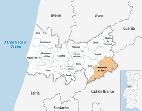
Pampilhosa da Serra is the administrative seat of a district of the same name. The neighboring districts are (starting clockwise in the north): Arganil , Covilhã , Fundão , Oleiros , Sertã , Pedrógão Grande and Góis .
With the regional reform in September 2013 , the four municipalities of Fajão , Vidual , Portela do Fojo and Machio were merged into two new municipalities, so that the number of municipalities decreased from ten to eight.
The following municipalities ( freguesias ) are in the Pampilhosa da Serra district:
| local community | Population (2011) |
Area km² |
Density of population / km² |
LAU code |
|---|---|---|---|---|
| Cabril | 231 | 35.20 | 7th | 061201 |
| Dornelas do Zezere | 682 | 16.44 | 41 | 061202 |
| Fajão - Vidual | 317 | 79.59 | 4th | 061211 |
| Janeiro de Baixo | 669 | 40.70 | 16 | 061204 |
| Pampilhosa da Serra | 1,389 | 100.18 | 14th | 061206 |
| Pessegueiro | 228 | 32.00 | 7th | 061207 |
| Portela do Fojo - Machio | 507 | 52.80 | 10 | 061212 |
| Unhais-o-Velho | 458 | 39.57 | 12 | 061209 |
| Pampilhosa da Serra county | 4,481 | 396.48 | 11 | 0612 |
Population development
| Population in Pampilhosa da Serra County (1801–2011) | |||||||||
|---|---|---|---|---|---|---|---|---|---|
| 1801 | 1849 | 1900 | 1930 | 1960 | 1981 | 1991 | 2001 | 2011 | |
| 3,260 | 4.163 | 12,426 | 13,459 | 13,372 | 7,493 | 5,797 | 5,220 | 4,487 | |
Municipal holiday
- 10th of April
Culture, sports and sights
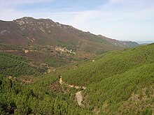
In the circle are two of the traditional slate villages, the Aldeias do Xisto . Thematically ordered, both local and regional hiking trails lead through the district.
In the whole district nature-oriented rural tourism is offered, and hunting tourism is also important, especially through the agency Serracaça - Sociedade Cinegética e Turística de Pampilhosa da Serra, Lda in Fajão .
A mountain bike center, the Centro BTT, has been set up in Pampilhosa da Serra . It offers bathing facilities, special rooms and services, and is the starting point for various bike trails with a length of 122 km.
The Barragem Santa Luzia reservoir offers a wide range of swimming and water sports. Also birdwatching is possible here.
The football club Grupo Desportivo Pampilhosense , the water sports club Clube Náutico , and the hunting and fishing club Associação do Clube de Caça e Pesca MBL are the most important sports clubs in the district.
In the circle you can see 20 listed buildings, mainly sacred buildings , in particular the parish church Igreja Paroquial da Pampilhosa da Serra (also Igreja de Nossa Senhora do Pranto ) with an altarpiece from the 16th century.
sons and daughters of the town
- Fernando Brito (* 1957), painter
- António Fernandes (* 1962), chess player
- Tony Carreira (* 1963), Portuguese singer (from Armadoura in the municipality of Cabril)
Web links
- Map of the Freguesia Pampilhosa da Serra at the Instituto Geográfico do Exército
- Official website
- Page with different picture galleries from Pampilhosa da Serra
Individual evidence
- ↑ www.ine.pt - indicator resident population by place of residence and sex; Decennial in the database of the Instituto Nacional de Estatística
- ↑ a b Overview of code assignments from Freguesias on epp.eurostat.ec.europa.eu
- ↑ www.ine.pt - indicator resident population by place of residence and sex; Decennial in the database of the Instituto Nacional de Estatística
- ↑ www.verportugal.net , accessed December 28, 2012
- ^ Publication of the administrative reorganization in the Diário da República gazette of January 28, 2013, accessed on March 16, 2014
- ↑ www.cm-pampilhosadaserra.pt ( Memento of the original from November 5, 2013 in the Internet Archive ) Info: The archive link was automatically inserted and not yet checked. Please check the original and archive link according to the instructions and then remove this notice. , accessed December 28, 2012
- ↑ ditto ( Memento of the original from November 5, 2013 in the Internet Archive ) Info: The archive link was automatically inserted and not yet checked. Please check the original and archive link according to the instructions and then remove this notice.
- ↑ www.monumentos.pt , accessed on December 28, 2012


