
Lousã
| Lousã | ||||||
|---|---|---|---|---|---|---|
|
||||||
| Basic data | ||||||
| Region : | Centro | |||||
| Sub-region : | Region of Coimbra | |||||
| District : | Coimbra | |||||
| Concelho : | Lousã | |||||
| Coordinates : | 40 ° 7 ′ N , 8 ° 15 ′ W | |||||
| Residents: | 10,139 (as of June 30, 2011) | |||||
| Surface: | 47.1 km² (as of January 1, 2010) | |||||
| Population density : | 215 inhabitants per km² | |||||
| Lousã district | ||||||
|
||||||
| Residents: | 17,604 (as of June 30, 2011) | |||||
| Surface: | 138.4 km² (as of January 1, 2010) | |||||
| Population density : | 127 inhabitants per km² | |||||
| Number of municipalities : | 4th | |||||
| administration | ||||||
| Administration address: | Câmara Municipal de Lousã Rua Dr. João Santos 3200-953 Lousã |
|||||
| President of the Câmara Municipal: | Luís Antunes ( PS ) | |||||
| Website: | www.cm-lousa.pt | |||||


Lousã is a small town ( vila ) in Portugal . It is located about 25 km southeast of Coimbra .

history

Various traces have been preserved from the time of the Roman occupation, from coins and household items to graves and building materials to pavement. The first post-Roman mention of the place comes from the year 943, in an agreement between Zuleima Abaiud and the abbot of the monastery of Lorvão. The name Arauz has been preserved in Arouce Castle, which can be visited in Lousã. Arouce first received administrative rights ("Foral") in 1151 from Portugal's first king, Dom Afonso Henriques .
A place called Lousã next to Arouce is mentioned for the first time in 1160. As the Middle Ages went on, the town continued to grow and Lousã was granted town charter in 1513.
In 1811 the place was plundered during the passage of General André Masséna's French army , in the course of the Napoleonic invasions .
From the middle of the 19th century the place saw a strong development due to the emerging industry, especially paper mills. The hospital (1888), the slaughterhouse (1896) and the theater were built. The onset of waves of emigration inhibited further development until the opening of the railway connection to Coimbra in 1906 broke the isolation and triggered new impulses, such as the electrification of the place in 1924.
Attractions

For a long time, the Lousã station was a very attractive sight for tourists with its historic loading crane on the disused loading platform and the wooden warehouse, which was probably built at the beginning of the 20th century. The barrack was demolished in 2008; in their place there is now a street. The station decorated with azulejos is still in operation.
With the Ecomuseu da Serra da Lousã there is a museum of the surrounding foothills of the Iberian Scheidegebirge , the Serra da Lousã , and its traditional "slate villages". Some of these belong to the Aldeias do Xisto route and have dark slate in common as the main building material. Extensive hiking trails are laid out in the Serra, which climbs up to 1202 meters.
The various mansions and the main church ( Igreja Matriz ) decorated with azulejos are also worth seeing.
Since 2019 there is also the circus museum "MOMO" in the municipality of Foz de Arruze. Museum director Detlef Schektiven and his partner Eva Cabral have put together a great collection of circus items from all over the world in a former school. Great shows are always offered in a small circus tent.
traffic

train
The place was the original end point of the Ramal da Lousã and becomes an important station of the Metro Mondego . In the meantime, a replacement rail service with buses has been set up.
bus
Lousã is integrated into the national bus network of Rede Expressos .
highway
The place is connected to the IC2 and A1 via the EN17 .
administration

Lousã district
Lousã is the seat of a district of the same name ( concelho ) in the Coimbra district . On June 30, 2011, the district had 17,604 inhabitants on an area of 138.4 km².
The neighboring districts are (starting in the north clockwise): Vila Nova de Poiares , Góis , Castanheira de Pêra , Figueiró dos Vinhos and Miranda do Corvo .
With the regional reform in September 2013, several municipalities were merged into new municipalities, so that the number of municipalities decreased from six to four.
The following municipalities ( freguesias ) are in the Lousã district:

| local community | Population (2011) |
Area km² |
Density of population / km² |
LAU code |
|---|---|---|---|---|
| Foz de Arouce e Casal de Ermio | 1,438 | 19.84 | 72 | 060707 |
| Gândaras | 1,308 | 10.04 | 130 | 060706 |
| Lousã e Vilarinho | 13,056 | 72.40 | 180 | 060708 |
| Serpins | 1,802 | 36.12 | 50 | 060704 |
| Lousã district | 17,604 | 138.40 | 127 | 0607 |
Population development
| Population in Lousã County (1801–2011) | |||||||||||
|---|---|---|---|---|---|---|---|---|---|---|---|
| 1801 | 1849 | 1900 | 1930 | 1960 | 1981 | 1991 | 2001 | 2004 | 2006 | 2008 | 2011 |
| 6,574 | 10,275 | 11,685 | 12,905 | 13,900 | 13,020 | 13,447 | 15,753 | 17,252 | 18,273 | 19,293 | 17,380 |
Municipal holiday
- June 24th
Town twinning
Lousã is with the French community Prades since 1991 through a twinning connected.
.png)

sons and daughters of the town
- Vicente Ferrer Neto Paiva (1798–1886), university professor and politician after the Miguelistenkrieg , introduced panentheism in Portugal
- Francisco Maria Supico (1830–1911), journalist, politician and Freemason
- Francisco José Fernandes Costa (1867–1925), Republican politician, Prime Minister
- Carlos Alberto Vidal (born 1954), singer
- Nuno Assis (* 1977), soccer player
Web links
- Map of the Freguesia Lousã at the Instituto Geográfico do Exército
- Official website of the city administration
Individual evidence
- ↑ www.ine.pt - indicator resident population by place of residence and sex; Decennial in the database of the Instituto Nacional de Estatística
- ↑ a b Overview of code assignments from Freguesias on epp.eurostat.ec.europa.eu
- ↑ a b www.ine.pt - indicator resident population by place of residence and sex; Decennial in the database of the Instituto Nacional de Estatística
- ↑ Archived copy ( Memento of the original from January 14, 2012 in the Internet Archive ) Info: The archive link was inserted automatically and has not yet been checked. Please check the original and archive link according to the instructions and then remove this notice.
- ^ Publication of the administrative reorganization in the Diário da República gazette of January 28, 2013, accessed on March 16, 2014
- ^ Prades website
gallery
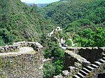
The Church of Sra. da Piedade seen from the castle

River bath
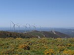
Wind farm in the Serra da Lousã
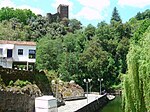
River bath with the castle in the background


Arganil | Cantanhede | Coimbra | Condeixa-a-Nova | Figueira da Foz | Góis | Lousã | Mira | Miranda do Corvo | Montemor-o-Velho | Oliveira do Hospital | Pampilhosa da Serra | Penacova | Penela | Soure | Tábua | Vila Nova de Poiares