
Sertã
| Sertã | ||||||
|---|---|---|---|---|---|---|
|
||||||
| Basic data | ||||||
| Region : | Centro | |||||
| Sub-region : | Médio Tejo | |||||
| District : | Castelo Branco | |||||
| Concelho : | Sertã | |||||
| Coordinates : | 39 ° 48 ′ N , 8 ° 6 ′ W | |||||
| Residents: | 6196 (as of June 30, 2011) | |||||
| Surface: | 80.95 km² (as of January 1, 2010) | |||||
| Population density : | 77 inhabitants per km² | |||||
| politics | ||||||
| Website: | www.jfserta.pt | |||||
| Sertã district | ||||||
|
||||||
| Residents: | 15,880 (as of June 30, 2011) | |||||
| Surface: | 446.73 km² (as of January 1, 2010) | |||||
| Population density : | 36 inhabitants per km² | |||||
| Number of municipalities : | 10 | |||||
| administration | ||||||
| Administration address: | Câmara Municipal de Sertã Largo do Município 6100-738 Sertã |
|||||
| President of the Câmara Municipal: | José Farinha Nunes | |||||
| Website: | www.cm-serta.pt | |||||


Sertã [ sɯɾˈtɐ̃ ] is a small town ( Vila ) and a district ( Concelho ) in Portugal with 6196 inhabitants (as of June 30, 2011).
history

The stake ( Pelourinho ), symbol of the granted city rights (1513)
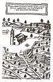
Sertã (engraving from 1640)
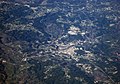
Aerial view of Sertã and its district

View over the municipality of Figueiredo


Finds and excavations, including Antas , prove a settlement of the place at least since the Castro culture . Lusitans lived here when the Romans built a Lusitania Province site and bridge in the first century . The Arabs built a castle here. During the Reconquista and the independence of the Kingdom of Portugal after 1139 , Portugal's first king, D.Afonso Henriques , gave the place to the Knights Templar from 1165 to 1174 before handing it over to the Order of Hospital (now the Sovereign Order of Malta ). In the Revolution in 1383 , in which the entitled to inherit the kingdom of Castile sought to annex Portugal, the place was on the side of the Portuguese independence movement under the following King D.João I . In 1455 Sertã became the Vila raised (town) before its first town charter ( Foral ) in 1513 by King Manuel I received. Until the spelling reform in 1911 , the place was now written Certã .
The founding legend of the place
The place is said to have been in the year 74 BC. BC by Quintus Sertorius , who was the leader of the Celtiberian Lusitanians, and had a castle built here. In an attack by the Romans, the then commander of the castle is said to have been killed. His wife Celinda, who stormed out of the kitchen, is said to have climbed onto the castle walls and poured her square pan (the Sertage ) with hot oil over the oncoming Romans, thus surprising and stopping them until the forces hurried to help from the neighboring towns arrived, to drive away the attackers. The place is said to have been called "place of the Sertage", Sertã .
Culture, sports and sights
The numerous architectural monuments of Sertã include various sacred buildings , historical public buildings, and the castle, as well as the Roman bridge. The historic town center as a whole is also a listed building. At various archaeological excavation sites in the district you can u. a. See rock paintings ( Portuguese : Arte rupreste ).
In addition to the municipal library Biblioteca Municipal Padre Manuel Antunes , the cultural center Clube de Sertã , and the event and cultural complex Casa de Espetáculos e da Cultura da Sertã in the district town of Sertã, there is another notable cultural site in Cernache do Bonjardim with the artist house Atelier Túllio Victorino in a circle.
With Pedrógão Pequeno is located in the district of one of the traditional slate villages in the region, the Aldeias do Xisto . Hiking trails connect them. The football club Sertanense Futebol Clube is the most important sports club in the district. He plays in the third division (group south, port: Série Sul ) and also runs athletics and sport fishing sections.
administration
circle
Sertã is the administrative seat of a district of the same name. The neighboring districts are (starting clockwise in the north): Pampilhosa da Serra , Oleiros , Proença-a-Nova , Mação , Vila de Rei , Ferreira do Zêzere , Figueiró dos Vinhos and Pedrógão Grande .
With the regional reform in September 2013 , several municipalities were merged into new municipalities, so that the number of municipalities decreased from 14 to ten.
The following municipalities ( freguesias ) are in the Sertã district:

| local community | Population (2011) |
Area km² |
Density of population / km² |
LAU code |
|---|---|---|---|---|
| Cabeçudo | 957 | 10.39 | 92 | 050901 |
| Carvalhal | 465 | 10.02 | 46 | 050902 |
| Carvalhal | 1,046 | 24.57 | 43 | 050903 |
| Cernache do Bonjardim, Nesperal e Palhais | 3,625 | 101.59 | 36 | 050915 |
| Cumeada e Marmeleiro | 731 | 51.73 | 14th | 050916 |
| Ermida e Figueiredo | 423 | 42.74 | 10 | 050917 |
| Pedrógão Pequeno | 753 | 36.86 | 20th | 050911 |
| Sertã | 6,196 | 80.95 | 77 | 050912 |
| Troviscal | 864 | 53.37 | 16 | 050913 |
| Várzea dos Cavaleiros | 820 | 34.51 | 24 | 050914 |
| Sertã district | 15,880 | 446.73 | 36 | 0509 |
Population development
| Population of Sertã (1801-2004) | ||||||||
|---|---|---|---|---|---|---|---|---|
| 1801 | 1849 | 1900 | 1930 | 1960 | 1981 | 1991 | 2001 | 2004 |
| 10,235 | 13,456 | 20,380 | 24,057 | 27,997 | 21,503 | 18.199 | 16,720 | 16,208 |
Municipal holiday
- June 24th
Sons and daughters of Sertã
- Nuno Álvares Pereira (1360–1431), canonized military leader (from Cernache do Bonjardim)
- Jacinto Leitão Manso de Lima (* 1690), genealogist
- António Lopes dos Santos Valente (1839–1896), poet, philosopher and literary critic
- Casimiro Freire (1843–1918), industrialist, businessman and philanthropist
- David Lopes (1867–1942), historian, author, professor of French literature and especially Arabic studies (from Nesperal)
- Albano Augusto de Portugal Durão (1871–1925), general and politician, Republican finance minister and then foreign minister
- Silvino Santos (1886–1970), Portuguese-Brazilian photographer (from Cernache do Bonjardim)
- Manuel Antunes (1918–1985), pastor, university professor, educator and author
- Pedro Rosa Mendes (* 1968), journalist and author, intellectual (from Cernache do Bonjardim)
literature
- Thomas G. Schattner (Ed.): Archaeological guide through Portugal (= cultural history of the ancient world . Vol. 74). Philipp von Zabern, Mainz 1998, ISBN 3-8053-2313-1 p. 115
Individual evidence
- ↑ www.ine.pt - indicator resident population by place of residence and sex; Decennial in the database of the Instituto Nacional de Estatística
- ↑ a b Overview of code assignments from Freguesias on epp.eurostat.ec.europa.eu
- ↑ www.ine.pt - indicator resident population by place of residence and sex; Decennial in the database of the Instituto Nacional de Estatística
- ↑ www.cm-serta.pt , accessed on February 14, 2013
- ↑ a b www.verportugal.net , accessed on February 14, 2013
- ↑ www.cm-serta.pt , accessed on February 14, 2013
- ↑ www.monumentos.pt , accessed on February 14, 2013
- ↑ ditto
- ^ Publication of the administrative reorganization in the Diário da República gazette of January 28, 2013, accessed on March 16, 2014
Web links
- Map of the Freguesia Sertã at the Instituto Geográfico do Exército
- Official website
- Official visitor site of the city administration

Belmonte | Castelo Branco | Covilhã | Fundão | Idanha-a-Nova | Oleiros | Penamacor | Proença-a-Nova | Sertã | Vila de Rei | Vila Velha de Ródão