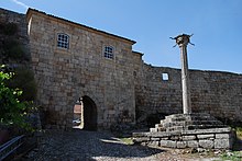
Penamacor
| Penamacor | ||||||
|---|---|---|---|---|---|---|
|
||||||
| Basic data | ||||||
| Region : | Centro | |||||
| Sub-region : | Viseu Dão-Lafoes | |||||
| District : | Castelo Branco | |||||
| Concelho : | Penamacor | |||||
| Coordinates : | 40 ° 10 ′ N , 7 ° 10 ′ W | |||||
| Residents: | 1577 (as of June 30, 2011) | |||||
| Surface: | 373.5 km² (as of January 1, 2010) | |||||
| Population density : | 4.2 inhabitants per km² | |||||
| Penamacor County | ||||||
|
||||||
| Residents: | 5682 (as of June 30, 2011) | |||||
| Surface: | 563.72 km² (as of January 1, 2010) | |||||
| Population density : | 10 inhabitants per km² | |||||
| Number of municipalities : | 9 | |||||
| administration | ||||||
| Administration address: | Câmara Municipal de Penamacor Largo do Município 6090-543 Penamacor |
|||||
| President of the Câmara Municipal: | Domingos Manuel Bicho Torrão ( PS ) | |||||
| Website: | www.cm-penamacor.pt | |||||
Penamacor (also Penamacôr ) is a small town ( Vila ) and a district in Portugal with 1577 inhabitants (as of June 30, 2011). The place belongs to the Rede de Judiarias ( Portuguese for: Network of the Jewish Quarter), a network of places with historically significant Jewish communities.
history
The Visigoth king Vamba comes from Penamacor according to unproven suspicions. The place received its first town charter ( Foral ) in 1189 by King Sancho I , who gave Penamacor to Gualdim Pais . The place grew with the beginning settlement policy and gained importance due to its strategic position in the defense line against Aragon and Castile . It was fortified with castles and elevated to Vila (small town with administrative rights) in 1199. In 1217 King D.Afonso II confirmed the town charter , which King Manuel I renewed in 1510.
administration
The circle
Penamacor is the seat of a district of the same name ( concelho ) in the Castelo Branco district . On June 30, 2011, the district had 5682 inhabitants on an area of 563.7 km².
In the east, the district borders on Spain , the Portuguese neighboring districts are (starting clockwise in the north): Sabugal , Idanha-a-Nova , Castelo Branco and Fundão .
With the regional reform in September 2013 , several municipalities were merged into new municipalities, so that the number of municipalities decreased from twelve to nine.
The following municipalities ( Freguesias ) are in the Penamacor district:
| local community | Population (2011) |
Area km² |
Density of population / km² |
LAU code |
|---|---|---|---|---|
| Aldeia do Bispo, Águas e Aldeia de João Pires | 1,171 | 32.71 | 36 | 050713 |
| Aranhas | 353 | 5.48 | 64 | 050704 |
| Benquerença | 575 | 28.60 | 20th | 050706 |
| Meimão | 280 | 33.12 | 8th | 050707 |
| Meimoa | 373 | 28.80 | 13 | 050708 |
| Pedrógão de São Pedro e Bemposta | 620 | 31.71 | 20th | 050714 |
| Penamacor | 1,577 | 373.50 | 4th | 050710 |
| Salvador | 476 | 10.49 | 45 | 050711 |
| Vale da Senhora da Póvoa | 257 | 19.31 | 13 | 050712 |
| District Fundão | 5,682 | 563.72 | 10 | 0507 |
Population development
| Population in Penamacor County (1801–2011) | |||||||||
|---|---|---|---|---|---|---|---|---|---|
| 1801 | 1849 | 1900 | 1930 | 1960 | 1981 | 1991 | 2001 | 2011 | |
| 5259 | 7498 | 13,179 | 15,724 | 16,659 | 9524 | 8115 | 6658 | 5652 | |
Municipal holiday
- Easter Monday
Town twinning
-
 France : Clamart in the Hauts-de-Seine department
-
 Spain : Valverde del Fresno in the province of Cáceres
sons and daughters of the town
- António Nunes Ribeiro Sanches (1699–1783), doctor, translator and encyclopedist, philosopher, educator and historian
- Teodora Alexandrina de Almeida de Lima Pais Castelo Branco (1809–1889), noble landowner and philanthropist
- Francisco Pinto da Cunha Leal (1888–1970), politician, Prime Minister in the winter of 1921/22
- Tarzan Taborda (1935-2005), wrestler
- Joaquim Furtado (* 1948), television journalist, father of Catarina Furtado
- António Manuel Moiteiro Ramos (* 1956), auxiliary bishop in Braga
- António José Seguro (* 1962), politician, General Secretary of the Partido Socialista since 2011
Web links
- Map of the Freguesia Penamacor at the Instituto Geográfico do Exército
- Official website
Individual evidence
- ↑ www.ine.pt - indicator resident population by place of residence and sex; Decennial in the database of the Instituto Nacional de Estatística
- ↑ a b Overview of code assignments from Freguesias on epp.eurostat.ec.europa.eu
- ↑ a b www.ine.pt - indicator resident population by place of residence and sex; Decennial in the database of the Instituto Nacional de Estatística
- ↑ www.verportugal.net , accessed January 27, 2013
- ^ Publication of the administrative reorganization in the Diário da República gazette of January 28, 2013, accessed on March 16, 2014
- ↑ geminacoes ( Memento from October 1, 2012 in the Internet Archive )


