Sabugal
| Sabugal | ||||||
|---|---|---|---|---|---|---|
|
||||||
| Basic data | ||||||
| Region : | Centro | |||||
| Sub-region : | Beiras e Serra da Estrela | |||||
| District : | Guarda | |||||
| Concelho : | Sabugal | |||||
| Coordinates : | 40 ° 21 ′ N , 7 ° 5 ′ W | |||||
| Residents: | 1901 (as of June 30, 2011) | |||||
| Surface: | 29.98 km² (as of January 1, 2010) | |||||
| Population density : | 63 inhabitants per km² | |||||
| politics | ||||||
| Address of the municipal administration: | Junta de Freguesia de Sabugal R. Cemitério Sabugal 6320-359 Sabugal |
|||||
| Sabugal County | ||||||
|
||||||
| Residents: | 12,544 (as of June 30, 2011) | |||||
| Surface: | 822.71 km² (as of January 1, 2010) | |||||
| Population density : | 15 inhabitants per km² | |||||
| Number of municipalities : | 30th | |||||
| administration | ||||||
| Administration address: | Câmara Municipal de Sabugal Praça da República 6324-007 Sabugal |
|||||
| President of the Câmara Municipal: | António dos Santos Robalo ( PSD ) | |||||
| Website: | www.cm-sabugal.pt | |||||
Sabugal is a municipality and city ( Cidade ) in Portugal with 1901 inhabitants (as of June 30, 2011). It belongs to the Rede de Judiarias , an association of places with historically significant Jewish communities, which u. a. operate a common tourism marketing. With the place Sortelha is also one of the historical villages ( Aldeias Históricas de Portugal ) in the district of Sabugal.
history
The city is located in the area of the Côa River with its archaeological sites of the Parque Arqueológico do Vale do Côa . In the urban area there are traces of human settlement up to the Neolithic Age . There are numerous finds from the Bronze Age , and various fortifications, metal and ceramic objects have been preserved from the Iron Age .
The whole area experienced an eventful history in the centuries after the end of the Roman occupation and was sometimes Moorish , sometimes it belonged to the Kingdom of León , and sometimes it was Portuguese, which has been formalized since the Treaty of Alcañices in 1297 and after numerous Castilian attacks until 1393 then in fact remained.
In the course of the administrative renewals, Sabugal received administrative rights ("Foral") and modernized fortifications from King Manuel .
On April 3, 1811, British and Portuguese troops defeated the Napoleonic invading army here and with this victory finally expelled the French from Portugal .
With the administrative reforms in the middle of the 19th century, the district ( concelho ) of Sabugal was created in 1855 , in which 40 municipalities ( freguesias ) were combined, including the previously independent districts Alfaiates , Vila do Touro , Sortelha and Vilar Maior .
administration
The circle
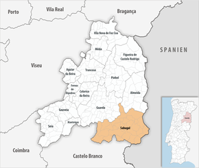
Sabugal is the seat of a district of the same name, which borders on Spain to the east . The neighboring areas are (starting counter-clockwise in the north): Almeida , Guarda , Belmonte , Fundão , and Penamacor .
With the regional reform in September 2013 , several municipalities were merged to form new municipalities, so that the number of municipalities decreased from 41 to 30.
The following municipalities ( freguesias ) are in Sabugal County:
| local community | Population (2011) |
Area km² |
Density of population / km² |
LAU code |
|---|---|---|---|---|
| Águas Belas | 175 | 20.57 | 9 | 091101 |
| Aldeia da Ponte | 317 | 36.69 | 9 | 091103 |
| Aldeia da Ribeira, Vilar Maior e Badamalos | 347 | 68.79 | 5 | 091141 |
| Aldeia do Bispo | 286 | 13.14 | 22nd | 091102 |
| Aldeia Velha | 431 | 20.88 | 21st | 091106 |
| Alfaiates | 331 | 31.43 | 11 | 091107 |
| Baraçal | 190 | 16.03 | 12 | 091109 |
| Bendada | 580 | 34.60 | 17th | 091110 |
| Bismula | 193 | 19.13 | 10 | 091111 |
| Casteleiro | 365 | 44.50 | 8th | 091112 |
| Cerdeira do Côa | 229 | 23.43 | 10 | 091113 |
| Fóios | 362 | 28.31 | 13 | 091114 |
| Lajeosa e Forcalhos | 289 | 28.93 | 10 | 091142 |
| Malcata | 332 | 21.25 | 16 | 091118 |
| Nave | 230 | 27.13 | 8th | 091120 |
| Pousafoles do Bispo, Pena Lobo e Lomba | 475 | 38.16 | 12 | 091143 |
| Quadrazais | 457 | 40.61 | 11 | 091123 |
| Quinta de Sao Bartolomeu | 180 | 10.64 | 17th | 091124 |
| Rapoula do Côa | 195 | 7.94 | 25th | 091125 |
| Rebolosa | 222 | 8.98 | 25th | 091126 |
| Rendo | 278 | 21.51 | 13 | 091127 |
| Ruvina, Ruivós e Vale das Éguas | 221 | 18.42 | 12 | 091144 |
| Sabugal e Aldeia de Santo António | 2,741 | 56.34 | 49 | 091145 |
| Santo Estêvão e Moita | 413 | 29.00 | 14th | 091146 |
| Seixo do Côa e Vale Longo | 218 | 25.03 | 9 | 091147 |
| Sortelha | 444 | 39.64 | 11 | 091133 |
| Souto | 1,224 | 28.09 | 44 | 091134 |
| Vale de Espinho | 393 | 31.61 | 12 | 091136 |
| Vila Boa | 243 | 8.62 | 28 | 091138 |
| Vila do Touro | 183 | 23.31 | 8th | 091139 |
| Sabugal County | 12,544 | 822.71 | 15th | 0911 |
Population development
| Population in the Sabugal district (1801–2011) | ||||||||||
|---|---|---|---|---|---|---|---|---|---|---|
| 1801 | 1849 | 1900 | 1930 | 1960 | 1981 | 1991 | 2001 | 2011 | ||
| 7157 | 11,669 | 33,047 | 33,774 | 38,062 | 18,927 | 16,919 | 14,871 | 12,544 | ||
Sons and daughters
- José Francisco Sanches Alves (* 1941), Archbishop of Évora
- Manuel António Pina (1943–2012), journalist and writer
- Joaquim Sapinho (* 1964), film director and producer
Web links
- Map of the Freguesia Sabugal at the Instituto Geográfico do Exército
- Official website
Individual evidence
- ↑ www.ine.pt - indicator resident population by place of residence and sex; Decennial in the database of the Instituto Nacional de Estatística
- ↑ a b Overview of code assignments from Freguesias on epp.eurostat.ec.europa.eu
- ↑ www.ine.pt - indicator resident population by place of residence and sex; Decennial in the database of the Instituto Nacional de Estatística
- ↑ www.cm-sabugal.pt ( Memento of the original from October 14, 2013 in the Internet Archive ) Info: The archive link was inserted automatically and has not yet been checked. Please check the original and archive link according to the instructions and then remove this notice. , accessed December 30, 2012
- ^ Publication of the administrative reorganization in the Diário da República gazette of January 28, 2013, accessed on March 16, 2014


