
Vila de Rei
| Vila de Rei | ||||||
|---|---|---|---|---|---|---|
|
||||||
| Basic data | ||||||
| Region : | Centro | |||||
| Sub-region : | Médio Tejo | |||||
| District : | Castelo Branco | |||||
| Concelho : | Vila de Rei | |||||
| Coordinates : | 39 ° 41 ′ N , 8 ° 9 ′ W | |||||
| Residents: | 2610 (as of June 30, 2011) | |||||
| Surface: | 141.95 km² (as of January 1, 2010) | |||||
| Population density : | 18 inhabitants per km² | |||||
| Postal code : | 6110 | |||||
| politics | ||||||
| Address of the municipal administration: | Junta de Freguesia de Vila de Rei Rua de St. António 6110 Vila de Rei |
|||||
| Vila de Rei county | ||||||
|
||||||
| Residents: | 3452 (as of June 30, 2011) | |||||
| Surface: | 191.54 km² (as of January 1, 2010) | |||||
| Population density : | 18 inhabitants per km² | |||||
| Number of municipalities : | 3 | |||||
| administration | ||||||
| Administration address: | Câmara Municipal de Vila de Rei Praça Familia Mattos e Silva Neves 6110-174 Vila de Rei |
|||||
| President of the Câmara Municipal: | Maria Irene da Conceição Barata Joaquim ( PSD ). | |||||
| Website: | www.cm-viladerei.pt | |||||


Vila de Rei is a vila (small town) in Portugal . It is the seat of a district of the same name ( concelho ) and a community of the same name ( freguesia ).
geography
The place is about 70 km from the eastern district capital Castelo Branco . It is also 23 km north of Abrantes and its connection to the A23 motorway.
The geographic center of continental Portugal is in Vila de Rei.
history
Vila de Rei received city rights ( Foral ) in 1285 by King Dionysius . During the 13th century, the settlement of the area was promoted by the Knights Templar and then the Order of Christ . King Manuel I renewed the town charter in 1513.
The place suffered looting and damage by the hand of passing Napoleonic troops during the French invasions in 1810 .
With the construction of the Castelo de Bode dam in 1950 and the rise of the Rio Zêzere , the district lost some parts of its area to the west. So eight villages went under in the rising water. Between 1986 and 2003 a series of forest fires raged and destroyed around 80% of the district's forest areas. Thanks to afforestation , the district has now been able to significantly enlarge its forest areas again.
Culture and sights

View of the Vila de Rei district

The geographic center of Portugal
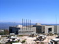
The Museu de Geodesia

Azulejo board at the geographical center of Portugal


With the Museu de Geodesia there is a museum on the geographical center of the country. In addition, a monument marks the exact geographical center.
In addition to a number of primarily ecclesiastical monuments, the entire historical town center , founded by the Knights Templar in the 13th century, is also a listed building.
In the municipality of Vila de Rei, the town of Água Formosa is one of the 27 special slate villages , the Aldeias do Xisto .
administration
circle
Vila de Rei is the administrative seat of a district of the same name. The neighboring regions are (starting clockwise in the north): Sertã , Mação , Sardoal , Abrantes and Ferreira do Zêzere .
The following municipalities ( freguesias ) are in the district of Vila de Rei:

| local community | Population (2011) |
Area km² |
Density of population / km² |
LAU code |
|---|---|---|---|---|
| Fundada | 638 | 36.54 | 17th | 051001 |
| Sao João do Peso | 204 | 13.05 | 16 | 051002 |
| Vila de Rei | 2,610 | 141.95 | 18th | 051003 |
| Vila de Rei county | 3,452 | 191.54 | 18th | 0510 |
Population development
| Population in Vila de Rei County (1801–2011) | ||||||||
|---|---|---|---|---|---|---|---|---|
| 1801 | 1849 | 1900 | 1930 | 1960 | 1981 | 1991 | 2001 | 2011 |
| 3 489 | 6 742 | 6 781 | 7 399 | 7 568 | 4,654 | 3 687 | 3 354 | 3 452 |
Municipal holiday
- September 19th
sons and daughters of the town
- António de Castro (1707–1743), Bishop of Malacca
- Sebastião José Pereira (1857–1925), bishop in Mozambique and Daman
- Mateus de Oliveira Xavier (1858–1929), Archbishop of Goa and Daman
- Manuel Nunes Gabriel (1912–1996), missionary, Archbishop of Luanda
- José Cardoso Pires (1925–1998), writer
Web links
- Map of the Freguesia Vila de Rei at the Instituto Geográfico do Exército
- Official website
Individual evidence
- ↑ www.ine.pt - indicator resident population by place of residence and sex; Decennial in the database of the Instituto Nacional de Estatística
- ↑ a b Overview of code assignments from Freguesias on epp.eurostat.ec.europa.eu
- ↑ The address of the community of Vila de Rei ( Memento of the original from June 4, 2010 in the Internet Archive ) Info: The archive link was inserted automatically and has not yet been checked. Please check the original and archive link according to the instructions and then remove this notice. on the page of the circle, Portuguese, accessed May 5, 2010
- ↑ Local election results list 2009 (pdf)
- ↑ www.ine.pt - indicator resident population by place of residence and sex; Decennial in the database of the Instituto Nacional de Estatística
- ↑ www.cm-viladerei.pt , accessed on November 24, 2012
- ↑ www.monumentos.pt , accessed on November 24, 2012

Belmonte | Castelo Branco | Covilhã | Fundão | Idanha-a-Nova | Oleiros | Penamacor | Proença-a-Nova | Sertã | Vila de Rei | Vila Velha de Ródão