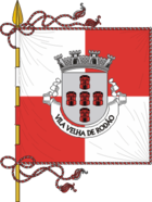
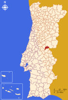
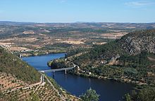
Vila Velha de Ródão
| Vila Velha de Ródão | ||||||
|---|---|---|---|---|---|---|
|
||||||
| Basic data | ||||||
| Region : | Centro | |||||
| Sub-region : | Beira Baixa | |||||
| District : | Castelo Branco | |||||
| Concelho : | Vila Velha de Ródão | |||||
| Coordinates : | 39 ° 39 ′ N , 7 ° 40 ′ W | |||||
| Residents: | 1766 (as of June 30, 2011) | |||||
| Surface: | 90.44 km² (as of January 1, 2010) | |||||
| Population density : | 20 inhabitants per km² | |||||
| Vila Velha de Ródão district | ||||||
|
||||||
| Residents: | 3521 (as of June 30, 2011) | |||||
| Surface: | 329.91 km² (as of January 1, 2010) | |||||
| Population density : | 11 inhabitants per km² | |||||
| Number of municipalities : | 4th | |||||
| administration | ||||||
| Administration address: | Câmara Municipal de Vila Velha de Ródão Rua Santana 6030-230 Vila Velha de Ródão |
|||||
| President of the Câmara Municipal: | Maria do Carmo Sequeira | |||||
| Website: | www.cm-vvrodao.pt | |||||
Vila Velha de Ródão is a small town ( Vila ) and a district ( concelho ) in Portugal with 1766 inhabitants (as of June 30, 2011).
history
Romans settled here since the 1st century AD. In the 7th century the place was part of the Visigoth Empire , a castle built here is attributed to King Wamba . In the course of the Reconquista , the local fortress on the Tagus had been a strategically important point of defense against the Moors since the 11th century .
The place belonged to a donation that King D.Sancho made to the Knights Templar in 1198 . In 1319 the area came to the order of Christ . Early 16th century, the pillory was erected in place as a sign of civic rights (obtained Foral ) by King Manuel I .
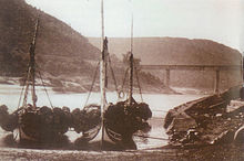
Vila Velha de Ródão was an important inland port for the region, but with the arrival of the railroad in 1885 it lost its importance as a logistical hub. The Celtejo paper mill , which opened in 1971 and later joined Portucel , became an important factor in the further development of the town .
Culture and sights
Among the monuments are historic public buildings that Paleolithic archaeological site Estação Arqueológica da Foz do Enxarrique , and various religious buildings , such as the three-nave, originally built in the 16th century, baroque - Mannerist parish church Igreja Paroquial de Vila Velha de Ródão (also Igreja de Nossa Senhora da Conceição ). The historic town center is also a listed building.
The municipal library Biblioteca Municipal José Baptista Martins , which opened in 2008, offers free WiFi internet, various rooms for readings and film screenings, and cross-generational internet, photography and yoga workshops in addition to its library services . In the urban cultural center Casa de Artes e Cultura do Tejo , u. a. changing art exhibitions shown.
administration
circle
Vila Velha de Ródão is the administrative seat of a district of the same name, which borders Spain in the southeast . The neighboring districts are (starting clockwise in the north): Castelo Branco , Nisa , Mação and Proença-a-Nova .
The following municipalities ( freguesias ) are in the district of Vila Velha de Ródão:
| local community | Population (2011) |
Area km² |
Density of population / km² |
LAU code |
|---|---|---|---|---|
| Fratel | 608 | 97.84 | 6th | 051101 |
| Perais | 510 | 81.95 | 6th | 051102 |
| Sarnadas de Ródão | 637 | 59.68 | 11 | 051103 |
| Vila Velha de Ródão | 1,766 | 90.44 | 20th | 051104 |
| Vila Velha de Ródão district | 3,521 | 329.91 | 11 | 0511 |
Population development
| Population in the district of Vila Velha de Ródão (1801–2011) | |||||||||
|---|---|---|---|---|---|---|---|---|---|
| 1801 | 1849 | 1900 | 1930 | 1960 | 1981 | 1991 | 2001 | 2011 | |
| 2,665 | 3,975 | 6 633 | 8 753 | 8 039 | 5 605 | 4,960 | 4 098 | 3,521 | |
traffic
Vila Velha de Ródão is located on the A23 motorway (Fratel exit) and has two stops on the Linha da Beira Baixa railway line, Fratel and Velha de Ródão . The place is also integrated into the national bus network of Rede Expressos .
sons and daughters of the town
- Armindo Rodrigues de Sttau Monteiro (1896–1955), politician and diplomat
- Manuel Cargaleiro (* 1927), painter and ceramic artist
- José Moura Nunes da Cruz (* 1936), judge, 2005 Chairman of the Supreme Court ( Supremo Tribunal de Justiça )
- José Nuno Martins (* 1948), TV producer, radio presenter and author
Web links
- Map of the Freguesia Vila Velha de Ródão at the Instituto Geográfico do Exército
- Official website
Individual evidence
- ↑ www.ine.pt - indicator resident population by place of residence and sex; Decennial in the database of the Instituto Nacional de Estatística
- ↑ a b Overview of code assignments from Freguesias on epp.eurostat.ec.europa.eu
- ↑ www.ine.pt - indicator resident population by place of residence and sex; Decennial in the database of the Instituto Nacional de Estatística
- ↑ www.monumentos.pt (under Cronologia ), accessed on February 2, 2013
- ↑ www.verportugal.net , accessed on February 2, 2013
- ↑ www.monumentos.pt , accessed on February 2, 2013
- ↑ ditto


