
Vila Nova da Barquinha
| Vila Nova da Barquinha | ||||||
|---|---|---|---|---|---|---|
|
||||||
| Basic data | ||||||
| Region : | Centro | |||||
| Sub-region : | Médio Tejo | |||||
| District : | Santarém | |||||
| Concelho : | Vila Nova da Barquinha | |||||
| Coordinates : | 39 ° 27 ′ N , 8 ° 26 ′ W | |||||
| Residents: | 1599 (as of June 30, 2011) | |||||
| Surface: | 6.02 km² (as of January 1, 2010) | |||||
| Population density : | 266 inhabitants per km² | |||||
| Postal code : | 2260-514 | |||||
| politics | ||||||
| Mayor : | João Fernando Mexia Machado ( PS ) | |||||
| Address of the municipal administration: | Junta de Freguesia de Vila Nova da Barquinha Rotunda dos Fogueteiros 2260-514 Vila Nova da Barquinha |
|||||
| Vila Nova da Barquinha district | ||||||
|
||||||
| Residents: | 7322 (as of June 30, 2011) | |||||
| Surface: | 49.53 km² (as of January 1, 2010) | |||||
| Population density : | 148 inhabitants per km² | |||||
| Number of municipalities : | 4th | |||||
| administration | ||||||
| Administration address: |
Câmara Municipal Praça da República 2260-411 Vila Nova da Barquinha |
|||||
| President of the Câmara Municipal: | Fernando Manuel dos Santos Freire ( PS ) | |||||
| Website: | www.cm-vnbarquinha.pt | |||||


Vila Nova da Barquinha is a small town ( Vila ) and a district in Portugal .
history

Finds show a settlement since the Paleolithic , in particular the excavations at Aldeínha. The finds in the communities of Tancos and Atalaia date from the Neolithic Age . The castle Castelo de Almourol , located on an island in the Tejo , was probably built by the Romans in the 3rd or 4th century AD . It was used by the following Visigoths , and after their conquest from 711 also by the Arabs . In the course of the Reconquista , the castle fell to the Knights Templar . The Grand Master of the Templars, Gualdim Pais , had the castle rebuilt in 1171.
In the course of the further relocation of the Reconquista to the south and the consolidation of the Kingdom of Portugal , the castle lost its strategic importance. Only the establishment of the river ports of Tancos in the 16th century and Barquinha in the 18th century gave the area new importance in trade along the Tagus River, particularly towards the capital. In the course of the administrative reforms after the Liberal Revolution of 1822 and the following Miguelistenkrieg Queen D. Maria II made Barquinha on November 6th, 1836 the seat of a separate district and on June 26th, 1839 elevated the place to a small town ( Vila ). The previous Barquinha has since been called Vila Nova da Barquinha. With the arrival of the Linha da Beira Baixa railway line in 1891, the further development of the place lost momentum, since from then on river navigation lost its importance.
administration
The circle
Vila Nova da Barquinha is the administrative seat of a district of the same name ( concelho ) in the Santarém district . On June 30, 2011 the district had 7,322 inhabitants on an area of 49.5 km².

The neighboring areas are (starting clockwise in the north): Tomar , Abrantes , Constância , Chamusca , Golegã , Entroncamento and Torres Novas .
The district of Vila Nova da Barquinha was made up of the following communities ( freguesias ) until 2013 :

| local community | Population (2011) |
Area km² |
Density of population / km² |
LAU code |
|---|---|---|---|---|
| Atalaia | 1,697 | 14.40 | 118 | 142001 |
| Praia do Ribatejo | 1,702 | 20.26 | 84 | 142002 |
| Tancos | 243 | 2.04 | 119 | 142003 |
| Vila Nova da Barquinha | 3,680 | 12.83 | 287 | 142006 |
| Vila Nova da Barquinha district | 7,322 | 49.53 | 148 | 1420 |
As part of the administrative reorganization in Portugal, the municipalities of Moita do Norte and Vila Nova da Barquinha were merged on September 29, 2013 to form the new municipality of Vila Nova da Barquinha.
Population development
| Population in the district of Vila Nova da Barquinha (1849–2011) | ||||||||
|---|---|---|---|---|---|---|---|---|
| 1849 | 1900 | 1930 | 1960 | 1981 | 1991 | 2001 | 2004 | 2011 |
| 3034 | 4336 | 9011 | 6547 | 8167 | 7553 | 7610 | 7878 | 7330 |
Municipal holiday
- June 13th
Town twinning
-
 Rio Maior , Portugal (since 1996)
 -
 Dissay in the Vienne department , France (since 2000)
 -
 Madone , Italy (since 2008)
 -
 Santa Catarina do Fogo on the island of Fogo , Cape Verde (since 2008)
.jpg)
traffic
The Linha da Beira Baixa railway line crosses the district, with stops in all districts.
The A23 motorway runs close to the village, the next driveways are in the municipalities of Atalaia and Tancos, about 3 and 5 km north of Vila Nova da Barquinha, respectively. The national road 365 passes the place 2 km to the west and after crossing the A23 turns north into the expressway IC3 to Tomar .
sons and daughters of the town
- Francisco Fanhais (* 1941 in Praia do Ribatejo ), clergyman and singer, member of the opposition to the Estado Novo dictatorship
gallery

At the school center of Vila Nova da Barquinha, designed by architect Aires Mateus

Portuguese paving in front of the town hall, the Câmara Municipal de Vila Nova da Barquinha (CMB)
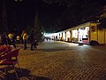
Central square with stands at the Festival of the District 2013

Pieces by Joana Vasconcelos in the sculpture park, the Parque de escultura contemporânea

In the school center of Vila Nova da Barquinha
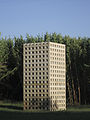
The sculpture Castelo by the sculptor Pedro Cabrita Reis in the sculpture park


Web links
- Map of the Freguesia Vila Nova da Barquinha at the Instituto Geográfico do Exército
- Official website of the city administration
Individual evidence
- ↑ www.ine.pt - indicator resident population by place of residence and sex; Decennial in the database of the Instituto Nacional de Estatística
- ↑ a b Overview of code assignments from Freguesias on epp.eurostat.ec.europa.eu
- ↑ a b www.ine.pt - indicator resident population by place of residence and sex; Decennial in the database of the Instituto Nacional de Estatística
- ↑ History page Vila Nova da Barquinhas ( Memento of the original from September 30, 2014 in the Internet Archive ) Info: The archive link was inserted automatically and has not yet been checked. Please check the original and archive link according to the instructions and then remove this notice. from the district administration website, accessed June 21, 2014
- ^ Publication of the administrative reorganization in the Diário da República gazette of January 28, 2013, accessed on June 19, 2014
- ↑ Entry Vila Nova da Barquinhas in the list of town twinning on the website of the Association of Counties in Portugal, accessed on June 14, 2014

Abrantes | Alcanena | Almeirim | Alpiarça | Benavente | Cartaxo | Chamusca | Constância | Coruche | Entroncamento | Ferreira do Zêzere | Golegã | Mação | Ourém | Rio Maior | Salvaterra de Magos | Santarém | Sardoal | Tomar | Torres Novas | Vila Nova da Barquinha