
Fogo
| Fogo | ||
|---|---|---|
 |
||
| Waters | Atlantic Ocean | |
| Archipelago | Ilhas de Sotavento | |
| Geographical location | 14 ° 57 ′ N , 24 ° 23 ′ W | |
|
||
| length | 26.1 km | |
| width | 26.2 km | |
| surface | 476 km² | |
| Highest elevation |
Pico do Fogo 2829 m |
|
| Residents | 38,600 81 inhabitants / km² |
|
| main place | Sao Filipe | |
 |
||

Fogo (or Ilha do Fogo , German: "Island of Fire") is one of the Cape Verde Islands in the Atlantic . It belongs to the Cape Verde archipelago of Ilhas de Sotavento (German: " Islands under the wind ") and is located east of Brava and west of Santiago .
geography

The island has the shape of a completely regular volcanic cone ( stratovolcano ) with a huge caldera in which a smaller cone has built up and today forms the summit of Pico do Fogo (English: " summit of fire "). The Pico do Fogo is at an altitude of about 2,829 meters above sea level, the highest elevation of the Cape Verde Islands and whose only active volcano and by the Pico del Teide , the Pico Viejo and Pico Basile , the fourth highest in the Atlantic .
Fogo sits together with the island of Brava and the Cadamosto Seamount on a common base of the Cape Verde sill , separated from the next island of Santiago by deep water. The bottom of the Atlantic is here 5300 m below sea level.
Only the heights and slopes on the northeast side are green all year round, while otherwise desert and steppe-like dry regions predominate. As the southernmost and mountainous island, Fogo receives the most precipitation on the Cape Verde Islands, which makes dry farming possible on an irregular basis. However, there are no rivers carrying water all year round. On some farms - e.g. B. in the south of the island in Salto - with the help of artificial irrigation vegetables (especially cabbage and paprika) are grown. Papayas and tamarinds also thrive here. The mountain slopes in the northeast of the island are used to grow coffee. The locals use the lava as a building material.
The district capital is São Filipe with 8300 inhabitants. The second largest town is Mosteiros with around 5000 inhabitants.
geology
Fogo is the only island in Cape Verde with recent volcanism. With around 30 eruptions since its discovery in the 15th century, it is one of the most active volcanic islands on earth. According to Foeken, their geological development can be divided into four stages (from young to old):
- Stage of the Chã das Caldeiras group
- Stage of the Monte Amarelo group
- Stage of the Monte Barro group
- Seamount stage
The seamount stage consists of raised alkali basalts and carbonatites that overlay approximately 1,000 meters thick, pre-volcanic sediments at a depth of 4,000 meters. The sediments in turn lie on the oceanic crust of the Lower Cretaceous , which here extends from 5300 meters to a depth of 13 kilometers. The seamount stage was dated around 4.5 million years BP in the early Pliocene ( Zancleum ). Discordant on the deposits of the seamount stage are the lavas of the Monte Barro group that have emerged on the surface and for which no age information is available yet. The overlying, 2000 to 3000 meters thick Monte Amarelo Group forms the climax of Fogo's volcanic activities with the construction of the Amarelo volcano (shield stage). Mainly undersaturated, highly alkaline, basic to intermediate lavas were funded. The group is assigned a Quaternary age. It ended in the period 123,000 to 62,000 years BP with a gigantic, east-facing, late Pleistocene flank collapse, to which the construction of the summit fell victim. The course of the collapse is marked today by the 1000 meter high Bordeira demolition . In the remaining caldera , from 62,000 years BP, the approximately 2000 meter thick deposits of the Chã das Caldeiras group, mainly rocks of the alkaline differentiation series Basanite / Tephrite, collected . The stratovolcano Pico do Fogo was built on top of this , and its historical eruptions are also made up of basanites, tephrites, foidites and phonotephrites . In 1680 there was such a violent eruption that the mountain was visible for hundreds of kilometers at night and served as a natural lighthouse for shipping for many years. This gave the island the new name Ilha do Fogo. The eruptions at Pico do Fogo were concentrated on the central vent until 1769, but flank eruptions have occurred since 1785. The Chã das Caldeiras group also includes smaller, discontinuous lava flows and cinder cones on the outside of the former Amarelo volcano. The parasitic volcano inside the caldera that formed during an eruption in 1995 was active again on November 23, 2014 and spat ash clouds and fire. The emerging lava, which poured into the caldera with three main streams, destroyed two villages and several other small settlements in the caldera. The volcanic activity ended on February 8, 2015.
According to Madeira, among other things, a classic caldera collapse had occurred before the catastrophic flank tearing off, leaving two interlocking craters behind. Furthermore, in their opinion, the following flank tear represents two separate events.
history
Fogo was discovered in 1460 by the Italian captain Antonio da Noli and was initially called São Filipe . As early as 1500 free, aristocratic Portuguese settled as feudal lords and established a classic slave-holding planter system. They participated in the transcontinental slave trade as suppliers and sellers of supplies for the slave ships. The racist stratification of society was more pronounced than on the other islands, where the coexistence between free and slave women in Creole families had become the origin of Creole culture. It was not until the bourgeois revolution in Portugal in 1910 that the nobility and the large landowners took away their absolute supremacy and allowed bourgeois people who had found their fortune in emigrating to North America as early as 1850 to appear as equal competitors. A small museum in São Filipe makes it easier to understand the connections in a vivid way.
flora


Various endemic plants can be found on Fogo :
- Crabo bravo ( Erysimum caboverdiana )
- Língua de vaca ( Echium vulcanorum )
- Losma ( Artemisia gorgonum ), a bitter-tasting medicinal plant
- Totolho ( Euphorbia tuckeyana ).
administration
The island belongs to the southern group of the Cape Verde Islands, the Ilhas de Sotavento . The capital is São Filipe , the second largest town is Mosteiros .
Administratively, Fogo is divided into three districts ( concelhos ) with a total of four municipalities ( freguesia ).
| Concelho (circle) | Freguesia (Municipality) |
|---|---|
| Sao Filipe | São Lourenço |
| Nossa Senhora da Conceição | |
| Santa Catarina do Fogo | Santa Catarina do Fogo |
| Mosteiros | Nossa Senhora da Ajuda |
Economy and tourism
The only larger port on the island of Fogo, the Porto do Vale de Cavaleiros, is 3 km north of the island's capital, São Filipe. After the Atlantic storms had largely destroyed the quay wall, it was renewed in 1999. Another port is located in São Jorge , but it can only be reached by small boats.
Agriculture, including the cultivation of coffee in the northeast of the island and small-scale viticulture , and artisanal fishing are the only notable branches of production. In 2006, 35 tons of coffee were harvested and in 2007 45 tons. In the drought of 2008, the amount of coffee harvested was 21 t. The extraordinary geological and climatic conditions create a coffee that is valued by coffee connoisseurs. The cultivation takes place on small family plots on a mineral-rich volcanic soil at heights of up to 2000 m in extensive farming, often in a mixed culture together with papaya, beans, manioc, etc. a. Cultivation areas are in the caldera and in the northeast of the island near Mosteiros .
In the 19th century, the cultivation of the physic nut , whose seeds were used to make machine oil, was an important economic factor - the overgrown bushes can still be found in many places on Fogo today. Trade, commerce and private households mainly live on income from emigration. Some of the family members who have emigrated to the USA, Canada, Venezuela or Brazil, even after several generations, regularly send money home , even if the sender and recipient no longer know each other personally. Tourism started slowly and with a qualified base, as the island is mainly suitable for hiking and cultural-historical tourism and not for beach tourism. Swimming in the sea is only possible in a few places on Fogo, e.g. B. on the beach Ponta da Salina near São Jorge and on the beach Praia Casa near Cova Matinho on the east coast.
In addition to the historic city center of the district city of São Filipe, the village of Chã das Caldeiras in the main crater with a wine-growing cooperative and overnight accommodation before the ascent to Pico do Fogo , the island's main attraction, is of great tourist interest . Almost all the buildings in the Bangaeira district are made of black lava stone, and the main street is also paved with lava blocks. The Pico do Fogo can be easily reached from São Filipe via a good road via Salto and Monte Largo . Particularly pretty hiking trails run through the wooded slopes in the northeast of the island near the small town of Mosteiros . In contrast to the well-known Cape Verde islands Boa Vista and Sal, tourism is not very well developed, also because there are no direct flights, but the island can only be reached via Santiago. Big tourism companies haven't found any business here. Therefore, almost without exception, there are small pensions and hotels under owner management on Fogo. Other sources of income besides running accommodation can be found in independently operating tourist guides.
Image gallery

Fogo relief from satellite data

Pico do Fogo - village houses in the Caldeira at an altitude of 1,600 m
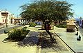
Island capital São Filipe, Praça

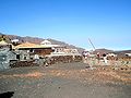
The port of Vale de Cavaleiros (north of São Filipe) in 1994 before its extensive renovation
Viticulture cooperative in Chã das Caldeiras

Main street in Bangaeira village

Physician nut bush on the east coast of Fogo
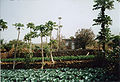
Farm with artificial irrigation in Salto in the south of Fogo

Location Bangaeira, was under the lava in 2014
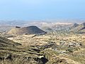
Landscape with a volcanic hill

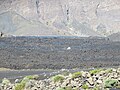
Inside the crater, with the lava that engulfed the road in 2014.
Buildings under the lava of the 2014 eruption
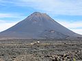
Pico de Fogo 2017

Ponta da Salina before renovation in 2019

Mosteiros
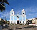
Nossa Senhora da Conceição Church, São Filipe


References
- ↑ Torres, P. et al .: Carta geológica das erupções históricas da Ilha do Fogo: revisão e actualização . Ed .: Réffega, A. et al. Ministério da Ciencia e da Tecnologia, Instituto de Investigação Científica Tropical. Lisbon 1997, p. 119-132 .
- ↑ Foeken, J., Day, S. and Stuart, F .: Cosmogenic 3 He exposure dating of the Quaternary basalts from Fogo, Cape Verdes: implications for rift zone and magmatic reorganization . In: Quaternary Geochronology . tape 4 , 2009, p. 37-49 .
- ↑ Pim, J. et al .: Crustal structure and origin of the Cape Verde rise . In: Earth Planet. Sci. Lett. tape 272 , 2008, p. 422-428 .
- ↑ Kokfelt, T .: A geochemical and isotopic study of the Island of Fogo, the Cape Verde Islands . In: PhD thesis. University of Copenhagen . 1998, p. 164 .
- ↑ Madeira, J .: The role of mass movements on the geomorphologic evolution of island volcanoes: examples from Fogo and Brava in the Cape Verde archipelago . In: Comunicações Geológicas . tape 95 , 2008, p. 93-106 .
- ^ Reitmaier, Pitt: Cabo Verde , p. 385. Bielefeld 2009.
- ^ Lipps, Susanne: Cape Verde Islands , p. 262. Ostfildern 2009.
- ↑ Reitmaier, Pitt: Cabo Verde , p. 108.Bielefeld 2009.
Web links
Ilhas de Barlavento : Boa Vista | Ilhéu Sal Rei | Ilhéu Branco | Ilhéu Raso | Sal | Ilhéu Rabo de Junco | Santa Luzia | Santo Antão | São Nicolau | São Vicente | Ilhéu dos Pássaros
Ilhas de Sotavento : Brava | Fogo | Ilhéus do Rombo : Ilhéu Grande | Ilhéu de Cima | Maio | Ilhéu Laja Branca | Santiago