Ilhéus do Rombo
| Ilhéus do Rombo | ||
|---|---|---|
| Satellite image | ||
| Waters | Atlantic Ocean | |
| archipelago | Cape Verde Islands | |
| Geographical location | 14 ° 58 ′ N , 24 ° 41 ′ W | |
|
|
||
| Number of islands | 5 | |
| Main island | Ilhéu Grande | |
| Total land area | approx. 4.75 km² | |
| Residents | uninhabited | |
| Location of the archipelago | ||

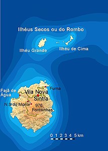
The Ilhéus do Rombo (also Ilhéus Secos ) group of islands is part of the southern group ( Ilhas de Sotavento ) of the Cape Verde Islands . The small archipelago is a few kilometers west of Fogo and only 6 km northeast of Brava , the smallest inhabited island in Cape Verde.
The Ilhéus do Rombo include the two somewhat larger islets Ilhéu Grande (3 km²) and Ilhéu de Cima (1.5 km²) as well as three much smaller islets ( Ilhéu do Rei, Ilhéu Sapado, Ilhéu Luís Carneiro ) with a total area of around 0 , 25 km². In addition, there are numerous individual rock pillars in front of and between the islands, which make it difficult to moor by ship. The larger of them have proper names.
All the islands of the Ilhéus do Rombo are uninhabited and poor in vegetation. The two largest of the Ilhéus in particular have beautiful sandy beaches that are occasionally used by bathing tourists.


