Santa Luzia (Cape Verde)
| Santa Luzia | ||
|---|---|---|
| Satellite image | ||
| Waters | Atlantic Ocean | |
| Archipelago | Ilhas de Barlavento | |
| Geographical location | 16 ° 46 ′ N , 24 ° 45 ′ W | |
|
|
||
| length | 12 km | |
| width | 4.3 km | |
| surface | 34 km² | |
| Highest elevation |
Topona 397 m |
|
| Residents | uninhabited | |
| Topographic map of Santa Luzia | ||
Santa Luzia (German: " Saint Lucia ") is one of the Cape Verde islands in the Atlantic. The island is currently uninhabited.
geography
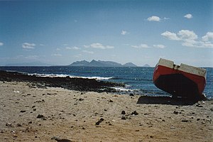
Santa Luzia belongs to the northern island group of Ilhas de Barlavento (German: " Islands above the wind ") of the Cape Verde Islands and is located between the islands of São Vicente and São Nicolau . It is 8 kilometers from northwest São Vicente and 29 kilometers from southeast São Nicolau. At its widest point in the north, the island is 4.3 kilometers long and 12 kilometers long. The area is 34 km². The highest point is the Topona (Monte Grande) with 397 m. The island is very dry and has only one water point. The north-east coast, exposed to the trade winds , is quite rough and rugged, the wind-turned south-west coast forms a long bay (with a sandy beach and dunes), where Atlantic sailors and fishermen prefer to anchor. The island can be reached by fishing boats from Calhau (São Vicente). The crossing takes two hours.
A weather station was built on the island in the 20th century .
Administratively, Santa Luzia belongs to São Vicente.
geology
Santa Luzia is exclusively of volcanic origin. The substructure of the island lies on about 122 million years old oceanic crust of the Lower Cretaceous ( Aptian ). The shield stage of the island is likely to have started about 7 million years ago in the Messinian , like the neighboring island of São Vicente . The lava flows building up the shield generally show a dip to the southwest. The shift package is traversed by several gang flocks, which are mainly oriented NW-SE. The leveling stage of the shield then took place from the Pliocene around 5 million years ago. Santa Luzia has been in its post-erosional phase since the New Pleistocene . Aeolian deposits, which cover the great depression in the southeast part of the island in particular, and alluvial fans date from the Holocene .
history
The island was uninhabited until the 17th century. In the 18th and 19th centuries it was used several times by shepherds from São Nicolau as pasture. Until the 1960s there was even a small community on Santa Luzia. However, this was given up again due to lack of water. Since the beginning of the 21st century, the island has been uninhabited again due to increasing desertification . However, it is occasionally visited by fishermen from São Vicente, who spend the night here in primitive shelters.
Nature reserve
Santa Luzia, together with the islands of Ilhéu Branco and Ilhéu Raso to the southeast, was declared a nature reserve in 2003 for reasons of fauna (reptiles, birds) (the island previously had an endemic species of lizard ).


