Passat (wind system)


A trade wind ( Portuguese passar 'pass', 'run past', 'pull', 'walk' or Italian passata 'crossing') is a moderately strong and very constant wind that can reach up to 30 ° in the tropics or subtropics latitude occurs around the globe.
Distinction
A distinction is made between two Passats with different main wind directions :
- Northeast trade wind in the northern hemisphere
- Southeast trade wind in the southern hemisphere
The direction from which a wind blows gives it its name. The northeast trade wind therefore blows from the northeast, the southeast trade wind from the southeast.
The Innertropical Convergence Zone (ITC or ITCZ) lies between the Passat Zones, a zone that is predominantly windless due to the vertically rising air masses, also called Kalmen , in which the winds usually only blow weakly and from different directions (see also Walker circulation ).
The Passat can have different properties depending on the nature of the earth's surface. When it blows over bodies of water, it absorbs moisture and, as a relatively constant, onshore wind, brings regular rainfall to the coastal areas. However, if it sweeps over land masses, the moisture content of the air masses dried by ascent in the ITC and descent remains low and causes dry (desert) climates in large regions.
Formation of the trade winds (basic principles)
Near the equator, the sun is almost vertical at noon (up to 90 ° angle of incidence, i.e. at the zenith ) and thus warms the air above the ground very strongly, although the days are only 12 to a maximum of 13.5 hours long. The heated air loses density and rises, creating a “ low pressure channel ” below (along the ITC) above the ground .
When ascending, the air cools adiabatically , so that water condenses (cloud formation) and heavy thunderstorms often fall . Via evaporation on the ground and condensation at height, which releases heat, additional thermal energy is carried up from the earth's surface. At the tropopause (around 15 to 18 kilometers above sea level) the air flows north and south away from the equator. The air cools down further, but remains relatively warm compared to the air masses at higher latitudes. The temperature stratification of the very warm air from the ITC above the comparatively less warm air of the higher latitudes creates the stable version of the Passatin , which largely prevents vertical air exchange. When moving towards the pole, the air masses are compressed into a narrower space, because the meridians from the equator to the poles are getting closer and closer to each other. The distance between two meridians at the equator is around 111 km, but only around 96 km at the 30th parallel. The converging air masses have to move towards the ground despite their lower density. A large part of the air masses flowing towards the pole sinks in the area around 30 ° north or 30 ° south. This creates stable high pressure areas in these regions . The air warms up as it descends.
The air flowing out of the high pressure area now follows the air pressure gradient again, so main currents blow towards the equatorial low pressure channel . These winds are relatively stable and are deflected to slightly easterly winds (i.e. coming from the east) due to the earth's rotation (see Coriolis force ), namely to the right in the northern hemisphere and to the left in the southern hemisphere. This creates the northeast and southeast trade winds, which, however, shift in the north-south direction over the course of the year (see the following section ). These winds are so characteristic in terms of their direction, strength and temperature and precipitation conditions that they were named early on and their formation was investigated.
The confluence of the trade winds in the tropical latitudes gives the intertropical convergence zone its name.
The classification of the trade winds in the context of global wind systems is described under Planetary circulation .
Shifts in the course of the year

Due to the inclination of the ecliptic , the zenith of the sun shifts over the course of the year: on the day of the summer solstice (beginning of summer) the sun is over the tropic , on the day of the winter solstice (beginning of winter) it is over the southern. Due to the seasonal change in solar radiation, the intertropical convergence zone shifts and with it the wind system of the Passat circulation between the two tropics. As a result, many tropical regions regularly come under the influence of the northeast and southeast trade winds alternately over the course of the year. The course of the intertropical convergence zone can also be influenced by the distribution of land and water masses and their different warming behavior as well as by the ridges of large mountain ranges . For example, the Innertropical Convergence Zone shifts unusually far beyond the 35 ° latitude through the Himalayas, especially via Northern Pakistan and India .
Since the moisture content of the trade winds depends on whether they move over water or land, the resulting amount of precipitation in the northeast and southeast trade winds can be very different. In such cases, there are seasonal fluctuations in the amount of precipitation, known as the rainy and dry seasons . For example, on the Gulf of Guinea in West Africa, the rainy season is from May to July (south-east trade winds), while the rest of the year is dry (north-east trade winds). The world's coastal deserts (such as the Atacama Desert in northern Chile ) are also caused by dry trade winds.
history
The Passatz circulation, i.e. the earth-encompassing air flow of the trade winds, was first described factually correctly by George Hadley in 1735 , around a hundred years before Gaspard Gustave de Coriolis recognized the Coriolis force more generally as the cause of the deflection of movement in a westerly direction. The air circulation system from which the Passats originate is therefore called the Hadley cell . Because of its persistence, the Passat was and is used by sailing ships to quickly cross the oceans. This was particularly true at the time of the sailing ships, which, due to square sails, could only cross with difficulty against the wind and achieved significantly higher speeds in lateral or stern winds. Even today, sailors like to set their route in the trade winds because of the predictable wind directions. Even if this increases the distance to be sailed, exploiting the trade winds can reduce travel times.
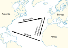
The northeast trade wind was a component of the Atlantic triangular trade in the early modern period. European sailing ships first sailed south on the west coast of Africa, until a swift voyage west was possible in the northeast trade winds. On the American coast they used the north-going ocean current to get from the Gulf of Mexico to the westerly wind zone of the northern hemisphere and also to use the Gulf Stream to return to Europe .
The change in wind direction over the Indian Ocean
If the ITC shifts very far to the northern hemisphere, the southeast trade wind crosses the equator and is then no longer deflected to the west by the Coriolis force, but to the east. As a result, the south-east trade wind turns south-westerly (i.e. it comes from the south-west). This happens regularly over the Indian Ocean because the ITC migrates unusually far north via India and Pakistan at the beginning of summer (to beyond the 30th parallel north).
Tropical waves
The tropical waves ( easterly waves ) are embedded in the trade wind . While the bottom current blows from the north-east or south-east, at altitudes above approx. 2000 m there is mostly a pure east current, the so-called original trade wind. This band of winds parallel to the width sometimes begins to oscillate and a wave-like current forms with a wavelength of around 15 to 30 degrees of longitude. In the area of these waves, high-reaching spring clouds with heavy rain showers arise in a north-south direction. These bad weather areas migrate westwards at a train speed of approx. 22 km / h and can be the nucleus of tropical cyclones .
See also
Web links
Individual evidence
- ↑ Wolfgang Latz (Ed.): Diercke Geographie. Bildungshaus Schulbuchverlage Westermann 2007. Pages 32–37 and 110–121.


