Sao Vicente (Cape Verde)
| Sao Vicente | ||
|---|---|---|
| satellite image | ||
| bodies of water | Atlantic Ocean | |
| archipelago | Ilhas de Barlavento | |
| Geographical location | 16° 51′ N , 24° 58′ W | |
|
|
||
| length | 18 km | |
| broad | 22 km | |
| surface | 227 km² | |
| highest elevation |
Mount Verde 750 m |
|
| resident | 83,000 366 inhabitants/km² |
|
| main place | Mindelo | |
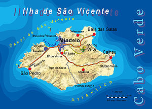
| Map of the island | ||
São Vicente (actually Portuguese Ilha de São Vicente 'Island of Saint Vincent ' ) is one of the smaller Cape Verde Islands in the Atlantic. The 227 km² island belongs to the northern archipelago of Ilhas de Barlavento (port: "Islands above the wind") and lies between the islands of Santo Antão and Santa Luzia , around 640 kilometers west of the African coast. The port city of Mindelo gives the almost exclusively urban island its character. Outside there are two smaller fishing villages and a few weekend settlements.
geography
The low-mountain, dry island is of younger volcanic origin. Above wide valleys filled with boulders, gravel and sand rise three low mountain ranges, some of which are rocky and rugged. The highest elevation at 750 m is the table mountain of Monte Verde (Portuguese: "green mountain"). A huge submarine volcanic crater in the northwest of the island forms one of the most beautiful and safest natural harbors in the Central Atlantic, the Porto Grande.
geology
The geological development of São Vicente can be broken down as follows (from young to old):
- Abrasion and quaternary deposits
- Recent volcanic rocks
- Monte Verde Formation
- Ultra alkaline vents and intrusions
- Praia Grande flank collapse
- Madeiral Monte Cara Formation
- Mindelo Formation
- basal complex
It begins in the Tortonian about 9 million years ago with the submarine seamount stage of the Basal Complex, which overlies 118 to 120 million year old Aptian oceanic crust . The seamount is composed of basaltic alkaline rocks , predominantly picrobasalts , basalts and basanites . The basal complex is traversed by east-west trending (N 080 and N 110) dikes . From the Messinian 6.5 million years ago, a shield volcano grew over the seamount with the Mindelo Formation (picrobasalts and basanites). The Mindelo Formation is also intruded by countless dikes organized in a three-armed (N 030, N 120 and S 240) rift system meeting at the eruption center . The Pahoehoe Rivers are heavily interspersed with sills . With the subsequent Madeiral-Monte Cara Formation , the São Vicente volcano changed its configuration to an ordinary compound stratovolcano, reaching a diameter of 10 to 12 kilometers and a minimum height of 2500 meters. This development was completed 4.5 million years ago.
During the Zancleum 4.5 million years ago, the northeast flank of the volcanic edifice collapsed northeast in a cataclysmic event. The Praia Grande flank collapse left a 10 × 12 kilometer depression that was gradually filled by nephelinitic lava flows and associated carbonatites , foidites , and phonolites of the Monte Verde Formation over the period 4.5 to 3.1 million years ago . Its course is marked by avalanche-like debris breccias in the Ribeira do Calhau valley. It is also assumed that similar flank collapses also occurred on the SW and NW sides of São Vicente (São Pedro and Mindelo flank collapses). In the Upper Pliocene (period 3 to 2 million years before present - Piacenzian and Gelasian ) volcanic activity came to an end. The volcano was now subject to severe erosion and lost up to 90% of its volume. About 300,000 years ago, the volcano reawakened to recent volcanism, which remained relatively insignificant with isolated strombolian eruptions in the northeast and east of the island. For example, the Basanite cinder and cinder cones of Vulcão Viana and Curral de João Paula emerged . Towards the end of the Quaternary , some abrasion platforms and exposed beaches, which can reach elevations of up to 18 meters above sea level , remain . Aeolian deposits and alluvial fans are also occasionally encountered.
story
São Vicente was discovered on January 22, 1462, the day of Saint Vincent of Valencia . Because of its lack of water, the island was only used for grazing cattle by some owners of the neighboring island of Santo Antão.
Up until the 19th century, the natural harbor on the almost uninhabited island served as a hideout for deep-sea pirates. With the emergence of steamships in the 1850s, it became one of the largest coal transhipment points within a decade. The port city of Mindelo, which emerged in the days of the coal trade and flourished again in the 1880s as the largest switchover station for British telegraph companies, still bears the influences of Portuguese and English culture in its historic city center today.
The regional and port city developed into the national economic and cultural center of the small country with an interesting intellectual and artistic life.
The most prominent artist of São Vicente is the singer Cesária Évora , who died in 2011 .
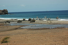
In May and June 2006, the island was the scene of the first NATO maneuvers on African soil. 7,800 soldiers took part in Operation Steadfast Jaguar.
administration
The island belongs to the northern group of Cape Verde Islands, the Ilhas de Barlavento . The undisputed most important place on the island is Mindelo , the second largest city in Cape Verde.
Administratively, São Vicente is divided into a county ( Concelho ) of the same name with only one municipality ( Freguesia ) named Nossa Senhora da Luz . The uninhabited island of Santa Luzia also belongs to the district.
economy and tourism
The urban island lives today from the port, from light industry and its commercial and administrative functions for the archipelago of Barlavento. A music festival is held annually in Baia das Gatas.
The Instituto Nacional de Desenvolvimento das Pescas (INDP) in Mindelo works partly in close cooperation with GEOMAR . The Cape Verde Ocean Observatory (CVOO) , an atmospheric research station with measuring devices from various universities and institutes, is also located on São Vicente .
Culture
authors
- Germano Almeida
- Corsino Fortes
- Manuel Lopes
- Onesimo Silveira
- Ovidio de Sousa Martins
Artists
- Cesaria Evora
- Manuel de Novas
- Tchale Figueira
- Luis Ramos Morais
- Vasco Martins
poets
Language Creole, Portuguese
Other sons and daughters
- Luís de Montalvor (1891–1947), Portuguese writer, co-founder of the influential Orpheu magazine
- Dulce Almada Duarte (1933–2019), Cape Verdean linguist and former PAIGC resistance fighter
- Georgina Mello , Cape Verdean economist and Director General of the Community of Portuguese Speaking Countries (CPLP)
- Emerson dos Santos da Luz (born 1982), footballer
- Edson Rolando Silva Sousa (born 1983), Portuguese footballer
- Rolando Jorge Pires da Fonseca (born 1985), footballer, Portuguese international
See also
literature
- Augusto Guilherme Mesquitela Lima: A Poética de Sérgio Frusoni: Uma Leitura Antropológica (= Diálogo: Série Convergência, ISSN 0871-4444 ). Instituto de Cultura e Língua Portuguesa, Lisbon, 1992, ISBN 978-972-566-177-2 (Poems in São Vicente Creole with Portuguese translation)
- Maria Luiza Braga: Left-dislocation and topicalization in Capeverdean creole . PhD PhD thesis at the University of Pennsylvania, 1982
- Sergio Frusoni : Textos Crioulos Cabo-Verdianos . In: Marius François Valkhoff , Willy Bal (eds.): Miscelânea luso-africana: colectânea de estudos . Junta de Investigações Científicas do Ultramar, Lisbon, 1975, LCCN 80-145933
- Bartolomeo Rossetti (ed.): Vangêle contód d'nôs móda . Translated by Sergio Frusoni. Edição “Terra Nova”, S. Filipe-Fogo (Cape Verde), 1979, LCCN 89-142924 (New Testament in São Vicente Creole)
web links
itemizations
- ↑ Ancochea, E. et al.: Volcanic evolution of São Vicente, Cape Verde Islands: The Praia Grande landslide . In: Journal of Volcanology and Geothermal Research . tape 198 , no. 1–2 , 2010, pp 143-157 .
- ↑ R Muller, M Sdrolias, W Roest: Age, spreading rates and spreading symmetry of the world's ocean crust . In: Geochemistry Geophysics Geosystems . 9 (Q04006), 2008, p. 1525–2027 .
- ↑ R. Ramalho et al.: Tracers of uplift and subsidence in the Cape Verde Archipelago . In: J.Geol. society London . tape 167 , 2010, p. 519-538 .
- ↑ Regional Studies: History. SODADE - Deutsch-Kaperverdische Gesellschaft, accessed January 22, 2017.
- ↑ Gerold Büchner: Landing on Cape Verde. In: BZ Online , June 26, 2006, retrieved on January 22, 2017.
- ^ CVOO website


