Ilhas de Sotavento
| Ilhas de Sotavento | |
|---|---|
| Satellite image | |
| Waters | Atlantic Ocean |
| archipelago | Cape Verde Islands |
| Geographical location | 15 ° 0 ′ N , 24 ° 0 ′ W |
| Number of islands | 9 |
| Main island | Santiago |
| Total land area | 1804 km² |
| Residents | 343,300 |
| Location of the archipelago | |
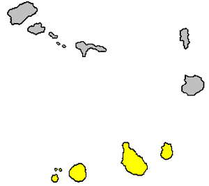
The Ilhas de Sotavento ( German : " Islands under the Wind ") are one of the island groups of the Cape Verde Islands .
The group includes the following islands :
| island | coordinate | Area km² |
Residents |
|---|---|---|---|
| Maio | 15 ° 13 ′ N , 23 ° 10 ′ W. | 269 | 8,400 |
| Santiago | 15 ° 5 ′ N , 23 ° 37 ′ W. | 991 | 290,000 |
| Fogo | 14 ° 57 ' N , 24 ° 23' W. | 476 | 38,600 |
| Brava | 14 ° 51 ′ N , 24 ° 42 ′ W. | 67 | 6,300 |
| Ilhéus do Rombo | 14 ° 58 ′ N , 24 ° 41 ′ W. | 4th | 0 |


