São Jorge (Cape Verde)
| São Jorge | ||
|---|---|---|
|
|
||
| Coordinates | 15 ° 1 ′ N , 24 ° 26 ′ W | |
| Basic data | ||
| Country | Cape Verde | |
|
Archipelago |
Ilhas de Sotavento | |
| District | Sao Filipe | |
| ISO 3166-2 | CV-SF | |
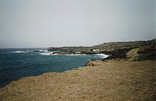
São Jorge is a village with a small port and a beach ( Ponta da Salina ) popular with tourists on the west coast of the island of Fogo, which belongs to Cape Verde . The place is called San Jorji in Creole .
Infrastructure
São Jorge is connected by a well-developed road to the island's capital, São Filipe, which is around 20 km away, and to Mosteiros , the second largest town on the island. The village can be reached several times a day (not on Sundays or public holidays) with the Aluguer buses typical of Cape Verde . However, they do not operate according to a fixed timetable, but depart as soon as enough passengers have arrived.
In São Jorge there is a school and shops for everyday needs, but no accommodation for tourists.
Attractions
Ponta da Salina beach with its coarse-grained black sand near the village is one of the few places on Fogo where you can swim in the sea. It is a popular destination for the residents of São Filipe. It is a natural harbor on a basalt bay that is only used by a few fishermen with small boats. Several rock formations with bizarre shapes rise up from the bay, and a particularly striking, arched rock serves as a natural diving platform. If the sea is not too rough and the wind is not too strong, swimming is possible here.
On the road that leads from the village to the beach, there is an old cemetery surrounded by a wall. Most of the graves are remarkably simple and consist of little more than a wooden cross with no name. The few more elaborate graves form a striking contrast.


