Fogo Island
| Fogo Island | ||
|---|---|---|
| View of Fogo | ||
| Waters | Atlantic Ocean | |
| Geographical location | 49 ° 37 ′ N , 54 ° 12 ′ W | |
|
|
||
| length | 25.3 km | |
| width | 16 km | |
| surface | 254 km² | |
| Highest elevation | Lane's Lookout 128 m |
|
| Residents | 2706 11 inhabitants / km² |
|
| main place | Town of Fogo Island | |
| Outline map of the island | ||
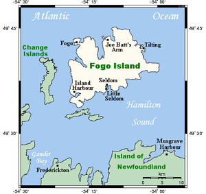
Fogo Island (from Portuguese Ilha do fogo = "island of fire") is a 254 km² island on the Canadian Atlantic coast .
It belongs to the province of Newfoundland and Labrador and lies about 15 km off the north coast of the main island in Notre Dame Bay . The island has an east-west extension of about 25 km and has a hilly, heavily forested terrain with mostly rocky coasts. The highest point is Lane's Lookout on the east side of the harbor, with a height of 128 meters.
In 2006 there were 2706 inhabitants in 11 municipalities on Fogo; The main town is the town of Town of Fogo Island , which was formed in 2011 from four communities on the island and (as of 2011) has 2,400 inhabitants. Fishing, especially cod , has traditionally been the island's main industry.
Until about 1700 Fogo Island was visited by the Beothuk Indian people .
Web links
- Official website of the City of Fogo
Individual evidence
- ↑ Fogo Island in The Canadian Encyclopedia (English)
- ^ Dictionary of Newfoundland English , Toronto 1982-2004, p. 314: Original reference 383 feet


