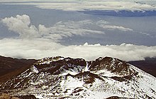
Pico Viejo
| Pico Viejo | ||
|---|---|---|
|
Pico Viejo, crater |
||
| height | 3135 m | |
| location | Tenerife , Canary Islands , Spain | |
| Coordinates | 28 ° 15 '50 " N , 16 ° 39' 53" W | |
|
|
||
| Type | Stratovolcano | |
| Last eruption | 1798 | |
The Pico Viejo , also called Chahorra , with its 3135 meters is the second highest peak on the island of Tenerife and the Canary Islands after the Teide . It is located within the Teide National Park on the south-western flank of the Teide, and forms with this the Teide-Pico-Viejo complex. Its crater has a diameter of 800 m and is up to 250 m deep.
At Pico Viejo, the last eruption so far occurred within the limits of the Caldera Las Cañadas. From June 9th to September 14th, 1798, an eruption of strength 3 of the volcanic explosion index took place on its flank . This created the craters of the Narices del Teide (nostrils of the Teide), and an extensive lava flow was produced.

Pico Viejo crater from the summit of Teide - La Gomera island in the background (February 1983)
Web links
Commons : Pico Viejo - collection of images, videos and audio files
- Pico Viejo in the Global Volcanism Program of the Smithsonian Institution (English)
- Pico Viejo on summitpost.org


