
Teide
| Pico del Teide | ||
|---|---|---|
.jpg) Teide from the northeast (2015) |
||
| height | 3715 msnm | |
| location | Tenerife , Spain | |
| Mountains | Cañadas del Teide | |
| Dominance | 895 km → Ouanoukrim | |
| Notch height | 3715 m | |
| Coordinates | 28 ° 16 '22 " N , 16 ° 38' 32" W | |
|
||
| Type | Stratovolcano | |
| Age of the rock | Young Pleistocene to Holocene | |
| Last eruption | 1909 | |
| First ascent | 1582, Sir Edmund Scory | |
| particularities | highest mountain in the Canaries and Spain | |

The Pico del Teide [ ˈpiko ðel ˈtejðe ], sometimes also Teyde , is at 3715 m the highest point on the Canary Island of Tenerife and the highest mountain on Spanish territory. The third highest island volcano in the world, at 7,500 m above sea level, belongs to the municipality of La Orotava . 18,990 hectares of the mountain region are designated as a national park. In 2007 the area of the El Teide National Park was added to the UNESCO World Heritage List . In 2018 the park was visited by 4.8 million people.
Surname
His name El Teide is the Hispanic form of the Guanche term Echeyde . It refers to the apartment of the evil demon Guayota , who, according to legend, kidnapped the sun god Magec and kept him prisoner in Echeyde.
geology

The Pico del Teide is a stratovolcano . Its slopes are hardly overgrown. It rises from a huge caldera 17 kilometers in diameter called Las Cañadas . According to earlier ideas, it emerged 170,000 years ago from an older volcano whose empty magma chamber collapsed. Today, however, it is assumed that the southern edge of the "caldera" is the "amphitheater" of a debris avalanche that slid north into the sea. Geologists suspect that the submarine plateau in the north of Tenerife is the material of this gigantic slide.
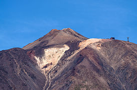
The Teide itself was not created in one step. The Teide-Pico Viejo complex is a stratovolcano formed by the accumulation of material from successive eruptions . The 200 meter high Teide summit El Pitón also emerged from an older crater.
The last eruption on the Teide massif took place on November 18, 1909 at Chinyero , a cinder cone 10 km northwest of the summit. The last eruption within the caldera occurred in 1798 at the Narices del Teide , which is located on the flank of the neighboring volcano Pico Viejo (3134 m) to the west . The only recorded explosive outbreak occurred around 50 BC. BC on the Montaña Blanca on the eastern flank of the Teide, when about 0.25 km³ of DRE pumice stone and ash fell from a 15 km high eruption column .

Phase 1 - 8 million years ago, formation of the Teno, Anaga, Adeje volcanoes

Phase 2 - 5 million years ago, extinction and erosion of the Teno, Anaga, Adeje volcanoes

Phase 3 - 4 million years ago, Cañadas volcanic building emerges

Phase 4 - 3 million years ago, construction of the volcanic building 1 Cañadas

Phase 5 - Modern Times: Building the Teide, Pico Viejo


National Park and Tourism
In 1954 the Teide and the surrounding caldera were designated as a national park. In 2007, the area of the park was awarded the title of UNESCO World Natural Heritage . It was the most visited national park in the EU in 2013 and was the sixth most visited national park in the world. In 2016, more than four million visitors were counted for the first time.
Since the end of the 1990s, compliance with nature conservation has been tightened through the permanent presence of game rangers. Hiking off the beaten track is not tolerated. You can climb the Teide via a well-marked path. At an altitude of 3260 meters there is a shelter belonging to the municipal administration called Refugio de Altavista . The historic building has been renovated and offers overnight accommodation. Alternatively, a cable car , the Teleférico del Teide , leads up to 150 meters below the summit . A network of hiking trails branches out from the mountain station .
Approval from the National Park Administration Office in Santa Cruz de Tenerife is required to climb the summit , which can be requested in person or online. Permission with a time window of two hours is granted free of charge if the conditions on the summit permit ascent and the quota of visitors for the corresponding period has not yet been exhausted.
No permit is required for those who stay in the Refugio de Altavista at 3270 meters above sea level and climb the summit before nine o'clock. In the week after the full moon , the ascent from the Refugio is also possible without a headlamp .
About 13 kilometers northeast of the summit is the Observatorio del Teide of the Instituto de Astrofísica de Canarias (IAC) with its ESA Optical Ground Station ( location ) at an altitude of 2390 meters . It serves on the one hand for satellite observation and on the other hand for testing optical communication technologies for space applications (see Laser Communication Terminal ).
About 3.5 kilometers south of the valley station of the Teide cable car on the TF-21 road is the Roques de García , an ensemble of multi-colored rock needles . The most striking rock is called Roque Cinchado ("Stone Tree"). The rock formations are believed to be the remains of the original volcano.

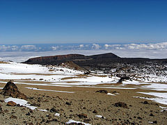
Panoramic view from the Guajara over Las Cañadas, the Teide to Izaña
View from the Montaña Blanca to the Fortaleza

Pico del Teide - north side (March 2014)

Roque Cinchado and Teide

Ucanca plain
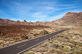
TF-21 with the Roques de García
Mountain station of the Teide cable car with Teide summit


symbol

The Teide as the highest mountain on Tenerife is taken up as a symbol in songs and works of art.
In Tenerife's coat of arms, the Teide appears in a central position during an eruption. Archangel Michael , the patron saint of Tenerife, is located above the Teide .
Others
Mike Oldfield composed a four-minute instrumental piece of music named after the name of Mount Teidi , which appeared on his seventh studio album, Five Miles Out , in 1982 .
For a long time, the Teide was led at an altitude of 3718 meters. This is due to a misunderstanding. Official sites, however, lead the Teide at 3715 meters.
See also
Web links
- Teide in the Global Volcanism Program of the Smithsonian Institution (English)
- GJ Ablay u. a .: Basanite-Phonolite Lineages of the Teide-Pico Viejo Volcanic Complex, Tenerife. In: Journal of Petrology. Vol 39, no. 5 (1998), pp. 905-36. (PDF file, English; 863 kB)
- Instituto de Astrofísica de Canarias - Observatorio del Teide (Tenerife)
- Entry in the UNESCO World Heritage List (English)
Individual evidence
- ↑ a b Spain's highest mountain smaller than expected - Teide does not measure 3718 meters. August 28, 2019, accessed on August 28, 2019 (German).
- ^ Teide National Park. In: whc.unesco.org. Unesco, accessed on July 16, 2017 .
- ^ Aníbal Ramirez: El Teide pulveriza un nuevo rércord de visitantes. In: abc.es. May 30, 2018, Retrieved October 12, 2018 (Spanish).
- ^ DG Masson, AB Watts, MJR Gee, R. Urgeles, NC Mitchell, TP Le Bas, M. Canal: Slope failures on the flanks of the western Canary Islands. In: Earth Science Reviews. 57, Amsterdam 2002, pp. 1-35 ISSN 0012-8252 doi : 10.1016 / S0012-8252 (01) 00069-1
- ↑ GJ Ablay, GGJ Ernst J. Marti, RSJ Sparks : The ~ 2 ka subplinian eruption of Montaña Blanca, Tenerife . In: Bulletin of Volcanology . tape 57 , 1995, pp. 337-355 (English).
- ^ Daniel Millet: El Teide se sitúa entre los diez parques nacionales más visitados del mundo. In: laopinion.es. February 10, 2014, accessed July 28, 2017 (Spanish).
- ↑ M. Plasencia: El Teide bate récord de visitantes y supera los cuatro millones. In: laopinion.es. April 11, 2017. Retrieved July 28, 2017 (Spanish).
- ↑ Permit for climbing the Teides summit. In: reservasparquesnacionales.es. Retrieved August 9, 2019 .
- ^ Altavista refuge. In: webtenerife.de. Retrieved April 29, 2018 .

Historic city centers:
Alcalá de Henares with university (1998) |
Ávila with churches outside the city wall (1985) |
Cáceres (1986) |
Cordoba with Mosque-Cathedral (1984) |
Cuenca (1996) |
Granada with Alhambra and Generalife Palace (1984) |
Salamanca (1988) |
San Cristóbal de La Laguna (1999) |
Santiago de Compostela (1985) |
Segovia with Aqueduct (1985) |
Toledo (1986)
Buildings:
Architecture of the Mudéjares in Aragón (1986) |
Monuments of Oviedo and the Kingdom of Asturias (1985) |
Escorial in Madrid (1984) |
Tower of Hercules (2009) |
Burgos Cathedral (1984) |
Cathedral , Alcázar and Archivo General de Indias in Seville (1987) |
Catalan Romanesque churches in the Vall de Boí (2000) |
Poblet Monastery (1991) |
Monasteries of San Millán de Yuso and San Millán de Suso (1997) |
Royal Monastery of Santa María de Guadalupe (1993) | Monumental Renaissance buildings by Úbeda and Baeza (2003) |
Palau de la Música Catalana and Hospital de la Santa Creu i Sant Pau in Barcelona (1997) |
Puente de Vizcaya (2006) |
Historic sites of mercury mining: Almadén and Idrija (2012) |
Roman city walls of Lugo (2000) |
Valencia Silk Exchange (1996) |
Works by Antoni Gaudí (1984)
Archaeological sites:
Atapuerca (2000) |
Antequera Dolmen (2016) |
Rock art of the Mediterranean on the Iberian Peninsula (1998) |
Altamira Cave and Paleolithic Cave Paintings in Northern Spain (1985) |
Las Médulas (1997) |
Madīnat az-zahrāʾ (2018) |
Mérida (1993) |
Siega Verde * (2010) |
Tarraco (2000)
Cultural and natural landscapes:
Old beech forests and primeval beech forests of the Carpathian Mountains and other regions of Europe (2017, N) |
Aranjuez (2001, K) |
Ibiza (1999, K / N) |
Way of St. James (1993, K) |
Monte Perdido (1997, K / N) |
Doñana National Park (1994, N) |
Garajonay National Park (1986, N) |
Teide National Park (2007, N) |
Palm grove of Elche (2000, K) |
Serra de Tramuntana (2011, K)
* Expansion of the archaeological sites in Vale do Côa , Portugal;