Serra de Tramuntana
| Cultural landscape of the Serra de Tramuntana | |
|---|---|
|
UNESCO world heritage |
|
|
|
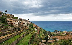
| Terraces of Banyalbufar |
|
| National territory: |
|
| Type: | Culture |
| Criteria : | (ii) (iv) (v) |
| Surface: | 30.745 hectares |
| Reference No .: | 1371 |
| UNESCO region : | Europe and North America |
| History of enrollment | |
| Enrollment: | 2011 (session 35) |
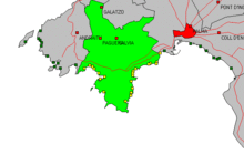
The Serra de Tramuntana ( Castilian : Sierra de Tramontana ) is a mountain range in the northwest of Mallorca . The same name designates one of the six landscape regions ( comarques ) of Mallorca, which is named after the mountain range, but extends somewhat beyond the area of the mountain range. In 2008 the population of the Serra de Tramuntana region was 109,870 registered residents. On June 27, 2011, UNESCO declared the Serra de Tramuntana a World Heritage Site .
geography
The mountains of the Serra de Tramuntana cover an area of 1,067 km² and extend over a length of more than 90 kilometers. They are the habitat of around 20,000 inhabitants, around half of whom live in Sóller . The main mountain range occupies the entire west and north-west part of Mallorca. The Serra de Tramuntana rises to the Puig Major , the highest point in Mallorca, up to 1,445 meters. Below the Puig Major are the two drinking water reservoirs Embassament de Cúber and Embassament des Gorg Blau , which drain their excess water via the Torrent des Gorg Blau into the Torrent de Pareis canyon .
The mountains are easily accessible by roads and many hiking trails. So far it has been largely spared from mass tourism and is ideal for hiking and cycling . The Serra de Tramuntana captivates with its often spectacularly beautiful, wild landscape, which is still covered for long stretches by original vegetation , and with its largely intact, unspoilt nature.
The northern mountains of Mallorca have 54 peaks over a thousand meters, e.g. B.
- Sierra de Son Torrella
- Sierra de Alfabia
- Puig Major
- Puig de Massanella
- Puig Tomir
- Penyal des Migdia
- Puig de l'Ofre
- Puig de Galatzó
- Puig d'en Galileu
Municipalities of the region
| Municipalities: | Residents | Area in km² | Inhabitant / km² |
| Andratx | 11,348 | 81.45 | 139.3 |
| Banyalbufar | 627 | 18.05 | 34.7 |
| Bunyola | 5,910 | 84.63 | 69.8 |
| Calvià | 50,777 | 144.97 | 350.3 |
| Deià | 754 | 15.12 | 49.9 |
| Escorca | 276 | 139.33 | 2.0 |
| Esporles | 4,696 | 35.27 | 133.1 |
| Estellencs | 388 | 13.39 | 29.0 |
| Fornalutx | 732 | 19.49 | 37.6 |
| Pollença | 16,997 | 151.44 | 116.4 |
| Puigpunyent | 1,763 | 42.28 | 41.7 |
| He shall | 13,625 | 42.75 | 318.7 |
| Valldemossa | 1,977 | 42.84 | 46.2 |
Population figures as of January 1, 2008
Flora and fauna
Among the fauna of the area is u. a. the Mallorca midwife toad ( Alytes muletensis ), which was only discovered as a living find in 1979 and is endemic only here. As a curiosity, a two-headed specimen of the harmless hooded snake was found not far from Valldemossa in 2003 . The animal has been referred to in the media as the Hydra of Mallorca (an allusion to the nine-headed, snake-like hydra of Greek mythology). The rare snake can be admired in the reptile zoo in the south of the island (Palma-Manacor motorway).
geology
More than 300 million years ago, towards the end of the Paleozoic Era , the part of the earth's crust known today as Spain was directly involved in the collision of the primary continents Laurentia (present-day North America), Europe and Gondwana (including Africa). As a result of this collision, a huge mountain complex was unfolded across the supercontinent Pangea . Erosion products from this mountain range, deposited in the Permian and the Triassic, are found today in the Serra de Tramuntana in the form of red sandstones and mudstones. The majority of the Serra de Tramuntana and the Serres de Llevant in the southeast and the towering hilly complexes of the central zone of Mallorca consist of Mesozoic limestone, which was mainly deposited in a shallow sea in the Jura 180 million years ago. The surface of the entire island, including the tertiary and quaternary deposits of today's central plain, consists of up to 90 percent limestone.
After the supercontinent Pangea broke up and its parts initially drifted apart, Africa and Europe, including today's Spain, moved towards each other again. The collision of Spain with Africa in the Tertiary about 20 million years ago, the earth's crust, which now forms the island of Mallorca, was compressed by about 50% of its original size. The Jura deposits were literally shredded and pushed over one another several times. In the further course of the Tertiary, large parts of the central area of the island subsided, which in principle resulted in the current threefold structure of the island, Serra de Tramuntana in the northwest, central plain and Serres de Llevant in the southeast. Since the sea level at that time was much higher than it is today, the central plain was completely flooded by the sea. That is why the rocks of the Triassic, Jurassic and Cretaceous were overlaid there by deposits from the later Tertiary.
Heavy rainfall in the Quaternary period transported huge amounts of rubble from the Serra de Tramuntana into the lowlands. Existing cracks and ravines were deepened. The carbon dioxide contained in the rainwater and thus also in the soil water dissolved large amounts of lime, which led to the karstification of the mountain and hill regions of the island. The prominent location, the large fissures, purity and thickness of the limestone increased the karstification ability. The karst phenomena manifest themselves in the form of various caves, particularly in the area of the Serres de Llevant , in the form of fertile collapse depressions filled with recent river sediments (so-called poljen ) in the Serra de Tramuntana and in the form of bizarre, but locally restricted barrow landscapes .
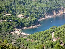
It is a special feature of this coastal mountain range that at altitudes above 600 meters suddenly an, albeit limited, arable zone with isolated settlements appears, while in the lower elevations, terraced fields with orange and almond trees or olive cultivation are only possible in individual valleys. The karst mountains of the north have created a bizarre world of forms, which in their sharp-edged cart fields and the pointed cart ridges, which always have finely structured solution grooves, are reminiscent of small forms from the tropical karst. The individual carts are several meters high and taper upwards in a cone. They stand close together and reveal the individual limestone banks from which they were carved. Such shapes are particularly impressive near the road that crosses the mountains from Inca at the foot of the mountain to the coast at Sa Calobra , as well as near the famous Santuario de Lluc . Similar shapes can be seen on the limestone rocks directly on the rocky coast of the bay of Sa Calobra.
Worth seeing
- Museum Museu de Lluc with finds from the caves in the Escorca area (Prehistòria), ceramics, drawings, paintings, etc.
- Santuari de Lluc
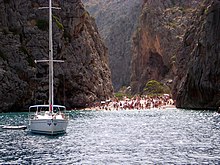
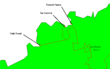
- Torrent de Pareis
- Sa Calobra
- Cala Tuent
hikes
Numerous mountain hikes are possible in this area. The mountain hut (refugi) Tossals Verds is located on the GR 221 long-distance hiking trail , in the heart of the Serra de Tramuntana, at an altitude of 540 meters. It is available to everyone for a small fee and is an ideal starting point to explore the snow houses of the Tramuntana Mountains in the Massanella .
Snow houses
→ Main article: Snow houses in Mallorca
In the days before the electric cooling and freezing systems, snow was collected on the high mountains in the winter months and stored in specially designed houses and condensed into ice; Insulating materials such as straw prevented premature defrosting. In the warm seasons the ice was sold in the lower places. Many of these former snow houses are in various stages of decay in the higher elevations of the Serra de Tramuntana.
Beaches and coves in the Serra de Tramuntana region
Calvià municipality
- Cala Brogit
- Platja d'Illetes
- Cala Comtesa
- Cala Portals Nous
- Oratori de Portals
- Son Caliu
- Es Carregador (Palma Nova)
- Cala Blanca
- Son Maties
- Magaluf
- Cala Vinyes
- Cala Falcó
- Caló de sa Nostra Dama
- Ca l'Aixada (Casino de Mallorca)
- Cala Portals Vells
- Cala en Beltran
- Cala Figuera (Calvià)
- Cala Refaubetx
- El Toro (Racó de sa Fragata)
- Cala de Penyes Roges
- Cala en Guixar
- Caló d'en Pellicer
- Cala de Santa Ponça
- Cala Blanca
- Peguera Romana (Platja des Morts)
- Peguera Torà
- Peguera Palmira
- Cala Fornells
- Cala d'en Monjo
Andratx municipality
- Platja de Camp de Mar (Cala Blanca)
- Cala Llamp
- Cala Marmassem
- it Port d'Andratx
- Cala Moragues
- Cala d'Egos
- Cala d'en Tió
- Cala Conills
- Platja de Sant Elm
- Cala Lladó
- Cala en Basset
- Cala de ses Ortigues
Estellencs municipality
Banyalbufar municipality
Valldemossa municipality
Municipality of Deià
Sóller municipality
Fornalutx municipality
Escorca municipality
Pollença municipality
- Cala Solleric
- Cala Castell
- Cala Estremer
- Cala Sant Vincenç
- Cala Bóquer
- Cala Figuera
- Cala en Gossalba
- Cala Murta
- Cala en Feliu
- Cala Pi de la Posada ( Cala Formentor )
- El Caló
- Platja d'Albercutx
- Platja de Llenaire
- Platja de Can Cullerassa
Quote
The Spanish poet Miquel Costa i Llobera wrote the following about the Serre de Tramuntana:
“Son como grandes olas, la tierra tomada de los tendones inconmensurables acumulan altos en la zona libre de fronteras.”
"They are like great waves that the earth, seized by immeasurable tendons, piles up high into boundless space."
Bibliography
- Pedro Servera: history of Mallorca, origins, historia . Palma de Mallorca 2001, (in numerous publications)
- The Spanish map publisher "Alpina" published hiking maps (1: 25,000) of Mallorca in April 2005 and June 2006. The cards are of high quality. There are three maps: "Tramuntana Sud" (Andratx to Esporles), "Tramuntana Central" (Valldemossa, Deià, Sóller, Bunyola, Alaró, reservoirs) and "Tramuntana Nord" (Fornalutx, reservoirs, Sa Calobra, Lluc, Pollença, Campanet ).
Individual evidence
- ↑ Unesco declares the Tramuntana mountains on Mallorca a world heritage. Mallorca Zeitung (www.mallorcazeitung.es), June 27, 2011, accessed on June 28, 2011 .
- ^ Miquel Costa i Llobera. Retrieved November 1, 2016
Web links
- Serra de Tramuntana (Govern de les Illes Balears)
- Serra de Tramuntana - UNESCO World Heritage status 2010, Cultural Landscape
- Serra de Tramuntana of Mallorca, World Heritage Site
bibliography
- JM Azañon, J. Galindo-Zaldívar, V. Carcía-Dueñas and A. Jabaloy: Alpine Tectonics II: Betic Cordillera and Balearic Islands. Pp. 401-417 in W. Gibbons and T. Moreno (Eds.) The Geology of Spain. The Geological Society of London, 2002, ISBN 1-86239-110-6 (hardcover), ISBN 1-86239-127-0 (paperback).
- V. Rosselló, BW Sellwood and RW Fairbridge: Spain: Balearic Islands. Pp. 683–686 in EM Moores and RW Fairbridge (eds.) Encyclopedia of European and Asian regional geology. Chapman & Hall, London 1997, ISBN 0-412740-400 .


