Puig Tomir
| Puig Tomir | ||
|---|---|---|
|
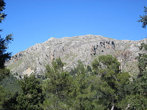
Puig Tomir, seen from the path between Coll Pelat and Coll des Pedregaret. |
||
| height | 1103 msnm | |
| location | Escorca , Mallorca | |
| Mountains | Serra de Tramuntana | |
| Coordinates | 39 ° 50 '42 " N , 2 ° 55' 39" E | |
|
|
||
The Puig Tomir is a 1103 m high mountain in the Serra de Tramuntana mountains on the Spanish Balearic island of Mallorca . It is located near the pilgrimage site of Lluc in the municipality of Escorca .
Routes to the summit
One route begins in the Lluc car park (480 m). From the access road to Lluc, first the long-distance hiking trail GR 221 leads over the Refugi son Amer (540 m) to the Coll Pelat (690 m) and then to the Coll des Pedregaret (650 m).
There the long-distance hiking trail is left and the ascent to Tomir begins. A mountain path leads over scree tongues to a rock plateau, whereby two rocky climbing passages are secured with wire ropes and in some cases with stirrups. The path to the main summit is marked with cairns and runs northeast over the plateau to the summit column. Below the summit there are several snow houses on the eastern slope of the mountain .
Web links
- Puig Tomir at Peakware (English)
- Puig Tomir at summitpost.org
Individual evidence
- ↑ See Rolf Goetz: Mallorca. Bergverlag Rother , 8th edition Munich 2010, p. 126/127

