
Tomar
| Tomar | ||||||
|---|---|---|---|---|---|---|
|
||||||
| Basic data | ||||||
| Region : | Centro | |||||
| Sub-region : | Médio Tejo | |||||
| District : | Santarém | |||||
| Concelho : | Tomar | |||||
| Coordinates : | 39 ° 36 ′ N , 8 ° 24 ′ W | |||||
| Residents: | 40,677 (as of June 30, 2011) | |||||
| Surface: | 351.22 km² (as of January 1, 2010) | |||||
| Population density : | 116 inhabitants per km² | |||||
| Height: | 75 m | |||||
| Postal code : | 2300 | |||||
| Tomar County | ||||||
|
||||||
| Residents: | 40,677 (as of June 30, 2011) | |||||
| Surface: | 351.22 km² (as of January 1, 2010) | |||||
| Population density : | 116 inhabitants per km² | |||||
| Number of municipalities : | 11 | |||||
| administration | ||||||
| Administration address: | Câmara Municipal de Tomar Praça da República 2300-550 Tomar |
|||||
| President of the Câmara Municipal: | Corvêlo de Sousa ( PSD ) | |||||
| Website: | www.cm-tomar.pt | |||||


Tomar [ tuˈmaɾ ] is a Portuguese city ( cidade ) and a district ( concelho ), about 100 km northeast of Lisbon . 40,677 people live here (as of June 30, 2011). Tomar is part of the Rede de Judiarias , an association of places of historically important Jewish communities, which also operate a joint tourist marketing.


history
During the Reconquista , Portugal's first king, D.Afonso Henriques , conquered Tomar from the Moors in 1147 and handed the place over to the Knights Templar in 1159 . Today's place was created when the Templars began building the monastery castle on March 1, 1160. It received its first town charter in 1162 from Gualdim Pais , who at the same time created the independent circle (concelho) of Tomar and is considered the town's founder. With the dissolution of the Templar Order, King D Dinis founded the Portuguese Order of Christ in 1312 as the successor to the Templars. Under the Christ Knight Prince Heinrich, who later became Henry the Navigator , Tomar experienced some boom in the 15th century, to which a growing Jewish community also contributed, who came to Portugal after their expulsion from Castile in 1492.
In 1510, King Manuel I renewed the town charter and Tomar became an important place for artists, with architects and painters such as João de Castilho and Diogo de Arruda working here . In 1844 the previous small town ( Vila ) was elevated to a town on the occasion of the visit of Queen Maria II.
Culture and sights
Burials from the early Neolithic date from the Gruta da Caldeirão (cave) near Tomar . The pottery dates between 5300 and 5100 BC. And belongs to the late cardial .
The city is known by the UNESCO World Heritage Site belonging Convento de Cristo (Convent of Christ), who also dominated the cityscape. It is a combination of castle and monastery of the Knights Templar on a hill to the west of the city, which after the dissolution of the Templar Order in 1312 passed to the Order of Christ and was its center.
Tomar is also known nationwide for the city festival Festa dos Tabuleiros , which takes place every four years in June / July . The city is then filled with many thousands of visitors, who especially want to see the processions, in which girls and women carry decorated trays ( tabuleiros ) with loaves of bread on their heads equal to their height through the decorated streets. The festival dedicated to the Holy Spirit, which has been taking place for centuries, dates back to a procession in which bread was distributed to those in need.
The city houses u. a. a curious match museum , with 80,000 matches and boxes from 115 countries. Other museums include the municipal Museu Municipal João de Castilho , which focuses on exhibitions of old and new art, the Museu Hebraico Abraão Zacuto , which is housed in the medieval synagogue and is dedicated to the Jewish history of Tomar and Portugal, and the Arquivo Fotográfico Photo Museum Silva Magalhães .
On the inner-city river island Parque do Mouchão there is a green area with old trees and an old water wheel, which was built in the Moorish style with clay vessels for scooping the water. A small hotel is set up there.
On the northern edge of the old town stands the octagonal chapel of São Gregorio, built in the 16th century, with a tent roof and a Manueline portal.
Once a month, usually on the fourth and occasionally the third Saturday of the month, there is an organic food market in the central pedestrian zone of Rua Serpa Pinto .
Tomar has a particularly large number of examples of Portuguese paving art, the Calçada Portuguesa , large areas such as the square in front of the town hall and the São João Baptista church , as well as small-scale and artistic examples on sidewalks and small squares.

Parade of the Festa dos Tabuleiros (2003)

South view of the crusader castle

Alley of the Synagogue of Tomar

S. João Baptista Church

In the pedestrian street Rua Serpa Pinto (2007)

In the crusader castle of Tomar (2002)

Manueline window on the crusader church
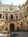
Crusader Convention - Claustro dos Felipes (2005)

Aqueduct - view from the crusader castle Tomar (2005)
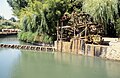
Water wheel in Tomar


administration
circle
Tomar is also the administrative seat of a district of the same name. The neighboring districts are (starting clockwise in the north): Ferreira do Zêzere , Abrantes , Vila Nova da Barquinha , Torres Novas and Ourém .

With the regional reform in September 2013 , several municipalities were merged into new municipalities, so that the number of municipalities decreased from 16 to eleven.
The following municipalities ( Freguesias ) are in Tomar County:

| local community | Population (2011) |
Area km² |
Density of population / km² |
LAU code |
|---|---|---|---|---|
| Além da Ribeira e Pedreira | 1.313 | 24.50 | 54 | 141817 |
| Asseiceira | 2,945 | 29.07 | 101 | 141802 |
| Carregueiros | 1,179 | 12.35 | 95 | 141804 |
| Casais e Alviobeira | 2,965 | 35.96 | 82 | 141818 |
| Madalena e Beselga | 3,990 | 44.44 | 90 | 141819 |
| Olalhas | 1,415 | 34.72 | 41 | 141808 |
| Paialvo | 2,599 | 22.31 | 117 | 141809 |
| Sabacheira | 955 | 34.26 | 28 | 141814 |
| Sao Pedro de Tomar | 3,027 | 36.66 | 83 | 141813 |
| Serra e Junceira | 2,080 | 46.57 | 45 | 141820 |
| Tomar e Santa Maria dos Olivais | 18,209 | 30.38 | 599 | 141821 |
| Tomar County | 40,677 | 351.22 | 116 | 1418 |
Population development
| Population in Tomar County (1801-2004) | ||||||||
|---|---|---|---|---|---|---|---|---|
| 1801 | 1849 | 1900 | 1930 | 1960 | 1981 | 1991 | 2001 | 2004 |
| 16,536 | 16,786 | 31,360 | 39.179 | 44.161 | 45,672 | 43,139 | 43.007 | 42,983 |
Town twinning
-
 Vincennes (France)
traffic

railroad
The city is connected to the national rail network via the Ramal de Tomar line .
bus
The city is integrated in the national bus network of Rede Expressos . In addition, the place is served by some regional bus routes of the Lisbon metropolitan area network.
Streets
Tomar is located on the N113 national road and is about 20 km from the junction Atalaia the A23 motorway away.
Urban transport
The urban transport company TUTomar - Transportes Urbanos de Tomar travel to the 24 stops in the historic center and the school, health and shopping centers in the north of the city with red minibuses every 20 minutes, at peak times every 10 minutes (weekdays from 7:00 a.m. to 8:00 p.m., Saturdays from 8:00 a.m. to 2:00 p.m., Sundays from 2:00 p.m. to 8:00 p.m.). A single trip costs 0.70 euros, a 10-trip card 5.10 euros, and a day ticket 2 euros. In addition, 3-day tickets, 5-day tickets and other subscriptions are possible (as of January 2013)

sons and daughters of the town
- João Anes († 1402), Archbishop of Lisbon
- Manuel Joaquim Nogueira (1787–1862), military man and politician
- José Ribeiro Faria e Silva (1855–1932), doctor
- Tamagnini de Abreu (1856–1924), military, commander of the Portuguese Expeditionary Corps in World War I.
- Fernando Lopes-Graça (1906–1994), composer and conductor
- Nuno Viriato Tavares de Melo Egídio (1922–2011), military, 1979–1981 Governor of Macau
- Isabel Ruth (born 1940), actress
- Paulo Frischknecht (* 1961), Olympic swimmer
- Margarida Cardoso (* 1963), director
- Ana Laíns (* 1979), fado singer
- Melânia Gomes (* 1984), actress
- Patricia Sampaio (* 1999), judoka
literature
- Thomas G. Schattner (Ed.): Archaeological guide through Portugal (= cultural history of the ancient world . Vol. 74). Philipp von Zabern, Mainz 1998, ISBN 3-8053-2313-1 p. 116
Web links
- Official website
- Templars in Tomar. In: philoSIENCE. 2006, accessed July 31, 2001 .
proof
- ↑ a b www.ine.pt - indicator resident population by place of residence and sex; Decennial in the database of the Instituto Nacional de Estatística
- ↑ a b Overview of code assignments from Freguesias on epp.eurostat.ec.europa.eu
- ↑ www.verportugal.net , accessed January 27, 2013
- ↑ www.tabuleiros.org , accessed January 27, 2013
- ↑ www.portugal-libelle.com , accessed on January 27, 2013
- ↑ Article of January 3, 2007 in the weekly newspaper Die Zeit , accessed on January 27, 2013
- ↑ www.cm-tomar.pt ( Memento of the original from January 26, 2012 in the Internet Archive ) Info: The archive link was inserted automatically and has not yet been checked. Please check the original and archive link according to the instructions and then remove this notice. , accessed January 27, 2013
- ^ Lydia Hohenberger, Jürgen Strohmaier: Portugal. 2nd edition, DuMont Reiseverlag, Ostfildern 2009, page 189f
- ↑ Hans Strelocke: Portugal , S. 267. Cologne 1991
- ↑ www.cm-tomar.pt ( page no longer available , search in web archives ) Info: The link was automatically marked as defective. Please check the link according to the instructions and then remove this notice. , accessed January 27, 2013
- ^ Publication of the administrative reorganization in the Diário da República gazette of January 28, 2013, accessed on March 16, 2014
- ↑ www.cm-tomar.pt ( Memento of the original from May 26, 2011 in the Internet Archive ) Info: The archive link was inserted automatically and has not yet been checked. Please check the original and archive link according to the instructions and then remove this notice. , accessed January 27, 2013

Abrantes | Alcanena | Almeirim | Alpiarça | Benavente | Cartaxo | Chamusca | Constância | Coruche | Entroncamento | Ferreira do Zêzere | Golegã | Mação | Ourém | Rio Maior | Salvaterra de Magos | Santarém | Sardoal | Tomar | Torres Novas | Vila Nova da Barquinha
| ← Previous location: Fátima |
|
Next town: Leiria → |