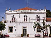
Coruche
| Coruche | ||||||
|---|---|---|---|---|---|---|
|
||||||
| Basic data | ||||||
| Region : | Alentejo | |||||
| Sub-region : | Lezíria do Tejo | |||||
| District : | Santarém | |||||
| Concelho : | Coruche | |||||
| Freguesia : | União das Freguesias de Coruche, Fajarda e Erra | |||||
| Coordinates : | 38 ° 57 ′ N , 8 ° 32 ′ W | |||||
| Coruche County | ||||||
|
||||||
| Residents: | 19,944 (as of June 30, 2011) | |||||
| Surface: | 1 115.72 km² (as of January 1, 2010) | |||||
| Population density : | 18 inhabitants per km² | |||||
| Number of municipalities : | 6th | |||||
| administration | ||||||
| Administration address: | Câmara Municipal de Coruche Praça da Liberdade 2100-121 Coruche |
|||||
| President of the Câmara Municipal: | Francisco Silvestre de Oliveira ( PS ) | |||||
| Website: | www.cm-coruche.pt | |||||
Coruche is a small town ( vila ) in Portugal . It is particularly known for its cork production and its wine.
On September 29, 2013, the municipalities of Coruche, Fajarda and Erra were merged to form the new municipality of União das Freguesias de Coruche, Fajarda e Erra . Coruche is the seat of this newly formed community.
history
Finds show a settlement since the Paleolithic , in particular various megalithic systems in the south of the district. The present place was conquered by the Moors during the Reconquista of Portugal's first King D. Afonso Henriques in 1166 . He gave Coruche first town rights on May 26, 1182. At the same time he raised the place to a small town ( Vila ) and made it the seat of its own circle, which it has remained to this day.
administration
The circle
Coruche is the administrative seat of a district of the same name ( concelho ) in the Santarém district . On June 30, 2011, the district had 8,890 inhabitants on an area of 1,115.7 km².
The neighboring regions are (starting clockwise in the north): Almeirim , Chamusca , Ponte de Sor , Mora , Arraiolos , Montemor-o-Novo , Montijo , Benavente and Salvaterra de Magos .
With the territorial reform in September 2013, the municipalities ( Freguesias ) Coruche, Fajarda and Erra were combined to form the new municipality União das Freguesias de Coruche, Fajarda e Erra . Since then, the district has consisted of the following six municipalities:
| local community | Population (2011) |
Area km² |
Density of population / km² |
LAU code |
|---|---|---|---|---|
| Biscainho | 1,074 | 81.40 | 13 | 140907 |
| Branca | 1,474 | 117.32 | 13 | 140905 |
| Coruche, Fajarda e Erra | 11,756 | 356.48 | 33 | 140909 |
| Couço | 2,765 | 346.61 | 8th | 140902 |
| Santana do Mato | 1,148 | 103.08 | 11 | 140908 |
| São José da Lamarosa | 1,727 | 110.89 | 16 | 140903 |
| Coruche County | 19,944 | 1,115.72 | 18th | 1409 |
Population development
| Number of inhabitants in the Coruche district (1801–2011) | |||||||||
|---|---|---|---|---|---|---|---|---|---|
| 1801 | 1849 | 1900 | 1930 | 1960 | 1981 | 1991 | 2001 | 2011 | |
| 3920 | 4943 | 9634 | 18,317 | 27,437 | 25,278 | 23,634 | 21,332 | 19,931 | |
Municipal holiday
- 17th August
sons and daughters of the town
- Francisco de Brito Freire (1625–1692), noble colonial administrator, governor of Pernambuco
- António Pereira Mouzinho de Albuquerque Cota Falcão (1829–1858), military engineer and colonial administrator
- Américo Durão (1894–1969), poet and playwright
- José Peseiro (* 1960), football coach
- Tucha (* 1975 as Helena Brazão), singer
Web links
- Map of the Freguesia Coruche at the Instituto Geográfico do Exército
- Official website of the city administration
Individual evidence
- ↑ www.ine.pt - indicator resident population by place of residence and sex; Decennial in the database of the Instituto Nacional de Estatística
- ↑ Overview of code assignments from Freguesias on epp.eurostat.ec.europa.eu
- ^ Publication of the administrative reorganization in the Diário da República gazette of January 28, 2013, accessed on October 1, 2014
- ↑ Portrait of the district on the city's visitor website (port.), Accessed on June 14, 2014
- ↑ www.ine.pt - indicator resident population by place of residence and sex; Decennial in the database of the Instituto Nacional de Estatística
- ^ Publication of the administrative reorganization in the Diário da República gazette of January 28, 2013, accessed on March 16, 2014


