Unhais-o-Velho
| Unhais-o-Velho | ||||||
|---|---|---|---|---|---|---|
|
||||||
| Basic data | ||||||
| Region : | Centro | |||||
| Sub-region : | Region of Coimbra | |||||
| District : | Coimbra | |||||
| Concelho : | Pampilhosa da Serra | |||||
| Coordinates : | 40 ° 8 ′ N , 7 ° 49 ′ W | |||||
| Residents: | 458 (as of June 30, 2011) | |||||
| Surface: | 39.57 km² (as of January 1, 2010) | |||||
| Population density : | 12 inhabitants per km² | |||||
| Postal code : | 3320-368 | |||||
| politics | ||||||
| Mayor : | José Lourenço Pereira Batista | |||||
| Address of the municipal administration: | Junta de Freguesia de Unhais-o-Velho Largo José Augusto Veiga Nunes de Almeida 3320-368 Unhais-o-Velho |
|||||
| Website: | www.freguesias.pt/freguesia.php?cod=061209 | |||||
Unhais-o-Velho is a municipality ( freguesia ) in the Portuguese district ( concelho ) of Pampilhosa da Serra . It has 458 inhabitants (as of June 30, 2011).
history
The place existed as a small village before the establishment of the independent Kingdom of Portugal in 1139, and has since been part of the Pampilhosa da Serra district. After the victory of the Liberals in the Miguelistenkrieg and the subsequent administrative reform in 1836, Unhais was assigned to the district of Fajão until it was dissolved again in 1855. Since then the place belongs to Pampilhosa da Serra again.
The origin of the name is unclear. It is presumably derived from a plant that grew rampant here in earlier times, and was called Unhagata (German: clawed cat ) because of its claw-like thorns . According to other assumptions, rock formations near the place gave its name, which resemble fingernails (Portuguese: Unhas). There are also theses that u. a. a derivation from the Huns (port .: Hunos) consider possible. The river Rio Unhais , which runs here, got its name from the place.
Culture and sights

The parish church ( Igreja Paroquial de Unhais-o-Velho , also Igreja de São Mateus ) was built in 1824 and is now a listed building.
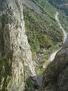
In the almost untouched area, watercourses, forests and rugged rocky outcrops allow a number of natural sports. In particular, there are water sports opportunities at the nearby Santa Luzia reservoir.
administration
The municipality consists of the following localities:
- Aradas
- Malhada do Rei
- Meas
- Portela de Unhais
- Póvoa da Raposeira
- Celadinhas
- Arranhadouro
- Unhais-o-Velho
Web links
Individual evidence
- ↑ a b www.ine.pt - indicator resident population by place of residence and sex; Decennial in the database of the Instituto Nacional de Estatística
- ↑ Overview of code assignments from Freguesias on epp.eurostat.ec.europa.eu
- ↑ www.cm-pampilhosadaserra.pt ( Memento of the original from January 22, 2012 in the Internet Archive ) Info: The archive link was automatically inserted and not yet checked. Please check the original and archive link according to the instructions and then remove this notice. , accessed November 24, 2012
- ^ João Fonseca: Dicionário do Nome das Terras. 2nd edition, Casa das Letras, Cruz Quebrada 2007, page 259 ( ISBN 978-972-46-1730-5 )
- ↑ www.monumentos.pt , accessed on November 24, 2012


