Peniche
| Peniche | ||||||
|---|---|---|---|---|---|---|
|
||||||
| Basic data | ||||||
| Region : | Centro | |||||
| Sub-region : | Oeste | |||||
| District : | Leiria | |||||
| Concelho : | Peniche | |||||
| Coordinates : | 39 ° 21 ′ N , 9 ° 23 ′ W | |||||
| Residents: | 27,753 (as of June 30, 2011) | |||||
| Surface: | 77.54 km² (as of January 1, 2010) | |||||
| Population density : | 358 inhabitants per km² | |||||
| Postal code : | 2520 | |||||
| Peniche County | ||||||
|
||||||
| Residents: | 27,753 (as of June 30, 2011) | |||||
| Surface: | 77.54 km² (as of January 1, 2010) | |||||
| Population density : | 358 inhabitants per km² | |||||
| Number of municipalities : | 4th | |||||
| administration | ||||||
| Administration address: | Câmara Municipal de Peniche Rua António Conceição Bento Mercado Municipal 2520 - 239 Peniche |
|||||
| President of the Câmara Municipal: | António José Correia ( CDU ) | |||||
| Website: | www.cm-peniche.pt | |||||
Peniche (Portuguese pronunciation: [pɨniʃ]) is a located on the Atlantic Portuguese city in the subregion Oeste the Centro region and the historical province of Extremadura , by both the offshore island group of Berlengas and the for surfing suitable waves of the Atlantic has tourist importance. It is Portugal's second largest transshipment point for sardines .
history
Originally, Peniche was an island near the coast. Finds show a prehistoric settlement since the Neanderthals , especially in the Gruta da Furninha . The first humans lived here in caves and especially from fishing. Seafarers from ancient Greece and Phoenicians later settled here. The current place name probably developed from the ancient Greek place name Phenix , a place in Crete that was strongly reminiscent of local events. In particular, the Berlengas archipelago, seen from the coast of Peniche, strongly resembles the characteristic coastline of Gavdos at a comparable point on Crete.
The Romans intensified fishing and produced amphorae here to preserve the fish. A large number of Roman shipwrecks were also found on the rocks of the Berlengas, which testify to brisk trading activity. In the Middle Ages was Atouguia da Baleia ( baleia to German Wal ) in particular by the lucrative whaling was one of the most important place to the Administrative District Peniche. From the 15th century, a natural land connection developed between Peniche and the mainland. Favored by such easier transport routes, the place began to grow at the upper (Peniche-de-Cima) and lower core (Peniche-de-Baixo). In 1609 Peniche was raised to a vila (small town) and the center of its own district.
In addition to fishing, shipbuilding as well as viticulture and grain growing contributed to Peniche's growth. Luís de Ataíde , Count of Atougia and governor of Portuguese India from 1568 to 1581 , had Peniche extensively fortified. The construction of more fortified fortifications to protect against pirate attacks was deemed necessary after British forces landed here in 1589. They tried in vain to come to the aid of the heir to the throne António von Crato in his unsuccessful efforts to achieve the independence of Portugal from the personal union with Spain that had existed since 1580. The British troops were of low combat strength and were easily destroyed by the Spanish troops.
In the course of the administrative reforms after the Liberal Revolution in 1822 and the subsequent Miguelistenkrieg , the Atouguia da Baleia district was dissolved in 1836 and Peniche was incorporated.
On October 27, 1892, the British passenger steamer Roumania drove against the rocky coast in stormy seas, sank and killed 113 people.
As a result of the ongoing technological advances in fishing , preservation and processing of the fish, the related businesses and businesses in Peniche grew. On February 1, 1988, Peniche was elevated to a cidade (city).
Attractions
Buildings
- The fortress of the city of Peniche was built between 1557 and 1570, further fortifications were made until 1645 according to plans by Louis XIII. serving French military engineer Nicolau de Langres. During Salazar - dictatorship were in the fortress of political prisoners detained. Since the later general secretary of the Portuguese Communist Party Álvaro Cunhal and other comrades managed to escape during the famous "Escape from Peniche" on January 3, 1960, it gained a certain degree of notoriety. Today the Museu Regional is located in a part of the building, in which the function of the fortress as a prison during the dictatorship is processed.
- The baroque and mother church Igreja de Nossa Senhora da Ajuda is the oldest in the city from the beginning of the 17th century. The sides of the nave were provided with panels made of azulejos of high artistic quality.
- The lace making is one of the most famous handicraft traditions in Peniche and is cultivated in a school next to the tourist office.
nature
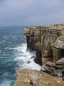
Peniche is located on a peninsula, characterized by a high cliff that slopes gently towards the sea only in the port area and at the northern end. At the westernmost point is the Cabo Carvoeiro with a lighthouse, from where the island group of the Berlengas in the Atlantic is very clearly visible. A path and steps lead from the coastal road to the Gruta da Furninha cave .
South of the peninsula extends the long sandy beach Praia do Medão , whose sub-area Praia dos Supertubos , located right next to the city, is one of the most famous surfing spots in Portugal. Because of its tubular, long-lasting waves and its sandy subsoil, it is rated as perhaps the best in Europe, especially since the walls of the harbor protect against disturbing north winds. But also in the north, where a fine sandy bay stretches over 5 km to Baleal , the sport of surfing is pursued.
administration
The circle
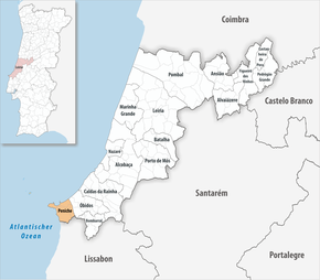
Peniche is the administrative seat of a district of the same name ( concelho ) in the Leiria district . On June 30, 2011 the district had 27,753 inhabitants on an area of 77.5 km².
The neighboring districts are (starting clockwise in the north): Óbidos and Lourinhã . To the west, Peniche borders the Atlantic Ocean .
With the territorial reform in September 2013 , the municipalities ( freguesias ) Ajuda (Peniche) , Conceição (Peniche) and São Pedro (Peniche) were combined to form the new municipality of Peniche , which forms the city of Peniche . The district is therefore divided into the following four municipalities:
| local community | Population (2011) |
Area km² |
Density of population / km² |
LAU code |
|---|---|---|---|---|
| Atouguia da Baleia | 8,954 | 47.02 | 190 | 101402 |
| Ferrel | 2,649 | 13.79 | 192 | 101406 |
| Peniche | 14,749 | 7.81 | 1,889 | 101407 |
| Serra d'El-Rei | 1,401 | 8.92 | 157 | 101405 |
| Peniche County | 27,753 | 77.54 | 358 | 1014 |
Population development
| Peniche County Population (1801–2011) | ||||||||
|---|---|---|---|---|---|---|---|---|
| 1801 | 1849 | 1900 | 1930 | 1960 | 1981 | 1991 | 2001 | 2011 |
| 2460 | 5953 | 8199 | 16,019 | 22,200 | 25,627 | 25,880 | 27,315 | 27,630 |
Municipal holiday
- Nossa Senhora da Boa Viágem (Our Lady for a Safe Journey), Marian holiday on the Monday after the first Sunday in August.
sons and daughters of the town
- Jacob Rodrigues Pereira (1715–1780), educator and developer of a teaching method for the deaf and dumb in France
- Antônio Ferreira Viçoso (1787–1875), spiritual author, bishop in the Archdiocese of Mariana
- Félix António de Brito Capelo (1828–1879), biologist and oceanographer, brother of Hernandogildo Capelo
- Paulino Montez (1897–1988), architect
- Ricardo Costa (* 1940), film director
- José Rachão (* 1952), football coach
- Beto , actually Albertino João Santos Pereira (1967–2010), entertainment singer
- Fernando Silva (* 1972), badminton player
- Telma Santos (* 1983), badminton player
- Hélder Cabral (* 1984), football player
- Tiago Cação (* 1998), tennis player
Web links
- Official website of the city administration (Portuguese and English)
Individual evidence
- ↑ a b c www.ine.pt - indicator resident population by place of residence and sex; Decennial in the database of the Instituto Nacional de Estatística
- ↑ a b Overview of code assignments from Freguesias on epp.eurostat.ec.europa.eu
- ^ Message on taking office , accessed on November 2, 2013
- ^ João Fonseca: Dicionário do Nome das Terras. 2nd edition, Casa das Letras, Cruz Quebrada 2007, p. 197f ( ISBN 978-972-46-1730-5 )
- ↑ Manuel Fernández Álvarez : Felipe II y su tiempo . Espasa, Madrid 1998, ISBN 84-239-9736-7 , p. 575.
- ^ Newspaper article dated November 1, 1892 in the New York Times , accessed November 2, 2013
- ↑ www.verportugal.net , accessed on November 2, 2013
- ↑ Portrait of the surf spot at www.wannasurf.com, accessed on November 2, 2013
- ^ Publication of the administrative reorganization in the Diário da República gazette of January 28, 2013, accessed on March 16, 2014


