Arrabal (Leiria)
| Arrabal | ||||||
|---|---|---|---|---|---|---|
|
||||||
| Basic data | ||||||
| Region : | Centro | |||||
| Sub-region : | Region of Leiria | |||||
| District : | Leiria | |||||
| Concelho : | Leiria | |||||
| Coordinates : | 39 ° 42 ′ N , 8 ° 44 ′ W | |||||
| Residents: | 2684 (as of June 30, 2011) | |||||
| Surface: | 20.09 km² (as of January 1, 2010) | |||||
| Population density : | 134 inhabitants per km² | |||||
| Postal code : | 2420-009 | |||||
| politics | ||||||
| Mayor : | Arlindo Brites Pereira | |||||
| Address of the municipal administration: | Junta de Freguesia de Arrabal Rua José Bernardino Crespo, n.º 23 2420-009 Arrabal |
|||||
| Website: | arrabal.pt | |||||
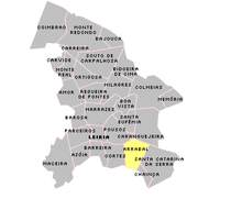
Arrabal is a municipality ( freguesia ) in the Portuguese district of Leiria . It has 2684 inhabitants (as of June 30, 2011).
history
The parish was created in 1592. During the Napoleonic invasions in 1810, Arrabal suffered significant destruction and 317 deaths.
Population development
| 1732 | 1811 | 1890 | 1960 | 1981 | 1991 | 2001 | 2011 |
| 1.006 | 537 | 1,526 | 2.224 | 2,471 | 2,425 | 2,719 | 2,684 |
Culture and sights
The chapel of Ermida de São João Baptista and the u. a. The parish church Igreja Paroquial de Arrabal (also Igreja de Santa Margarida ) showing azulejos from the 17th century is a listed building.
Sons and daughters
- João Lopes Soares (1878–1970), politician and educator, father of Mário Soares
Web links
Individual evidence
- ↑ a b www.ine.pt - indicator resident population by place of residence and sex; Decennial in the database of the Instituto Nacional de Estatística
- ↑ Overview of code assignments from Freguesias on epp.eurostat.ec.europa.eu
- ↑ www.arrabal.pt , accessed December 26, 2012
- ↑ Community website , accessed December 26, 2012


